1770 Lotter Map of Asia
Asia-lotter-1770$850.00

Title
Asia Concinnata Secundum Observationes Academiae Regalis Scientiarum et nonnullas alias, et iuxta annotationes recentissimas.
1770 (undated) 19.5 x 23.5 in (49.53 x 59.69 cm) 1 : 22000000
1770 (undated) 19.5 x 23.5 in (49.53 x 59.69 cm) 1 : 22000000
Description
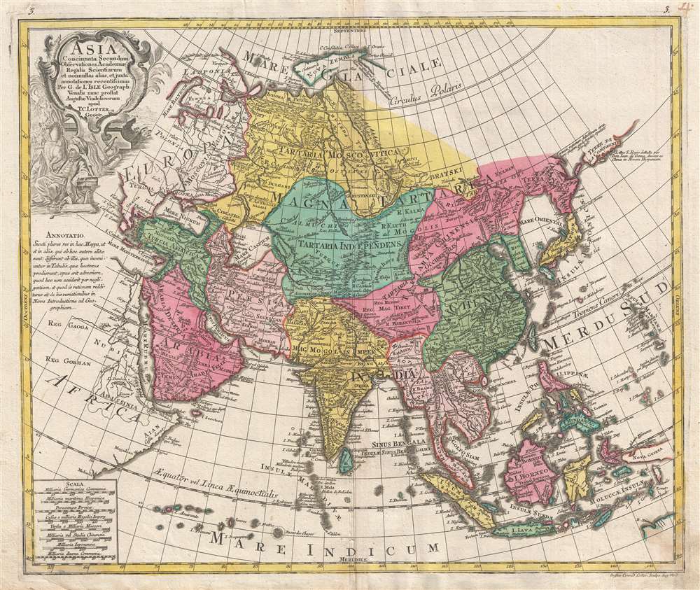
A rare and attractive old color 1770 map of Asia by Tobias Conrad Lotter. Centered on Independent Tartary, this map covers the entire continent from Africa and the Mediterranean east to the Bering Sea and south as far as Java and New Guinea. The map renders the entire region in detail offering both topographical and political information with forests and mountains beautifully rendered in profile.
Searching for da Gama's islands, Vries and Coen skirted the eastern coast of Japan and Hokkaido (then known as Yedo or Yeco) sighting the Japanese Kuril Islands of Kunashir and Iturup. They sailed fully around Kunashir, but only sighted the western shore of the larger Iturup before claiming both islands for the Dutch East India Company (VOC) and naming them Compagnies Landt. Cartographers began combining Gama with Compagnies Landt as a vast singular body of land stretching all the way to America. While based upon actual sightings of the Aleutian and Kuril Islands, limited exploration led explorers to believe they were seeing not a chain of small islands, but rather a part of an expansive mainland. These conclusions would be mirrored later in the 18th century by sophisticated cartographers like Gerhard Friedrich Müller, who rendered the area as a great peninsula, until the dogged and meticulous mapping of Captain James Cook finally shed scientific light on the region.
Cartographic Sources
While published by Lotter, the cartography is that of Guillaume De L'Isle, as noted in the title cartouche. The presentation is most interesting in its rendering of the largely unexplored extreme northeast of Asia. Knowledge of this area was, at the time, speculative at best. Hokkaido, or as it is mapped here, Eso or Yesso, is joined to Sakhalin and is connected to the mainland of Asia, reflecting a common misunderstanding about this region that persisted until the late 18th century.Gamaland and Compagnie Landt
An unusual large landmass outlined in orange that appears extending eastward towards America is labeled after João da Gama. This is a conflation of two separate but related legends/histories. The first refers to the discoveries of Portuguese explorer João da Gama (c. 1540 - after 1591), grandson of Vasco de Gama, who reputedly crossed the North Pacific in the 1580s, in the process mapping some of the Kuril Islands, possibly some of the Aleutians, and potentially even part of the American Coast. Gama supposedly also discovered islands rich in gold and silver, which led to subsequent expeditions by the Dutch explorers Maarten Gerritszoon Vries (1589 - 1657) and Cornelis Janszoon Coen.Searching for da Gama's islands, Vries and Coen skirted the eastern coast of Japan and Hokkaido (then known as Yedo or Yeco) sighting the Japanese Kuril Islands of Kunashir and Iturup. They sailed fully around Kunashir, but only sighted the western shore of the larger Iturup before claiming both islands for the Dutch East India Company (VOC) and naming them Compagnies Landt. Cartographers began combining Gama with Compagnies Landt as a vast singular body of land stretching all the way to America. While based upon actual sightings of the Aleutian and Kuril Islands, limited exploration led explorers to believe they were seeing not a chain of small islands, but rather a part of an expansive mainland. These conclusions would be mirrored later in the 18th century by sophisticated cartographers like Gerhard Friedrich Müller, who rendered the area as a great peninsula, until the dogged and meticulous mapping of Captain James Cook finally shed scientific light on the region.
Publication History and Census
This map was engraved by Lotter's son, Gustav Conrad (1746-1776), and published in Augsburg in 1770. It was included with Lotters Atlas Novus Sive Tabulae Geographicae.CartographerS
Tobias Conrad Lotter (1717 - 1777) was a German engraver and map publisher. Lotter was the son of a baker and city guardsman, but married Euphrosina (1709 - 1784) Seutter, elder daughter of the prominent map publisher Matthäus Seutter. He began working at his is father-in-law's map business about 1740. Between 1740 and 1744 he produced, under Seutter's imprint, the Atlas minor, Praecipua orbis terrarum imperia, regna et provincias, Germania potissimum tabelli. Upon Seutter's death, in 1757, the firm's stock was taken over by his son, Albrecht Karl Seutter (1722 - 1762), who himself died in 1762, just a few years later. The remaining Seutter map plates were subsequently divided between Lotter and the publisher Johan Mitchell Probst (1727 - 1776). With the support of his sons, Matthäus Albrecht (1741 - 1810), Georg Friedrich (1744 - 1801) and Gustav Conrad (1746-1776), Tobias Conrad Lotter succeeded in building on the economic success and professional reputation of his father-in-law. In time, Lotter became one of the most prominent mid-18th century map publishers working in the German school. After Lotter's death in 1777, the business was taken over by his two eldest sons, who, lacking their father's business acumen, presided over the firm's slow decline. It was nonetheless passed on to a subsequent generation of Lotters, Matthäus Albrecht Lotter's sons, Gabriel (1776 - 1857) and Georg Friedrich (1787 - 1864), who pushed it into further decline until it faded out in the early-19th century. More by this mapmaker...
The De L'Isle family (fl. c. 1700 - c. 1760) (also written Delisle) were, in composite, a mapmaking tour de force who redefined early 18th century European cartography. Claude De L'Isle (1644 -1720), the family patriarch, was Paris based a historian and geographer under Nicholas Sanson. De L'Isle and his sons were proponents of the school of "positive geography" and were definitive figures, defining the heights of the Golden Age of French Cartography. Of his twelve sons, four, Guillaume (1675 - 1726), Simon Claude (1675 - 1726), Joseph Nicholas (1688 - 1768) and Louis (1720 - 1745), made a significant contributions to cartography. Without a doubt Guillaume was the most remarkable member of the family. It is said that Guillaume's skill as a cartographer was so prodigious that he drew his first map at just nine years of age. He was tutored by J. D. Cassini in astronomy, science, mathematics and cartography. By applying these diverse disciplines to the vast stores of information provided by 18th century navigators, Guillaume created the technique that came to be known as "scientific cartography", essentially an extension of Sanson's "positive geography". This revolutionary approach transformed the field of cartography and created a more accurate picture of the world. Among Guillaume's many firsts are the first naming of Texas, the first correct map of the Mississippi, the final rejection of the insular California fallacy, and the first identification of the correct longitudes of America. Stylistically De L'Isle also initiated important changes to the medium, eschewing the flamboyant Dutch style of the previous century in favor of a highly detailed yet still decorative approach that yielded map both beautiful and informative. Guillaume was elected to the French Academie Royale des Sciences at 27. Later, in 1718, he was also appointed "Premier Geographe du Roi", an office created especially for him. De L'Isle personally financed the publication of most of his maps, hoping to make heavy royalties on their sales. Unfortunately he met an untimely death in 1728, leaving considerable debt and an impoverished child and widow. De L'Isle's publishing firm was taken over by his assistant, Phillipe Buache who became, posthumously, his son in law. The other De L'Isle brothers, Joseph Nicholas and Louis De L'Isle, were employed in the Service of Peter the Great of Russia as astronomers and surveyors. They are responsible for cataloguing and compiling the data obtained from Russian expeditions in the Pacific and along the northwest coast of America, including the seminal explorations of Vitus Bering and Aleksei Chirikov. The De L'Isles, like their rivals the Vaugondys , must be considered speculative geographers. Speculative geography was a genre of mapmaking that evolved in Europe, particularly Paris, in the middle to late 18th century. Cartographers in this genre would fill in unknown areas on their maps with speculations based upon their vast knowledge of cartography, personal geographical theories, and often dubious primary source material gathered by explorers and navigators. This approach, which attempted to use the known to validate the unknown, naturally engendered many rivalries. The era of speculatively cartography effectively ended with the late 18th century explorations of Captain Cook, Jean Francois de Galaup de La Perouse, and George Vancouver. Learn More...
Source
Lotter, Tobias K.., Atlas Novus Sive Tabulae Geographicae, (Augsburg) 1770.
Condition
Very good. Minor wear on original centerfold. Minor discoloration lower right margin.
References
OCLC 159790489, 650219597.