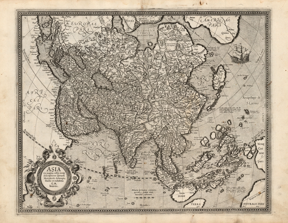
1595 Mercator Map of Asia: First Atlas Edition
Asia-mercator-1595-2$2,000.00


Title
Asia ex magna orbis terre. descriptione Gerardi Mercatoris desumpta studio et industria G. M. Iunioris.
1595 (undated) 14.75 x 18.25 in (37.465 x 46.355 cm) 1 : 25000000
1595 (undated) 14.75 x 18.25 in (37.465 x 46.355 cm) 1 : 25000000
Description
This is a fine first edition example of Gerard Mercator's 1595 map of Asia, the second map of the continent to appear in an atlas. It presents Asia as it was understood at the beginning of the Dutch effort to extend power into the Spice Islands, and at the dawn of the drive to discover alternative routes to the East Indies that would bypass the Portuguese stranglehold on the Asia trade. This map exhibits a fine early strike, with strong clear lines and bold paper/ink contrast.
A Closer Look
The map extends across the Pacific to include New Guinea, the Philippines, and part of North America. While the interior still contains place names and geographical features that would have been familiar to Strabo, Ptolemy, and Marco Polo, the coastline of Asia is filled with contemporary detail. The coastline of the subcontinent shows access to the best Dutch cartography of the late 16th century. The map includes parts of North America across the mythical 'Strait of Anian'. In addition to the place name Anian, America contains several other place names, notably Coronado's 'Quivira,' the hoped-for location of the legendary seven cities of gold. The southeast portion of the map includes Sumatra, a recognizable Malay Peninsula, and a reasonably well-informed treatment of the Philippines and the Spice Islands. Sri Lanka appears in its proper location and correct naming (Zeilam ins.) rather than the Ptolemaic Taprobana; a note assigns that name as the name for Sumatra known in antiquity. New Guinea appears in part, and in the lower right corner is a glimpse of 'Terrae Australis Pars': not, alas, an early glimpse of the modern continent of Australia, but the northern extent of the then-undiscovered and legendary terra Australis, or Antarctica. In the north, there is yet no note of Barentz's discoveries for the Dutch in and around Nova Zemlya, and a portion of Mercator's Terrae Polaris is illustrated (two of Mercator's four Arctic landmasses appear). Japan is shown in the early 'kite' form that appeared on Mercator's 1569 world map. Korea does not yet appear.A Superb Engraving
The map's rich array of place names are elegantly and clearly engraved, predominantly in the Italic font whose use in maps Mercator had pioneered. The map is embellished with a beautiful strapwork cartouche and a fine sailing ship appears ready to sail north between Asia and America. (A feat which would not be achieved until the 18th century - at the time this map was printed the separation of the two continents had not yet been established as fact.)Publication History and Census
This is the first edition of Mercator's Asia, appearing in the 1595 first edition of Mercator's Atlas. It would continue to appear in Hondius editions of the Atlas, despite the elder Jodocus Hondius having engraved a thoroughly updated version of the map in 1606. The verso text of the present example conforms with the first Atlas edition of 1595. We see sixteen examples of the separate map listed in OCLC.Cartographer
Gerard Mercator (March 5, 1512 - December 2, 1594) is a seminal figure in the history of cartography. Mercator was born near Antwerp as Gerard de Cremere in Rupelmonde. He studied Latin, mathematics, and religion in Rupelmonde before his Uncle, Gisbert, a priest, arranged for him to be sent to Hertogenbosch to study under the Brothers of the Common Life. There he was taught by the celebrated Dutch humanist Georgius Macropedius (Joris van Lanckvelt; April 1487 - July 1558). It was there that he changed him name, adapting the Latin term for 'Merchant', that is 'Mercator'. He went on to study at the University of Louvain. After some time, he left Louvain to travel extensively, but returned in 1534 to study mathematics under Gemma Frisius (1508 - 1555). He produced his first world map in 1538 - notable as being the first to represent North America stretching from the Arctic to the southern polar regions. This impressive work earned him the patronage of the Emperor Charles V, for whom along with Van der Heyden and Gemma Frisius, he constructed a terrestrial globe. He then produced an important 1541 globe - the first to offer rhumb lines. Despite growing fame and imperial patronage, Mercator was accused of heresy and in 1552. His accusations were partially due to his Protestant faith, and partly due to his travels, which aroused suspicion. After being released from prison with the support of the University of Louvain, he resumed his cartographic work. It was during this period that he became a close fried to English polymath John Dee (1527 - 1609), who arrived in Louvain in 1548, and with whom Mercator maintained a lifelong correspondence. In 1552, Mercator set himself up as a cartographer in Duisburg and began work on his revised edition of Ptolemy's Geographia. He also taught mathematics in Duisburg from 1559 to 1562. In 1564, he became the Court Cosmographer to Duke Wilhelm of Cleve. During this period, he began to perfect the novel projection for which he is best remembered. The 'Mercator Projection' was first used in 1569 for a massive world map on 18 sheets. On May 5, 1590 Mercator had a stroke which left him paralyzed on his left side. He slowly recovered but suffered frustration at his inability to continue making maps. By 1592, he recovered enough that he was able to work again but by that time he was losing his vision. He had a second stroke near the end of 1593, after which he briefly lost speech. He recovered some power of speech before a third stroke marked his end. Following Mercator's death his descendants, particularly his youngest son Rumold (1541 - December 31, 1599) completed many of his maps and in 1595, published his Atlas. Nonetheless, lacking their father's drive and genius, the firm but languished under heavy competition from Abraham Ortelius. It was not until Mercator's plates were purchased and republished (Mercator / Hondius) by Henricus Hondius II (1597 - 1651) and Jan Jansson (1588 - 1664) that his position as the preeminent cartographer of the age was re-established. More by this mapmaker...
Source
Mercator, G., Atlas sive cosmographicae meditationes de fabrica mundi et fabricati figura, (Amsterdam) 1595.
Mercator's Atlas is one of the most important works in the history of cartography. Although in fact Ortelius was the first to publish a proper atlas, the Teatrum Orbis Terrarum, Mercator's work the first book to employ the term Atlas for a collection of maps. The term is derived both from the mythical titan, Atlas, who was forced to bear the world upon his shoulders, and the Libyan king, philosopher, and astronomer of the same name that, so the legend goes, constructed the first globe. Mercator dedicated the final 25 years of his life to compile the Atlas. He published two parts during his lifetime in 1585 and 1589, but the final part published posthumously by his son Rumold Mercator, in 1595. The map plates for the Atlas were later acquired by Jodocus Hondius who published the most complete and well known edition in 1606. It was Jodocus who popularized the Atlas and who did the most to elevate Gerard Mercator's name.
Condition
Very good. Marginal mend at bottom, away from printed image; reinforced at upper centerfold. Some marginal soiling and a spot to lower right, else excellent with wide margins and a bold strike.
References
OCLC 36746150. Van der Krogt, P. C. J., Koeman's Atlantes Neerlandici, (Vol. 1), 8000:1A. Rumsey 10501.055.