
1754 Robert Sayer / George Foster Map of Asia. Rare, Separately Issued

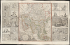
A new and correct map of asia Laid down from the latest and best Observations...
Separate-Issue Rarity. Vignettes illustrating Asian religous practices. 3 known examples.
- Digital Map Information
- Suitable for large format printing
- File Size: 71.88 MB
- File Type: ZIP / TIFF
- ICC color profile embedded
- Delivered instantly via download link
Separate-Issue Rarity. Vignettes illustrating Asian religous practices. 3 known examples.
This is an extremely rare, separately issued 1754 George Foster / Robert Sayer map of Asia. Although printed in 1754, the map's cartography dates to c. 1735, when it was first issued in a now-lost edition by the map seller George Foster. The map features elaborate decorative side panels, added in 1754 by Sayer, illustrating Asiatic religious practices. This map stands out for its remarkable rarity, being one of only 3 known surviving examples. It is also significant for its use of the term 'Sea of Corea' (Sea of Korea) to denote the sea between Japan and Korea, the naming of which is a matter of international contention.A Closer Look
This large map - printed to three sheets, and joined as issued - presents Asia from the East Indies in the south to the Waygats Strait in the north; it spans from Muscovy and Asia Minor in the west to Japan and the Strait of De Vries in the east. The northern part of the map is dominated by Muscovite Tartary. The south encompasses the Arabian Peninsula and reaches as far as the Marianas Islands (Ladrones). The Spice Islands and the Philippines are well-detailed. Notably, the body of water nestled between Japan, Korea, and the speculative Land of Iesso is termed the 'Sea of Corea'.The plates to the left and right of the map are comprised of an array of images depicting the regional religious practices, with emphasis on the variety of deities and idols worshipped.
Dating the Map
This map bears Robert Sayers' imprint, and was printed by his firm. It was not, however, composed by him. The engraver, William Roades, did not work for him and may not even have been alive by the time Sayer was operating. Roades, did, however, engrave several maps in the 1730s on behalf of map seller George Foster. These are thought to have included maps of the four continents, of which Robert Sayer acquired at least three - America, Africa, and Asia.Of these, only the map of America has survived in its 1738 first state; a few Sayer editions of the America map survive, with a long history of amendment: it is known to have been reprinted as late as 1794, and appears in at least 7 states. The Africa map survives only in one known copy of a Sayer edition, dated 1754.
The present map stylistically conforms to Foster's corresponding America and Africa maps in several key respects. It bears Roades' imprint and, like the Africa, it bears a dedication to George, Prince of Wales. This would have been among Sayer's changes to the map: at the time of Roades' work, the Prince of Wales was Frederick, George's father, and accordingly, the surviving 1738 America map was dedicated to Frederick. Further, the present work includes Sayer's address: opposite Fetter Lane, Fleet Street (fl. 1748 - 1766). These dates, and the dates in which George was Prince of Wales (r. 1751 - 1760), frame the period in which this map could have been produced. The 1754 date associated with the Sayer issue of the Africa map likely applies to this map, for they were certainly intended as a set.
The Africa and some of the America maps also include side panels similar to those appearing here. We suspect that these were added by Sayer. Surviving examples of Foster's 1738 America do not exhibit them. The vignettes remained in use as late as 1794 when they appear on the Laurie and Whittle edition of the America map.
Sea of Korea vs. Sea of Japan
The sea between Japan and Korea, whose name, either the 'Sea of Korea,' 'East Sea,' or the 'Sea of Japan,' is here identified in favor of Korea (Sea of Corea). Historically, Korea has used the term 'East Sea' since 59 B.C., and many books published before the Japanese annexed Korea make references to the 'East Sea' or 'Sea of Korea.' Over the centuries, neighboring and Western countries have identified Korea's East Sea using various terms. The St. Petersburg Academy of Sciences referred to the East Sea as 'Koreiskoe Mope' or 'Sea of Korea' in their 1745 map of Asia. Other 17th and 18th-century Russian maps alternate between 'Sea of Korea' and 'Eastern Ocean.' The 18th-century Russian and French explorers Adam Johan von Krusenstern and La Perouse called it the 'Sea of Japan,' a term that became popular worldwide. Nonetheless, the last official map published by the Russians name the East Sea the 'Sea of Korea.' The name is currently still a matter of historical and political dispute between the two countries.Publication History and Census
The map, engraved by William Roades for George Foster, was first produced as a c. 1738 separate issue. The plate was acquired by Robert Sayer c. 1754, who added the decorative panels before printing and offering the work, likewise as a separate issue. As a separate issue with no associated book or text publication, the map's survival rate is extremely low. No examples of the Foster edition of this map are known to have survived. We are aware of only two other examples of the present map: one in the collection of the King Abdulaziz Public Library, and another, spuriously dated, at Brown University. We have never seen another example on the market.Cartographers
Robert Sayer (1725 - January 29, 1794) was an important English map publisher and engraver active from the mid to late 18th century. Sayer was born in Sunderland, England, in 1725. He may have clerked as a young man with the Bank of England, but this is unclear. His brother, James Sayer, married Mary Overton, daughter-in-law of John Overton and widow of Philip Overton. Sayer initially worked under Mary Overton, but by December of 1748 was managing the Overton enterprise and gradually took it over, transitioning the plates to his own name. When Thomas Jefferys went bankrupt in 1766, Sayer offered financial assistance to help him stay in business and, in this way, acquired rights to many of the important Jefferys map plates as well as his unpublished research. From about 1774, he began publishing with his apprentice, John Bennett (fl. 1770 - 1784), as Sayer and Bennett, but the partnership was not formalized until 1777. Bennett retired in 1784 following a mental collapse and the imprint reverted to Robert Sayer. From 1790, Sayer added Robert Laurie and James Whittle to his enterprise, renaming the firm Robert Sayer and Company. Ultimately, Laurie and Whittle partnered to take over his firm. Sayer retired to Bath, where, after a long illness, he died. During most of his career, Sayer was based at 53 Fleet Street, London. His work is particularly significant for its publication of many British maps relating to the American Revolutionary War. Unlike many map makers of his generation, Sayer was a good businessman and left a personal fortune and great estate to his son, James Sayer, who never worked in the publishing business. Further Details...
George Foster (c. 1704 - 1752) was a British map and print seller, publisher and printer. Virtually nothing is known of his life, apart from the works he printed and some legal residue. By 1740 he was advertising his business selling 'a new map of ye West Indies, also a new map of St Sebastian, Gibraltar, & Portmahon, with great variety of the newest & best sort of maps & prints wholesale or retale.' in 1737, he is known to have produced maps of London, South Britain, England, and Wales. He is known with certainty to have produced, c. 1735, A new and correct map of America and A new and correct map of Africa ; these maps were engraved by William Roades, and were subsequently acquired by Robert Sayer, who added his own imprint and published further editions of them. A further map, A New and correct Map of Asia, engraved by Roades and published by Sayer, has surfaced; this is very likely a work produced by Roades for Foster. It may be presumed that Foster also produced similar maps of the World and Europe, but these have not survived. Further Details...
William Roades (fl. 1731 - 1740) was a British engraver operating in the first half of the 18th century. He was baptized in 1703; he was apprenticed to engraver and printseller Sutton Nicholls (1668 - 1729). He engraved maps for Thomas Bakewell in 1731. He engraved A new and correct map of America and A new and correct map of Africa ; these maps were also produced for George Foster, and were subsequently acquired by Robert Sayer, who added his own imprint and published further editions of them. A further map, A New and correct Map of Asia, engraved by Roades and published by Sayer, has surfaced; this is very likely a work produced by Roades for Foster. It may be presumed that Foster also produced similar maps of the World and Europe, but these have not survived. Further Details...
Condition
Very good. Reinforced splits at folds with some cracking and virtually no loss. Else excellent with original outline color.
References
OCLC 61997169. (misdated)