
This item below is out of stock, but another example (left) is available. To view the available item, click "Details."
Details
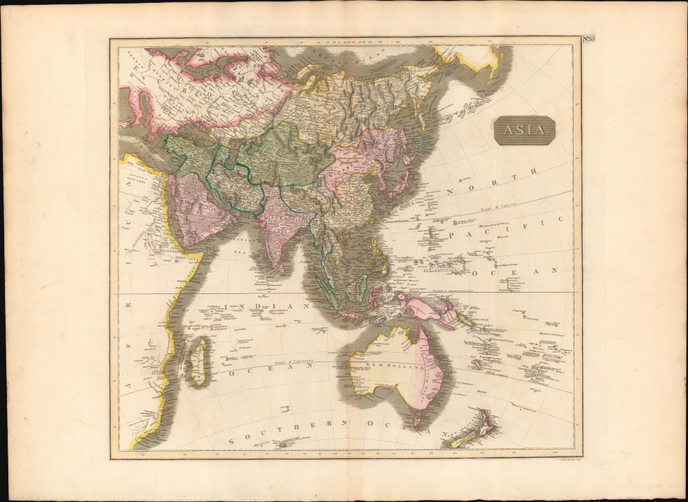
1814 Thomson Map of Asia and Australia
1814 (undated) $450.00
1814 Thomson Map of Asia and Australia
Asia-thomson-1814$225.00

Title
Asia.
1814 (undated) 18.75 x 20.75 in (47.625 x 52.705 cm)
1814 (undated) 18.75 x 20.75 in (47.625 x 52.705 cm)
Description
This fascinating hand colored 1814 map depicts Asia and Australia. The whole is beautifully engraved in the minimalist English style pioneered in the early part of the 19th century. Thomson maps are known for their stunning color, awe inspiring size, and magnificent detail. Thomson's work, including this map, represents some of the finest cartographic art of the 19th century. Relief is shown by hachure with towns, cities, and major topographical features identified.
By the early 18th century most of the world had been explored, but the notable exceptions are evident on this map. These include an uncertain shoreline in Northern Australia (here identified as New Holland), an extremely primitive and speculative mapping of New Guinea, and a largely unmapped African Interior. The Liakhov Islands, just north of Siberia, make one of their first cartographic appearances. These islands, discovered, but the Russian trader Ivan Liakhov, contained so much fossilized Mammoth Ivory that for nearly 100 years scientists speculated that the islands were in fact composed of Ivory.
Engraved in 1814 by J. and G. Menzies and issued as Plate no. 30 for Edinburgh cartographer John Thomson's 1817 issue of the New General Atlas.
Cartographer
John Thomson (1777 - c. 1841) was a Scottish cartographer, publisher, and bookbinder active in Edinburgh during the early part of the 19th century. Thomson apprenticed under Edinburgh bookbinder Robert Alison. After his apprenticeship, he briefly went into business with Abraham Thomson. Later, the two parted ways, John Thomson segueing into maps and Abraham Thomson taking over the bookbinding portion of the business. Thomson is generally one of the leading publishers in the Edinburgh school of cartography, which flourished from roughly 1800 to 1830. Thomson and his contemporaries (Pinkerton and Cary) redefined European cartography by abandoning typical 18th-century decorative elements such as elaborate title cartouches and fantastic beasts in favor of detail and accuracy. Thomson's principle works include Thomson's New General Atlas, published from 1814 to 1821, the New Classical and Historical Atlas of 1829, and his 1830 Atlas of Scotland. The Atlas of Scotland, a work of groundbreaking detail and dedication, would eventually bankrupt the Thomson firm in 1830, at which time their plates were sequestered by the court. The firm partially recovered in the subsequent year, allowing Thomson to reclaim his printing plates in 1831, but filed again for bankruptcy in 1835, at which time most of his printing plates were sold to A. K. Johnston and Company. There is some suggestion that he continued to work as a bookbinder until 1841. Today, Thomson maps are becoming increasingly rare as they are highly admired for their impressive size, vivid hand coloration, and superb detail. More by this mapmaker...
Source
Thomson, J. A New General Atlas, (Edinburgh) 1814.
Condition
Very good condition. Original centerfold exhibits some light toning . Light soiling to outer margins. Original platemark visible. Blank on verso.
References
Rumsey 1007.038. Phillips (Atlases) 731. Newberry Library: Ayer 135 T4 1817.