1814 Thomson Map of Asia and Australia
Asia-thomson-1814-2$450.00

Title
Asia.
1814 (undated) 18.75 x 20.75 in (47.625 x 52.705 cm) 1 : 35000000
1814 (undated) 18.75 x 20.75 in (47.625 x 52.705 cm) 1 : 35000000
Description
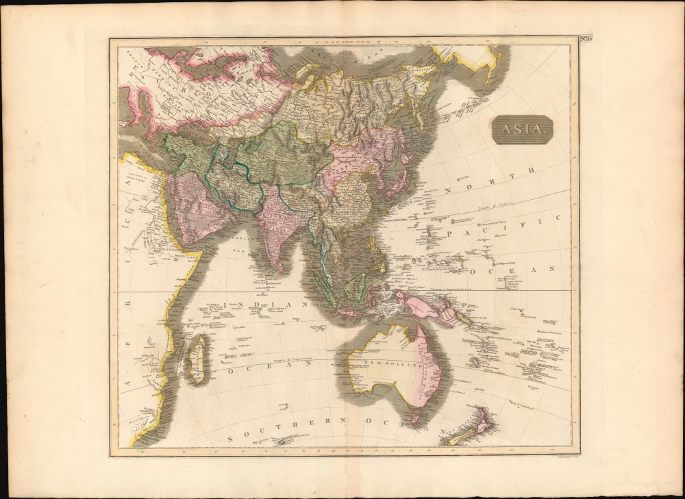
This is a first edition 1814 John Thomson map of Asia, the Indian Ocean, and Australia.
A Closer Look
Coverage embraces all of Asia, Australia, the Indian Ocean, and the western Pacific. Partial coverage includes adjacent parts of Africa, Europe, and America. Relief is shown by hachure with towns, cities, and major topographical features identified. Major spheres of influence are color-coded, including China, Chinese Tartary, West Tartary, Siberia, Persia, Hindoostan, Turkey, and Arabia. The inclusion of Australia and New Zealand are likely meant to put the entire region into the context of the Indian Ocean, the primary vector of maritime trade with Asia and the New South Whales Colony - points of great interest to the British public. Australia is neatly divided with shading between New Holland and New South Wales.Great Thibet
The map offers a novel illustration of 'Great Thibet', a vast territory including not only Tibet, but also Nepal, Bhutan, Burma, Siam (Thailand), and Malaya. Not only is Tibet here independent from China, it is also comparable in geographical significance to both China and India. It is not clear from where this vision of Tibet stems, although it is common to other contemporaneous British maps, including those of Cary and Pinkerton.Historical Context
By the early 18th century, most of the world had been explored, but notable exceptions are evident on this map. These include an uncertain shoreline in Northern Australia (here identified as New Holland), an extremely primitive and speculative mapping of New Guinea, and a largely unmapped African Interior. The Liakhov Islands, just north of Siberia, make one of their first cartographic appearances. These islands, discovered by the Russian trader Ivan Liakhov, contained so much fossilized Mammoth Ivory that for nearly 100 years, scientists speculated that the islands were fully composed of ivory.Publication History and Census
This map was prepared and engraved in 1814 in Edinburgh by J. and G. Menzies for inclusion in the 1817 first edition of John Thomson's New General Atlas.CartographerS
John Thomson (1777 - c. 1841) was a Scottish cartographer, publisher, and bookbinder active in Edinburgh during the early part of the 19th century. Thomson apprenticed under Edinburgh bookbinder Robert Alison. After his apprenticeship, he briefly went into business with Abraham Thomson. Later, the two parted ways, John Thomson segueing into maps and Abraham Thomson taking over the bookbinding portion of the business. Thomson is generally one of the leading publishers in the Edinburgh school of cartography, which flourished from roughly 1800 to 1830. Thomson and his contemporaries (Pinkerton and Cary) redefined European cartography by abandoning typical 18th-century decorative elements such as elaborate title cartouches and fantastic beasts in favor of detail and accuracy. Thomson's principle works include Thomson's New General Atlas, published from 1814 to 1821, the New Classical and Historical Atlas of 1829, and his 1830 Atlas of Scotland. The Atlas of Scotland, a work of groundbreaking detail and dedication, would eventually bankrupt the Thomson firm in 1830, at which time their plates were sequestered by the court. The firm partially recovered in the subsequent year, allowing Thomson to reclaim his printing plates in 1831, but filed again for bankruptcy in 1835, at which time most of his printing plates were sold to A. K. Johnston and Company. There is some suggestion that he continued to work as a bookbinder until 1841. Today, Thomson maps are becoming increasingly rare as they are highly admired for their impressive size, vivid hand coloration, and superb detail. More by this mapmaker...
John Menzies (October 27, 1772 - October 16, 1857) was a Scottish engraver active in Edinburgh during the late 18th and early 19th centuries. Menzies mastered engraving as an apprentice to James Rymer. In 1811, he partnered with his younger brother, George Menzies, to found the engraving firm of J. and G. Menzies, which was active until about 1831. Later his son, also named John, joined the firm and they engraved jointly under the imprint of J. Menzies and Son. At its height, the Menzies firm employed three men and three apprentices. Menzies engraved maps for Thomas Brown and John Thomson, among others. After his death, his son, John Menzies II (1819 – 1891), continued the family business until about 1891. Learn More...
Baldwin and Cradock (fl. c. 1810 - 1860) were London based publishers working in the early to mid 19th century. They are best known for their publication of the Society for the Diffusion of Useful Knowledge's ground breaking subscription atlas. They also published John Thomson's magnificent New General Atlas from 1814 - c. 1820. In addition to their cartographic corpus, the firm had wide ranging publishing interests in many other areas, including books, broadsides, and an investment in Blackwoods Magazine. They had their offices at 47 Paternoster Row, London, England. This firm also published under the imprint Baldwin, Cradock, and Joy and Cradock and Joy. Learn More...
Source
Thomson, J., A New General Atlas, (Edinburgh: Baldwin, Cradock, Joy) 1817.
Condition
Very good. Original centerfold exhibits some light toning. Light soiling to outer margins. Original platemark.
References
Rumsey 1007.038. Phillips (Atlases) 731. Newberry Library: Ayer 135 T4 1817.