This item has been sold, but you can get on the Waitlist to be notified if another example becomes available, or purchase a digital scan.
1570 Ortelius Map of Asia (first edition)
AsiaeNovaDescriptio-ortelius-1570$1,250.00

Title
Asiae Nova Descriptio
1572 (undated) 15 x 20 in (38.1 x 50.8 cm)
1572 (undated) 15 x 20 in (38.1 x 50.8 cm)
Description
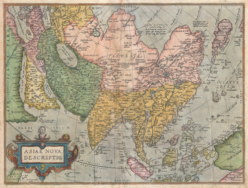
A scarce and stunning first edition example of Abraham Ortelius' important 1572 map of Asia. Covers from Europe and Africa eastward to include all of Asia, the East Indies, Japan, and parts of New Guinea and Australia. From west to east, this map offers numerous elements worthy of further study. The Caspian Sea, according to the convention of the time, is presented on an east-west rather than north-south axis. Arabia is projected in a distended form. Further east in western China, Cayamay lacus is depicted. This mythical body of water was postulated by Ortelius to be the source great rivers of Southeast Asia. Indeed, Ortelius crisscrosses East Asia with a vast network of waterways advocating his belief that a water route existed through China to the North Sea and hence, via the Northeast Passage, to Europe. Still further east Japan appears in a distorted top heavy projection that resembles a tadpole. To the south Luzon is absent from the Philippine Islands. In the extreme southeast portion of the map Australia appears as 'Terrae Incognitae Australis.' East of China, two sailing ships ply the waters of the Pacific. A large decorative title cartouche adorns the lower left hand quadrant.
Ortelius based this map on his own wall map of 1567. This map was issued as page 3 in the 1872-73 German language edition of Ortelius's Theatrum Orbis Terrarum and corresponds to Van den Broecke's Ort 6 classification, predating the more common Ort 7 map of Asia that appeared in 1574. Ortelius printed only 1675 copies of this edition of Asiae Nova Descriptio (Ort 6) as opposed to nearly 7000 of the 1574 (Ort 7) edition
Ortelius based this map on his own wall map of 1567. This map was issued as page 3 in the 1872-73 German language edition of Ortelius's Theatrum Orbis Terrarum and corresponds to Van den Broecke's Ort 6 classification, predating the more common Ort 7 map of Asia that appeared in 1574. Ortelius printed only 1675 copies of this edition of Asiae Nova Descriptio (Ort 6) as opposed to nearly 7000 of the 1574 (Ort 7) edition
Cartographer
Abraham Ortelius (April 14, 1527 - June 28, 1598) also known as Ortels, was a cartographer, geographer, and cosmographer of Brabant, active in Antwerp. He was the creator of the first modern atlas, Theatrum Orbis Terrarum and is a seminal figure in the history of cartography. Along with Gerard Mercator and Gemma Frisius, he was a founder of the Netherlandish school of cartography. His connections with Spain - culminating in his 1575 appointment as Royal Cartographer to King Phillip II of Spain - gave him unmatched access to Spanish geographical knowledge during a crucial period of the Age of Discovery. Ortelius was born in 1527 in Antwerp. In 1547 he entered the Antwerp Guild of Saint Luke as an illuminator of maps. He began trading in books, prints, and maps, traveling regularly to the Frankfurt book and print fair, where in 1554 he met Mercator. He accompanied Mercator on journeys throughout France in 1560 and it was at this time, under Mercator's influence, that he appears to have chosen his career as a scientific geographer. His first published geographic work appeared in 1564, an eight-sheet cordiform world map. A handful of other maps preceded the 1570 publication of the first edition of the Theatrum Orbis Terrarum, which would prove to be his life work. Appearing with but 53 maps in its first edition, Ortelius' work expanded with new maps added regularly. By 1592, it had 134 maps. Many of Ortelius' maps remained the standard for nearly a century. He traveled extensively, but his genius was as a compiler, locating the best informed maps on which to base his own. His contacts throughout Europe and extending even (via the Portuguese) to the Far East were formidable. Moreover, many of his maps were based on his own scholarship, particularly his historical works. His theories of geography were particularly ahead of his time with respect to the notion of continental drift, the possibility of which he mused on as early as 1596, and which would be proven correct centuries later.
In a sense his greatest achievement was his successful navigation of the religious and political violence endemic to his city throughout his adult life: The Dutch Revolt, or Eighty Years' War (1568 - 1648), fully embroiled Antwerp. Although outwardly and officially recognized as Catholic (Arias Montanus vouched for Ortelius' Catholic orthodoxy prior to his appointment as Royal Geographer), Ortelius was able to separate himself from the religious furor which characterized the war in the low countries. Ortelius showed a glimpse of himself in a letter to a friend, regarding humanist Justus Lipsius: 'I do not know whether he is an adherent of the Pope or a Calvinist, but if he has ears to hear, he will neither be one nor the other, for sins are committed on both sides'. Ortelius' own explorations of Biblical history in his maps, and the Christogram contained in his own motto, suggest him to be a religious man, but his abjuration of political religious authorities mark him as an individualist. His tombstone at St Michael's Præmonstratensian Abbey in Antwerp bears the inscription, Quietis cultor sine lite, uxore, prole. ('served quietly, without accusation, wife, and offspring.') More by this mapmaker...
Source
Ortelius, A., Theatrum Orbis Terrarum, (1572 German language edition)
Condition
Very good condition. Light overall toning. Minor discoloraiton on original centerfold. Minor centerfold reinforcement on verso - bottom center, extening about 2 inches into the map.
References
Phillips (Atlases) 374. Library of Congress, Map Division, G1006 .T5 1570b. Van den Broecke, M., Ortelius Atlsa Maps: An Illustrated Guide, Ort 6, 1572/1573G3 (see also the very similar but more common Ort 7). Koeman, C., Atlantes Neerlandici…, 3. Tibbets G. R., Arabia in Early Maps, map 34, p. 48. Schilder,G. The Wall Maps by Abraham Ortelius p. 93-124. Heintz. M. & Reiter, C. Asiæ Descriptio and the Judgment Day Painting, p. 125-132. Suarez, T., Early Mapping of South-East Asia, p. 164-170. Lutz, W., Japan: A Cartographic Vision: European Printed Maps from teh early 16th to the19th Century, 11C. Quirino, C., Philippine Cartography,1320-1899, p. 76. Clancy, R., The Mapping of Terra Australis, 1.12. Yeo, J., Mapping the Continent of Asia, #5. Van Der Krogt, Peter C. J., Koeman's Atlantes Neerlandici, AN: 8000:31A. Cortazzi, H., Isles of Gold: Antique Maps of Japan, pl. 19.