This item has been sold, but you can get on the Waitlist to be notified if another example becomes available, or purchase a digital scan.
1703 Christoph Cellarius Map of Asia Minor
AsiaMinor-cellarius-1703$150.00

Title
Asia Minor.
1703 (undated) 10 x 14.25 in (25.4 x 36.195 cm) 1 : 3620000
1703 (undated) 10 x 14.25 in (25.4 x 36.195 cm) 1 : 3620000
Description
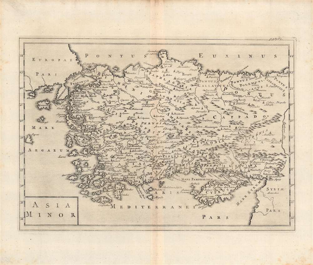
This is a c. 1703 map of Asia Minor by Christoph Cellarius' published in his Notitia Orbis Antiqui, Sive Geographia Plenior.... Cellarius was an expert on ancient languages and history, and this work employs the Latinized names of ancient Anatolian territories and kingdoms.
A Closer Look
This map shows the ancient territories of Asia Minor, or Anatolia plus the islands of the eastern Mediterranean and the westernmost portion of the Levant. Ancient towns, city-states, and kingdoms are indicated, along with mountains and rivers. As the historical text which this map accompanied ended with the rise of Constantine, the map does not indicate Constantinople but instead shows more ancient towns (Chrysopolis and Chaldecon) that were later incorporated into the metropolis.Publication History and Census
This map was included in Cellarius' Notitia Orbis Antiqui, Sive Geographia Plenior..., a two-volume work of history of Ancient Rome from the start of the Republic up to the time of Constantine. Notitia Orbis Antiqui was published throughout the 18th century, making dating this example difficult. However, it is likely from an early edition of Cellarius' work, as later editions added a vignette illustration at bottom-left. Some other minor differences are evident in later editions, such as the addition of an island or extension of the Greek mainland just south of Scyros and different lettering (Europae instead of Evropae). Early editions of the map and its parent work are both quite rare, with the map lacking any catalog listing in the OCLC and the early editions of Notitia Orbis Antiqui being held by a handful of institutions in Europe.Cartographer
Christoph Cellarius (1638 - 1707) or, more commonly, Christopher Keller was a German scholar, historian and textbook publisher working in the later part of the 17th century. Cellarius is known to have been born in Schmalkalden and to have held academic positions in both Weimar and Halle. C. Cellarius's most important contribution was his 1683 publication of A Universal History Divided into an Ancient, Medieval, and New Period. It was in this work that the concept of history as divisible into three distinct periods (Ancient History, Mediaeval History, and Modern History) was introduced. Likely Cellarius never understood the impact that his structured system of historical nomenclature would have on the way future historians would interpret the past. Christopher Cellarius should not be confused with the more widely known cosmographer Andreas Cellarius More by this mapmaker...
Source
Cellarius, C., Notitia orbis antiqui sive geographia plenior..., Vol. 1, (Leipzig), 1703.
Condition
Good. Fold line visible. Minor foxing in the margins.