This item has been sold, but you can get on the Waitlist to be notified if another example becomes available, or purchase a digital scan.
1704 De Fer / Van Loon Map of Asia
Asie-defer-1705$750.00

Title
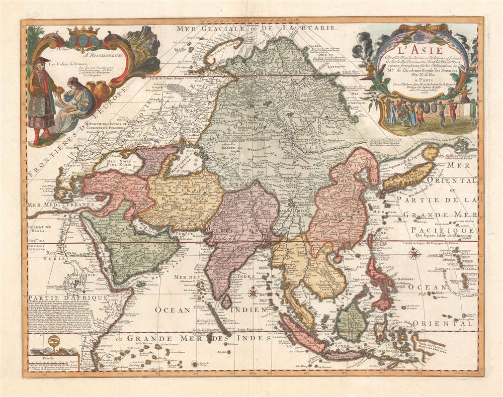
L'Asie dressée selon les dernières relations et suivant les nouvelles découvertes dont les points principaux sont placés sur les observations de Mrs. de l'Académie Royale des Sciences par N. de Fer.
1705 (dated) 20 x 26 in (50.8 x 66.04 cm) 1 : 30000000
1705 (dated) 20 x 26 in (50.8 x 66.04 cm) 1 : 30000000
Description
A scarce 1705 separate issue Nicolas De Fer map of Asia dedicated to the children of France. The map features two decorative cartouches engraved by N. Guerard. Coverage on an unusual conical projection extends from the Mediterranean to the Philippine Archipelago (Archipel de St. Lazare), and from Nova Zembla to Java. The map embraces many of the confusions and misconceptions regarding the geography of Asia prevalent during the late 17th and late 18th centuries, among them a mismapping of the Caspian Sea, the apocryphal lake of Chiamay, and confusion regarding the seas north of Japan and the Siberian Arctic.
Curious Mapping of the Siberian Arctic
The map is most striking for its unique illustration of northeastern Asia. While Hokkaido is correctly separated from the mainland, the coast west of Korea runs sharply east suggesting a connection to the mainland of North America. Predates widespread European knowledge of Sakhalin and Kamchatka. The Siberian Arctic coast reappears further north from the mouth of the River Amur, leaving considerable confusion regarding the cartographer's option regarding the northeast passage.Apocryphal Lake Chiamay
The mythical Lake of Chiamay appears at the western extreme of the map, roughly in what is today Assam, India. Early cartographers postulated that such a lake must exist to source the four important Southeast Asian river systems: the Irrawaddy, the Dharla, the Chao Phraya, and the Brahmaputra. This lake began to appear in maps of Asia as early as the 16th century and persisted well into the mid-18th century. Its origins are unknown but may originate in a lost 16th century geography prepared by the Portuguese scholar Jao de Barros. It was also heavily discussed in the journals of Sven Hedin, who believed it to be associated with Indian legend that a sacred lake, Mansarovar, linked several of the holy subcontinent river systems. There are even records that the King of Siam led an invasionary force to take control of the lake in the 16th century. Nonetheless, the theory of Lake Chiamay was ultimately disproved and it disappeared from maps entirely by the 1760s.Publication History and Census
This map was engraved by Harmanus van Loon and first issued by Nicolas De Fer in 1700. The present example is the second edition, issued in 1705. Other than the date, there are no clear differences between these two early editions. The plates were subsequently acquired by Guillaume Danet and revised considerably, adding scales to the upper left cartouche, for republication in 1722. This map was separately issued, but incorporated into a number of De Fer composite atlases in the early 18th century.CartographerS
Nicholas de Fer (1646 - October 25, 1720) was a French cartographer and publisher, the son of cartographer Antoine de Fer. He apprenticed with the Paris engraver Louis Spirinx, producing his first map, of the Canal du Midi, at 23. When his father died in June of 1673 he took over the family engraving business and established himself on Quai de L'Horloge, Paris, as an engraver, cartographer, and map publisher. De Fer was a prolific cartographer with over 600 maps and atlases to his credit. De Fer's work, though replete with geographical errors, earned a large following because of its considerable decorative appeal. In the late 17th century, De Fer's fame culminated in his appointment as Geographe de le Dauphin, a position that offered him unprecedented access to the most up to date cartographic information. This was a partner position to another simultaneously held by the more scientific geographer Guillaume De L'Isle, Premier Geograph de Roi. Despite very different cartographic approaches, De L'Isle and De Fer seem to have stepped carefully around one another and were rarely publicly at odds. Upon his death of old age in 1720, Nicolas was succeeded by two of his sons-in-law, who also happened to be brothers, Guillaume Danet (who had married his daughter Marguerite-Geneviève De Fer), and Jacques-François Bénard (Besnard) Danet (husband of Marie-Anne De Fer), and their heirs, who continued to publish under the De Fer imprint until about 1760. It is of note that part of the De Fer legacy also passed to the engraver Remi Rircher, who married De Fer's third daughter, but Richer had little interest in the business and sold his share to the Danet brothers in 1721. More by this mapmaker...
Harmanus van Loon (fl. c. 1690 - c. 1725) was a Flemish engraver active in Paris during the late 17th and early 18th centuries. Van Loon worked primarily in Paris and often signed his work, which includes maps and other engravings for such prominent cartographers as Nicolas de Fer, Jean Baptiste Nolin, Guillaume Delisle, and others. There is some speculation that he may have been related to the Brussels born painter Theodorus van Loon. Learn More...
Condition
Very good. Full color.
References
Rumsey 10022.009.