This item has been sold, but you can get on the Waitlist to be notified if another example becomes available, or purchase a digital scan.
1867 Hughes Map of Athens and Part of Attica (Boeotia, Phocis) in Ancient Greece
AthensAttica-hughes-1867$50.00

Title
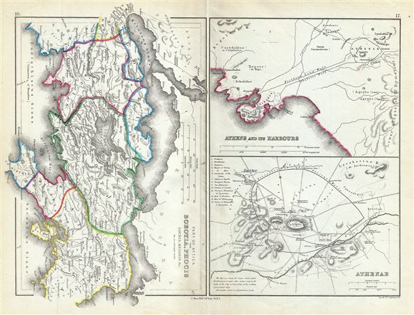
Part of Attica with Boeotia, Phocis Locris, Megaris etc.
1867 (undated) 10 x 13 in (25.4 x 33.02 cm) 1 : 800000
1867 (undated) 10 x 13 in (25.4 x 33.02 cm) 1 : 800000
Description
This is a fascinating 1867 map of Athens along with parts of Attica, including Boeotia and Phocis in ancient Greece, by William Hughes. Essentially three maps on a single sheet, the first map covers Attica in ancient Greece from the Malian Gulf to the Gulf of Corinth and includes Boeotia, Phocis, Lochris and Megaris. Ancient Greek cities, including Plataea, Thebes, Athens, Magara, are identified. The map notes several roads, towns and cities and uses both contemporary and ancient names - an invaluable resource for scholars of antiquity.
The two maps in the second half of the sheet detail the city of Athens and its vicinity. The top map details Athens and its harbors. Athens, capital of the Athenian Empire, was the heart of Ancient Greek culture and the quintessential Ancient Greek city state. It was here that Greek philosophy and literature as well as the concept of democracy first evolved. This plan of Athens, based on excavations and ancient sources offers impressive and accurate detail. The Northern Long Wall and the Phaleric Wall, build to protect merchants as they passed from Athens to the port city of Piraeus are noted. Also includes the Academy of Plato.
The lower map in the second half of the sheet depicts the city of Athens. Covering the walled center of ancient Athens, this map details the ancient city's most important buildings and monuments. It names the Lyceum (Aristotle's famous school of philosophy), the Pnyx (where assemblies of the people were held) and the Cynosarges (Public gymnasium) as well as Arcopolis, the Temple of Theseus, and the Areopagus. A key in the upper left quadrant identifies 14 other ancient sites.
This map was created by William Hughes, printed by J. Bien and engraved by G.E. Sherman, for issued as plates 16 and 17 in Sheldon and Company's An Atlas of Classical Geography.
CartographerS
William Hughes (c. 1818 - May 21, 1876) was a cartographer, engraver, lithographer, printer, and publisher active in London during the middle part of the 19th century. Hughes enjoyed and long and varied cartographic career. He was elected a Fellow of the Royal Geographical Society in 1838 and, from about 1840, taught geography and mapmaking at St. Johns College for Civil Engineers. He later taught the same at both Queens College and Kings College, London. For a time he was employed as a map librarian for the British Museum. Hughes began engraving maps around 1839 and worked with most of the prominent British map and atlas publishers of his era, including but not limited to Charles Knight, A. and C. Black, George Philip, William Cassell, and others. More by this mapmaker...
Julius (Julien) Bien (September 27, 1826 - December 21, 1909) was a German-Jewish lithographer and engraver based in New York City. Bien was born in Naumburg, Germany. He was educated at the Academy of Fine Arts, Cassell and at Städel's Institute, Frankfurt-am-Main. Following the suppression of the anti-autocratic German Revolutions of 1848, Bien, who participated in the pan-German movement, found himself out of favor in his home country and joined the mass German immigration to the United States. Bien can be found in New York as early as 1849. He established the New York Lithographing, Engraving & Printing Company in New York that focused on the emergent chromo-lithograph process - a method of printing color using lithographic plates. His work drew the attention of the U.S. Government Printing Office which contracted him to produce countless government maps and surveys, including the Pacific Railroad Surveys, the census, numerous coast surveys, and various maps relating to the American Civil War. Bien also issued several atlases both privately and in conjunction with a relation, Joseph Bien. At the height of his career Bien was elected president of the American Lithographers Association. After his death in 1909, Bien's firm was taken over by his son who promptly ran it into insolvency. The firm was sold to Sheldon Franklin, who, as part of the deal, retained the right to publish under the Julius Bien imprint. In addition to his work as a printer, Bien was active in the New York German Jewish community. He was director of the New York Hebrew Technical Institute, the New York Hebrew Orphan Asylum, and president of the B'nai B'rith Order. Learn More...
Sherman and Smith (fl. c. 1829 - 1855), sometimes working as Stiles, Sherman & Smith, were American engravers active in New York City during the middle part of the 19th century. The firm including John Calvin Smith (surveyor and engraver), George E. Sherman, and sometimes, Samuel Stiles. Their work primarily focused on government publications, including the maps and engravings prepared to illustrate the official records of the 1838-42 United States Exploring Expedition (U.S. Ex. Ex.), maps issued for the Army Corps of Topographical Engineers, and various U.S. Coast Survey Charts. They also engraved privately for Thomas Bradford and John Disturnell, among others. Sherman and Smith maintained offices at the corner of Broadway and Liberty Street in New York City and were highly regarded as the finest cartographic engravers in the city. Their non-cartographic legacies include George Inness, who apprenticed with them for two years before going on to become a well regarding American landscape painter of the Hudson River School. Learn More...
Source
Sheldon and Company, An Atlas of Classical Geography constructed by William Hughes and edited by George Long, (New York) 1867.
Condition
Very good. Minor wear and toning along original centerfold.