This item has been sold, but you can get on the Waitlist to be notified if another example becomes available, or purchase a digital scan.
1912 Kauffman Map of Atlanta, Georgia
Atlanta-kauffman-1912$1,750.00

Title
Map of the City of Atlanta Georgia.
1912 (dated) 27.5 x 26.25 in (69.85 x 66.675 cm) 1 : 20000
1912 (dated) 27.5 x 26.25 in (69.85 x 66.675 cm) 1 : 20000
Description
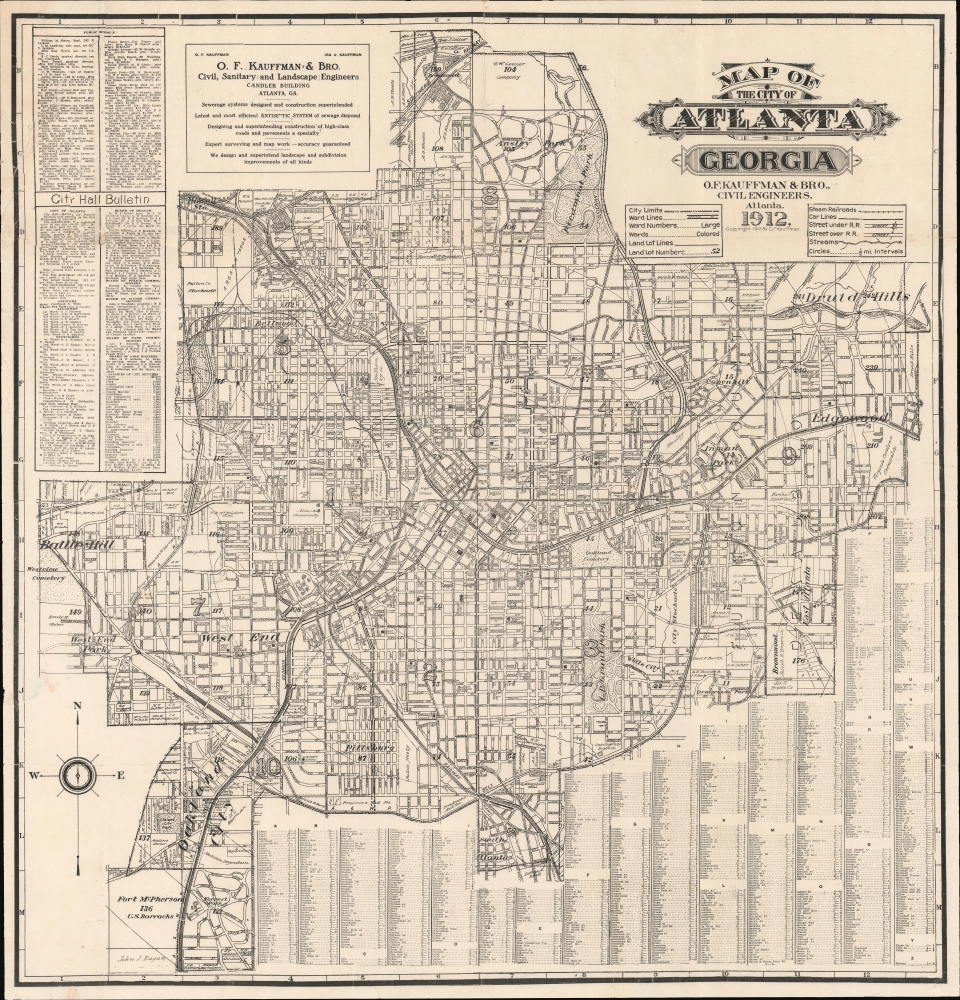
This is the 1912 O. F. Kauffman map of Atlanta, Georgia, the earliest obtainable detailed map of that city. The map emerged during a period of growth and urbanization as Atlanta transformed into a manufacturing and transport hub. It is also significant for its delineation, for one of the first times on a commercial map, Atlanta's many historically black schools and universities.
A Closer Look
The map is centered on Union Depot, underscoring Atlanta's origins as a railroad town. Circles radiate from the center in roughly half-mile intervals. Streets, businesses, schools, parks, large private estates, and more are labeled. This map incorporates many new development surveys compiled between 1906 and 1911, including Druid Hills, Edgewood, Ansley Park, West End, Battle Hill, Oakland City, Pillsbury, Bellwood, and others. A comprehensive street index occupies the lower right, while the upper right lists public schools, includes a digest of municipal notes, and names city offices, including salaries (the Construction Chief, at 4,000 USD /year, roughly 130,000 USD today, is the most highly paid .)Mapping African American Education in Atlanta
In the early 20th-century, Atlanta was a significant center for African American education and intellectual thought, thanks to its historically black colleges and the efforts of the African American community to establish and maintain educational institutions. This map marks several important African American schools and colleges, herein named for the first time on a commercial map, including Atlanta University (Atlanta Clark), the first historically black college in the southern United States; Spelman Seminary College, the oldest private historically black liberal arts institution for women; and Morris Brown College, the first educational institution in Georgia to be owned and operated entirely by African Americans. Morehouse, located in West End, is slightly outside of the scope of this map.Historical Context: Mapping of Atlanta
In terms of the historical mapping of Atlanta, we note only few earlier maps. The earliest is the original 1853 subdivision map for the Atlanta City Council. This was followed by several small-scale maps published in the 1870s for Hanleiter's Directory of Atlanta. The city council published a new map in 1877. Atlanta went through a period of rapid expansion in the early 20th century, with numerous new suburban developments, many surveyed by Kauffman. Nonetheless, we see no subsequent general maps until this map of 1912, which was followed by updated maps by Kauffman, his brother Ira, and Ira's sons, from 1921 to the 1940s.Publication History and Census
This map was published in 1912 by Orrin Frederick Kauffman's firm, O.F. Kauffman and Brother. It is rare and has no market history, although we do see examples at the Kenan Research Center at the Atlanta History Center and another example at the University of Georgia. We note latter editions of this map from the 1920s and 1930s, some published by Ira U. Kauffman. There are no other records of the present map, and this is the first time it has appeared on the private market.CartographerS
Orrin Frederick Kauffman (March 14, 1876 - October 5, 1930) was an Atlanta, Georgia, based civil engineer. He was born in Baughman Township, Wayne, Ohio. He is alternately identified as 'Orsen' or 'Aaron'. Orrin moved to Atlanta around 1899 to work for the Title Guarantee and Trust Company. There, in 1901, he married Gertrude Evangeline Curtis, described as a 'woman of unusual beauty'. Around 1906, Orrin founded the civil engineering firm O.F. Kauffman and Brother with Ira Ulysses Kauffman (1881 - 1937). The firm is known for surveying many of Atlanta's suburbs, including Druid Hills, Ansley Park, and Avondale Estates (where he lived in a gracious southern mansion). Kauffman fell ill around 1929 and appears to have retired from O.F. Kauffman, as in that year, his brother and partner founded I. U. Kauffman and Son. Further disturbed by domestic troubles, his wife Gertrude (Curtis) Kauffman filed for divorce two weeks prior; Kauffman committed suicide by poison in his offices in the Chandler Building on October 5, 1930. The largest collection of Kauffman's regional surveys are held at Emory University. More by this mapmaker...
Ira Ulysses Kauffman (May 18, 1881 - December 27, 1937) was an American civil engineer. Born in Massalon, Ohio, Kauffman moved to Atlanta, Georgia, in 1903, where he worked with his brother Orrin Frederick Kauffman (1876 - 1930) in the engineering firm O.F. Kauffman and Brother. Orrin suffered health and personal problem starting in 1929, leading to his suicide in 1930. Likely he retired from the business sometime in 1929, as in that year, Ira opened his own engineering firm with his son in 1929 called I.U. Kauffman and Son, which would later become I.U. Kauffman and Sons, and later the Southern Map Company. At the time of his death, Kauffman worked as chief engineer of the Georgia division of the United States Coast and Geodetic Survey. Over the course of his career, Kauffman helped lay out the Druid Hills, Ansley Park, and Avondale Estates developments, as well as the Camp Gordon and Fort Benning army posts. Kauffman died unexpectedly of a cerebral hemorrhage. One of Kauffman's sons, William R. Kauffman (April 19, 1911 - December 19, 1978), served in the U.S. Navy Seabees in the South Pacific for thirty months during World War II. After being discharged from the Navy, William Kauffman founded an engineering firm in Atlanta called Kauffman and Harman. Learn More...
Condition
Good. Laid down on archival tissue to stabilize old fold splits. Minor reinstatement here and there at some fold intersections and other points.
References
University of Georgia, Hargrett Map Collection (hmap1912k3).