1942 Richard Edes Harrison Map of the World during World War II
Atlantic-harrison-1942$300.00

Title
Atlantic Arena. A Fortune Map. Orthographic Series I.
1942 (dated) 21 x 26.5 in (53.34 x 67.31 cm) 1 : 25000000
1942 (dated) 21 x 26.5 in (53.34 x 67.31 cm) 1 : 25000000
Description
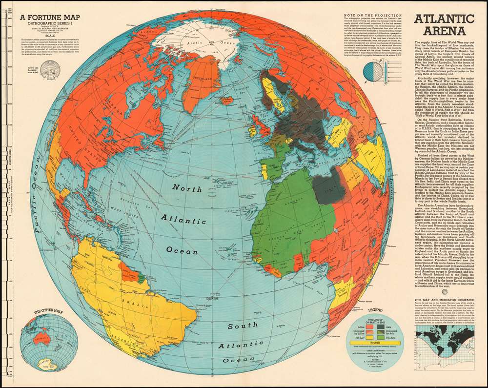
This is a June 1942 Richard Edes Harrison orthographic map of the Atlantic theatre of World War II, intended to reinforce American support for actively prosecuting the war in Europe. Centered on the North Atlantic, the map shows all of North America and the Atlantic coastlines of South America, Africa, and Europe. The map's intent is to emphasize the growing importance of the Atlantic theatre to an American public whose attention had been held by the Pacific theatre of the war. A key entitled 'The Line-Up on May 10, 1942' indicates how color is used on the map to identify the affiliation the nations shown. Red for the Allies and black for the Axis, gradations of those colors to indicate occupied countries, gold for pro-Ally nations and green for pro-Axis. Yellow indicates neutral nations. While the sporting reference of 'The Line-Up' might be glib, the strong implication is not only that sides exist in the conflict, but that they are unavoidable: 'true neutral' nations are vastly outnumbered by active players in what can easily be seen is a World War. The depicted sea routes, with the distances between key cities serve to emphasize the immediacy of the European conflict for Americans. Despite the apparently great Atlantic distances, routes between New York and Europe are dwarfed by the vast expanses of ocean lying between the North American west coast and Japan. The immediacy of the European theatre is being emphasized here. These were important points to drive home: while America's war throughout 1942 had been primarily fought in the Pacific, change was in the air. In the Atlantic, the German U-Boat war was going through a disturbing period of success. Britain was fighting Germany and Italy in North Africa. But at the same time, the first American forces were finding their way east: Air Corps bases had by May been established in the UK, and the first U.S. ground forces (including the 1st Armored Division) had been committed to Ireland. While the United States had been galvanized for war against Japan following Pearl Harbor, public support for a European war was less sanguine.
The Projection
The map employs a unique orthographic projection, which, as Harrison himself notes on the map,is the most nearly pictorial of all formal projections... its infinite viewpoint makes it possible to show a full hemisphere... (It) has been neglected as a serious map because of its extreme variations in scale (a disadvantage it shares with Mercator) and because only half the world can be shown at one time (a disadvantage that it shares with the globe). However, these faults (and the nature of maps requires them all to have faults) can be forgiven because of its graphic delineation of the sphere. R.E.H.There are two inset maps: one titled 'The Other Half', which depicts the antipodes of the main map: Australia, Japan, China, Southeast Asia, the South Pacific, and Antarctica. and the other, titled 'This Map and Mercator Compared' shows the portion of the world visible on the orthographic projection marked in black on Mercator's venerable grid. Harrison's plumby discussion of the pros and cons of the projection make the use of the map more friendly, and perhaps add authority to the map's propagandistic content. In any case, the maps were clearly popular with Fortune's readership: this map would be just the first in a series of 'news maps' for both Fortune and the U.S. Government, intended to clarify the complex events of the war and make them comprehensible and palatable to the voting public.
Publication History and Census
This map was first published in 1942 as an insert in Fortune Magazine. It is well represented in institutional collections, with 25 listings in OCLC. It was included in the 1944 collection of Harrison's maps, 'Look At The World: The Fortune Atlas For world Strategy' (this later state includes a 1944 copyright on the verso.)Cartographer
Richard Edes Harrison (1902 - January 5, 1994) was an American cartographer and cartoonist active in the middle part of the 20th century. Harrison is credited with redefining cartography, especially journalistic cartography, by employing spherical perspective, bold shading, and graphic design to both make maps more publicly accessible and give them an artistic dimension. Harrison was born in Baltimore and studied design at Yale, graduating in 1923, before relocating to New York City at the height of the Great Depression. He made ends meet through industrial design work, creating everything from bottles to ashtrays. His first foray into the cartographic world was a fill-in job at Fortune magazine. The editors at Fortune must have admired his work for it launched a long-standing collaboration. His work, doubtless inspired by the age of air travel, became exceptionally popular during World War II, where his unique approach and political charged subject matter illustrated the seats of war with exceptional poignancy and clarity. After the war, Harrison continued to produce maps from his base in New York City. In his spare time he was an avid ornithologist and was commonly seen in Central Park in search of rare bird sightings. More by this mapmaker...
Source
FORTUNE, June 1942.
Condition
Excellent condition. Blank on verso.
References
Rumsey 11086.000. OCLC 225430406.