
1650 / 1659 Jan Jansson Map of the Atlantic Ocean

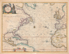
Mar del Nort.
Beautifully Engraved Chart of the Atlantic.
- Digital Map Information
- Suitable for large format printing
- Full resolution TIFF file
- ICC color profile embedded
- Delivered instantly via download link
Beautifully Engraved Chart of the Atlantic.
This is Johannes Janssonius's 1650 Mar del Nort, a decorative sea chart of the North Atlantic. Covering from Dutch New Netherland to the Caribbean and the shores of Europe and Africa, the map presents the ocean at the center of an expanding maritime world. Elaborate cartouches, a dense network of rhumb lines, and the phantom islands of Brasil and Buss combine the elegance of Dutch Golden Age engraving with the uncertainties of early oceanic exploration.A Closer Look
Coverage extends from Hudson Strait, southern Greenland, and Iceland to the Equator, encompassing eastern North America, the Gulf of Mexico, the Caribbean, northern South America, western Europe, and western Africa. Bermuda, the Azores, Madeira, the Canaries, and the Cape Verde Islands punctuate the open ocean, while extensive stippling identifies the banks around Newfoundland.Coastal names crowd the continental margins, emphasizing ports, river mouths, capes, and islands. A central compass rose anchors the intersecting rhumb lines, underscoring the map's maritime focus.An elaborate title cartouche occupies the upper left, accompanied by a hunter with a bow, a winged putti, and an assortment of animals. A second cartouche, supported by putti, encloses the scale in German miles.
New Netherland and the American Coast
New Netherland receives prominent treatment along the northeastern seaboard, with Fort Orange identified inland on the Hudson River. This Dutch trading post, established in 1624 at present-day Albany, anchors the map's depiction of the colony. Virginia lies to the south, while New France, Quebec, Acadia, and Newfoundland appear farther north.The contrast between coastal detail and inland uncertainty is particularly apparent around the St. Lawrence. Its waters connect with a loosely rendered network of rivers and elongated lakes, rather than a recognizable depiction of the Great Lakes. Farther north, the designation Meta Incognita identifies Baffin Island.
Phantom Islands of the Atlantic
Among the chart's most intriguing details are two apocryphal phantom islands. Brasil appears southwest of Ireland, perpetuating the legendary Atlantic island associated with Irish folklore. Despite repeated failures to locate it, Brasil remained a fixture of European maps for centuries.Farther northwest, 'Bus' represents Buss Island, reportedly sighted by sailors returning from Martin Frobisher's third expedition in 1578. Jansson depicts it as a substantial, though indistinctly mapped, island south of Iceland.
Publication History and Census
This chart was first published in Amsterdam in 1650 in Janssonius's Atlantis Majoris Quinta Pars, Orbem Maritimum, the fifth volume of his Atlas Novus. Its maritime section contained 23 maps and represented an important early effort to assemble charts of the world's oceans for a general atlas readership. The map was issued in a single state, but appeared in various editions of Jansson and Visscher atlases through the second half of hte 17th century. The present example is from the 1650 Latin edition of Jansson's Atlantis Majoris…. Institutional holdings include the David Rumsey Map Collection at Stanford University and the W. H. Pugsley Collection at McGill University, among others.Cartographer
Jan Jansson or Johannes Janssonius (1588 - 1664) was born in Arnhem, Holland. He was the son of a printer and bookseller and in 1612 married into the cartographically prominent Hondius family. Following his marriage, he moved to Amsterdam, where he worked as a book publisher. It was not until 1616 that Jansson produced his first maps, most of which were heavily influenced by Blaeu. In the mid-1630s, Jansson partnered with his brother-in-law, Henricus Hondius, to produce his important work, the eleven-volume Atlas Major. About this time, Jansson's name also begins to appear on Hondius reissues of notable Mercator/Hondius atlases. Jansson's last major work was his issue of the 1646 full edition of Jansson's English Country Maps. Following Jansson's death in 1664, the company was taken over by Jansson's brother-in-law Johannes Waesberger. Waesberger adopted the name of Jansonius and published a new Atlas Contractus in two volumes with Jansson's other son-in-law, Elizée Weyerstraet, with the imprint 'Joannis Janssonii Haeredes' in 1666. These maps also refer to the firm of Janssonius-Waesbergius. The name of Moses Pitt, an English map publisher, was added to the Janssonius-Waesbergius imprint for maps printed in England for use in Pitt's English Atlas. Further Details...
Source
Jansson, J., Atlantis Majoris Quinta Pars Orbem Maritimum seu Omnium Marium totius Orbis Terrarum Navigationibus hodierno tempore frequentatorum descriptionem accuratisimam continens : cui adjunctus est Orbis Antiquus et Graecia Parallela, (Amsterdam: Jansson) 1650.
Condition
Very good. Mended centerfold splits at top and bottom.
References
Rumsey 10056.007. Phillips 5944. New York Public Library, b15315219. OCLC 1124469373. Burden, P., The Mapping of North America,# 290. Van der Krogt, P. C. J., Koeman's Atlantes Neerlandici, (3 Vols), #0101:1.