This item has been sold, but you can get on the Waitlist to be notified if another example becomes available, or purchase a digital scan.
1787 Christoph Gottlieb von Murr Map of the Western Hemisphere of Martin Behaim
Atlantic-murrbehaim-1787$1,500.00

Title
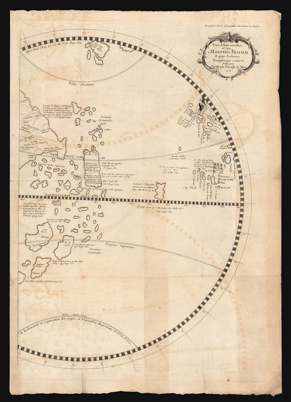
Pars Globi terrestris Ao. 1492. Martino Behaim Equite Lusitano Norimbergae confecti. Delineavit Christoph. Theoph. de Murr. 1778.
1787 (dated) 22 x 15.25 in (55.88 x 38.735 cm)
1787 (dated) 22 x 15.25 in (55.88 x 38.735 cm)
Description
This fascinating and unique map, printed in 1787, is one of the earliest acquirable representations of the western hemisphere as it appeared on the oldest surviving globe - Martin Behaim's Erdapfel, a manuscript globe produced in Nuremberg in 1492. Behaim's globe was influential and fascinating, offering a glimpse on the imagined form of the world at the time of Columbus. Behaim's fame, amplified by supporters over the following centuries, led some to scholars to suppose he himself traveled across the Atlantic to America, or at least that supplied the theory to Columbus that the Atlantic route to the East Indies was navigable. The present map, copied from the western hemisphere of Behaim's globe by the historian Christoph Gottlieb von Murr, was produced as evidence that Behaim had neither stolen a march on Columbus, nor guided him. Having marshaled his evidence, von Murr says that 'history, and the globe destroy absolutely all these so - called facts, and prove (Behaim) had no knowledge of America.'
The western half of the map is dominated with the geographical reports of Marco Polo. The island of Japan (or Cipangu) is here presented as the wealthiest island of the Orient. Elsewhere are placed nutmeg forests, pepper forests, and Marco Polo's reports of mermaids. Turning his critical eye to these details, von Murr said of Behaim that 'he only passes on the stories that have been made to him, and which he is content to transcribe.'
In 1778, Christoph Gotlieb von Murr published Diplomatische Geschichte des portugiesischen beriihmten Ritters Martin Behaims, a methodical and authoritative refutation of Wagenseil based on an exhaustive scrutiny of the historical record, up to and including not only Behaim's globe but also the Behaim family archives. This Nuremberg imprint included the first plate of this map of the Western Hemisphere as depicted on the Behaim globe, thoroughly annotated to connect with von Murr's text. The article was seized upon, translated and republished in to French (1787) and Spanish (1794). There were several editions printed in 1801 and 1802. The plate was not reused, but instead the map was re-engraved for each edition: the differences in pagination for each edition of the work required that the map itself have significant changes, as it contained numerous references to specific pages in von Murr's text.
Geographical Details
The western hemisphere, as conceived on Behaim's globe, extends from Madeira and Grand Canary Island to China and Java. Much is imaginary, or at best legendary. For example, the islands known as the Manilas were described as having such extreme magnetism that ships carrying iron could not safely navigate there. In the far north there appears an island noted as a source of white falcons: this island would be correctly identified on other, later maps as Iceland. The Azores, Cape Verdes, and Canary Islands appear with some accuracy. The central portion of the map features the imaginary islands of Antilia and St. Brendan.The western half of the map is dominated with the geographical reports of Marco Polo. The island of Japan (or Cipangu) is here presented as the wealthiest island of the Orient. Elsewhere are placed nutmeg forests, pepper forests, and Marco Polo's reports of mermaids. Turning his critical eye to these details, von Murr said of Behaim that 'he only passes on the stories that have been made to him, and which he is content to transcribe.'
Martin Behaim and his Globe
The Nuremberg native Behaim moved swiftly to establish himself as a textile merchant in Flanders. His meteoric rise continued: by 1484 he had become a successful merchant in Portugal, and by 1485 he was a courtier, a supposed expert in navigation and astronomy, and knighted by Portugal's John II. He married in Portugal in 1486, and thereafter took part in a voyage to west Africa. During a three-year return to Nuremberg beginning in 1490, he was financed by the city council to produce a globe. The 21-inch globe, painted by Georg Glockendon the Elder, was completed in 1492. The globe contains more than two thousand place names, is filled with illustrations, coats of arms, and text. The globe presented no evidence that its author had any inkling of the Americas. For one, its scale was predicated on the assumption that Claudius Ptolemy's measurement of the globe's size was correct. (It was not, Ptolemy having underestimated the size of the planet by more than a quarter). In this error Behaim was not alone among early mapmakers. Indeed, it is easy to look at Behaim's globe and understand why Columbus thought a western route might be feasible: From the Azores, or further south from the Cape Verde Islands, the space of ocean separating the European mariner from Japan seems much more manageable than the route around Africa. But there is no historical evidence that Columbus and Behaim ever spoke or corresponded. Instead, the globe's content reflects more the reports of Marco Polo, John Mandeville, and Diogo Gomes, while lacking more current Portuguese geographic data which presumably would have been available to Behaim as an 'expert' in navigation and a trusted courtier.A Persistent Geographical and Historical Argument
Behaim's contribution to cartography, whatever it might have been, fell out of sight for many years. In 1682, a professor of the university of Altdorf - Johann Christoph Wagenseil - delivered and published a eulogy for a descendant of Behaim, in which he granted the 15th century Behaim the laurels for 1) the discovery of America prior to Columbus; and 2) the discovery of the Strait of Magellan, prior to Magellan himself. Wagenseil proposed that Behaim's alleged achievements brought honor to Nuremberg in particular and Germany in general. In his panegyric, Wagenseil complained thatenormous fame has transported the names of Columbus and Magellan throughout all regions of the world with great fanfare, yet not [that of] our countryman, although he is deserving of a rank at least equal to that of the gods of the seas.From this point onwards, Wagenseil’s claims provided a basis for later historians' connecting Behaim and Columbus (particularly in Germany, where the myth of a German hero found fertile ground.)
In 1778, Christoph Gotlieb von Murr published Diplomatische Geschichte des portugiesischen beriihmten Ritters Martin Behaims, a methodical and authoritative refutation of Wagenseil based on an exhaustive scrutiny of the historical record, up to and including not only Behaim's globe but also the Behaim family archives. This Nuremberg imprint included the first plate of this map of the Western Hemisphere as depicted on the Behaim globe, thoroughly annotated to connect with von Murr's text. The article was seized upon, translated and republished in to French (1787) and Spanish (1794). There were several editions printed in 1801 and 1802. The plate was not reused, but instead the map was re-engraved for each edition: the differences in pagination for each edition of the work required that the map itself have significant changes, as it contained numerous references to specific pages in von Murr's text.
Publication History and Census
The present example of this oft-reprinted map was printed for the 1787 French translation of von Murr's work, included in the Recueil des Pieces interessantes concernant les Antiquites, les Beaux-Arts, les Belles-Lettres, et la Philosophie. We have not seen this edition appear on the market, and this printing of the separate map is not catalogued in OCLC, although the Recueil appears to be well-catalogued in institutional collections.CartographerS
Martin Behaim (October 6, 1459 - July 29, 1507) was a German textile merchant, traveler and cartographer. He was sufficiently convincing to have become an advisor to John II of Portugal on matters of navigation, and today he is best known for having produced, in 1492, the world's oldest surviving globe. He was born in Nuremberg to the elder Martin Behaim, also a merchant and a senator of the city, and Agnes Schopper. His education is not known, despite his own (unsupported) contention that he was a student of the mathematician and astronomer Regiomontanus. In 1474 at the age of fifteen he was sent to Flanders to apprentice as a textile merchant. Five years later, he moved to Antwerp to be closer to the center of that trade, also relying on Nuremberg contacts in that city to become established. In 1484, however, he made a move to Lisbon. His specific motives are unknown. But if he wished to benefit from the new trade opening to Africa in spices, slaves, and gold he could scarcely have made a better choice. He thrived, becoming a counselor in the court of King John II. It is supposed that he advised the court on navigation and astronomy, but we have no evidence that he had any such expertise to offer, or that he made any such contributions. It is deeply unlikely that he could have taught the Portuguese anything that they were not already expert in. The seventeenth-century historian Johann Christoph Wagenseil made the claim in 1682 that Behaim had discovered America before Columbus, and others suggested that he at least gave Columbus the idea of sailing west. These claims are not supported by evidence; as early as 1778 these claims were being vigorously refuted by the scholar Christoph Gottlieb von Murr. Claims that Behaim accompanied Diogo Cão on a voyage of discovery, and Pigafetta’s claim that Magellan had knowledge from Behaim of a strait to the Pacific are also suspect. It is more likely that he became a supplier of scientific and astronomic instruments, for which his hometown of Nuremberg was renowned. Whatever his contributions to the Portuguese court actually were, they were appreciated: on February 28, 1485 Behaim was knighted by John II. It is supposed that later that year he took part in a voyage to West Africa, probably on a trade voyage led by João Afonso de Aveiro. He married in Portugal in 1486, and settled on Portuguese island of Faial in the Azores, where his father-in-law, Josse van Huerter, was Captain-donatário and leader of the Flemish community. The necessity of settling a will brought him back to Nuremberg In 1490, where he would remain for three years. It is during this time that he encouraged the production of the globe – the ‘Erdapfel’ - for which he is now famous. 1493 saw his return to the Azores, where he would remain. An unfortunate business trip to Lisbon in 1507 found him in the hospice of Saint Bartholomew, where he died. More by this mapmaker...
Christoph Gottlieb von Murr (August 6, 1733 – April 8, 1811) was German polymath and scholar, living and working in Nuremberg. A historian and magistrate, he was prolific in print, appearing in many journals during his life. His writings extended to natural science, art history, and on the history of early libraries and books, both manuscripts and incunables. He was a vigorous correspondent and maintained a large library of his own. His early life is not known; he studied at was for the law, on its completion he instead began work as a historian. Many of his published works focused on the history of his native city, as well as its literature and art. Though himself a Protestant, he had become familiar with the Jesuits and wrote about the order and its 1773 suppression. He also reprinted, in 1790, Michael Servetus’ banned 1553 work Christianismi restitutio, burned when its author was condemned to the stake. He published in 1778 – and then continued to publish, in various journals and in several languages – a detailed refutation of the claims (initially floated by the 17th century historian Wagenseil) that Martin Behaim, and not Columbus and Vespucci, had been the first European discoverer of the Americas. It was in the service of this article, in its many translations, that von Murr produced what remains the first large-scale reproduction of part of the famous Behaim globe, and the only such available to today’s collector. Learn More...
Source
Murr, C. G. von, 'Notice Sur le Chevalier Martin Behaim, Celebre Navigateur Portugais. Avec la Description de son Gloibe terrestre' in Recueil de pièces intéressantes concernant les antiquités, les beaux-arts, les belles-lettres et la philosophie, traduites de différentes langues, (Paris: Barrois) 1787.
Condition
Very good. Marginal mend away from printed image. Some offsetting and few stains, else excellent.
References
OCLC 829554968.