1934 Dolph and Stewart City Plan or Map of Atlantic City, New Jersey
AtlanticCity-dolphstewart-1934$800.00

Title
Map of Atlantic City Ventnor, Margate and Longport New Jersey.
1934 (undated) 16.25 x 37.75 in (41.275 x 95.885 cm) 1 : 18000
1934 (undated) 16.25 x 37.75 in (41.275 x 95.885 cm) 1 : 18000
Description
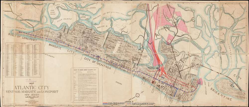
This is a c. 1934 Dolph and Stewart city plan or map of Atlantic City, New Jersey, and its immediate environs highlighting trolley routes in the area. The map depicts the region from the Borough of Longport to Brigantine and from Belvidere Place to the Atlantic Ocean, including Ventnor and Margate. Manuscript notations trace the trolley routes in different colors and a manuscript legend along the bottom border identifies the operators. Intriguingly, both the Atlantic City and Longport Branch of the West Jersey and Seashore Railroad and the Atlantic City and Shore Railroad, popularly known as the Shore Fast Line, are crossed out in pencil and labeled as the Atlantic City Transportation Company. We have been unable to unearth a concrete history for the Atlantic City Transportation Company. The red lines trace the Pennsylvania-Reading Seashore Lines, which operated in New Jersey from 1933 until 1976, and was jointly-owned by the Pennsylvania Railroad and the Atlantic City Railroad.
The Plan Itself - Piers, Hotels, and the Boardwalk
Within the plan itself, individual streets are illustrated and labeled, along with the municipal airport, the high school, and the train station. Atlantic City's celebrated piers are labeled, including the Steel Pier, the Steeplechase Pier, and the St. Charles Garden Pier. Numerous hotels, including the Ritz-Carlton and the Ambassador (which evoke the luxury associated with parts of Atlantic City), are illustrated as well. The boardwalk runs from along the Absecon Inlet along the Atlantic Coast to Margate. A street index appears on the left side and a text box presents information about the city.The Atlantic City of 'Monopoly'
Capturing, as it does, Atlantic City's streets and railroads as of 1934, this plan reveals the city that informed Charles Darrow's choices of street, utility and railroad names for the game 'Monopoly' in the form in which Parker Brothers first marketed the game in 1935. Thus, despite most people never having set foot in the city itself, very many will associate these streets with interminable nights culminating in fabulous imaginary wealth, or crushing imaginary bankruptcy.Publication History and Census
This map was published c. 1934 by Dolph and Stewart. This is the only known surviving example of the Dolph and Stewart map. It was then repurposed by the Pennsylvania Railroad to highlight trolley lines in the region, with particular focus placed on the Pennsylvania-Reading Seashore Lines. With the addition of the manuscript notations, this piece is a one-of-a-kind find offering a glimpse into Atlantic City's storied past.Cartographer
Frank B. Dolph (October 3, 1897 - November 26, 1975) was an American businessman and map publisher. Born in Great Neck, Long Island, New York, Dolph served as a Navy storekeeper during World War I. He began selling maps in 1919 after returning from England, likely for the George F. Cram Company, where he ultimately became an administrative aide. He also worked for the Rand McNally Company for some time before he founded his own map publishing firm, Dolph and Stewart, with his friend, sometime in the 1920s. Dolph and Stewart made maps throughout the 1920s and 1930s until they sold the firm in 1945 when Dolph decided to return to Florida. Dolph opened a new map publishing business, the Frank B. Dolph Map Co. in Ft. Lauderdale and published city plans of cities throughout the United States. Many of his maps were distributed by Chambers of Commerce or sold at newsstands. Real estate developers greatly appreciated his maps, those published by both the Dolph and Stewart Company and the Frank B. Dolph Company. Dolph retired as president of his firm around 1965, when he handed the business off to his son, Frank B. Dolph, Jr. Dolph worked with cartographer Theodore M. Politano for decades while operating the Frank B. Dolph Map Company. More by this mapmaker...
Condition
Very good. Dissected and mounted on linen in eighteen (18) panels. Exhibits some toning. Manuscript notations mark trolley lines in Atlantic City and its environs.