This item has been sold, but you can get on the Waitlist to be notified if another example becomes available, or purchase a digital scan.
1902 Mueller Map of Atlantic City and Absecon Island, New Jersey
AtlanticCity-mueller-1902$325.00

Title
Map of Atlantic City and Absecon Island.
1902 (dated) 13.25 x 40.5 in (33.655 x 102.87 cm) 1 : 14400
1902 (dated) 13.25 x 40.5 in (33.655 x 102.87 cm) 1 : 14400
Description
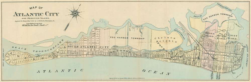
This is a rare 1902 August Henry Muller map of Absecon Island, including Atlantic City, issued in 1902. The map was published the year of Absecon's official incorporation as a city, making it one of the earliest obtainable separate issue maps of Atlantic City, Ventor, and Margate. The map is oriented to the northwest and covers all of Absecon Island from Great Egg Harbor Inlet to Absecon Inlet. The Boardwalk and Casino district of Atlantic City appears at right, with Youngs Ocean Pier, Auditorium Pier, Atlantic City Steel Pier, and Heinz Pier noted. Although long predating the casino period, Atlantic City in 1902 was still a hot spot for tourists. It offered luxurious grand hotels, the famous Boardwalk, sport fishing, spacious beaches, and golf. The Pennsylvania Railroad offered easy access connecting Atlantic City to both New York and Philadelphia. Quieter residential districts spread to the west, most offering commodious beach front real-estate that connects to the 'action' of Atlantic City via a convenient tram network.
Publication History and Census
This map was printed in Philadelphia by August H. Mueller, of 530 Locust Street. It was prepared to illustrate the 20th century souvenir edition of Heston's Hand Book [of] Atlantic City, published in 1902. Alfred M. Heston was, at the time, City Comptroller of Atlantic City. He issued his guide in many editions, but it was not until the city's incorporate in 1902 and subsequent first formal survey, that it included a large format map, as here. Scarce to the market.Cartographer
August Henry Mueller (December 1, 1857 - April 1, 1926) was a German-American printer, publisher, and lithographer based in Philadelphia, Pennsylvania. Mueller was born in Philadelphia to German immigrant Adam Mueller. He was educated primarily in public schools before apprenticing as a lithographer. Mueller lived for a time in Philadelphia, before, meeting with considerable success, he acquired a stately home 'Romar-Florem' in nearby Narberth, PA. He served as Narberth's burgess (Mayor) from 1895 to1897. He is listed as a lithographer in Philadelphia directories as early as 1880 and continued to issue maps and county atlases until his death. Mueller died in his home in Narberth from a heart attack. More by this mapmaker...
Source
Heston's Hand Book Atlantic City Illustrated, (Philadelphia: Mueller) 1902.
Condition
Very good. Left margin extended. Printed on 'onion-skin' paper. Minor soiling on old fold lines.
References
OCLC 1045956054.