1890 U. S. Hydrographic Office Chart of the U.S. Atlantic Coast
AtlanticCoast-hydrographicoffice-1890$1,500.00


Title
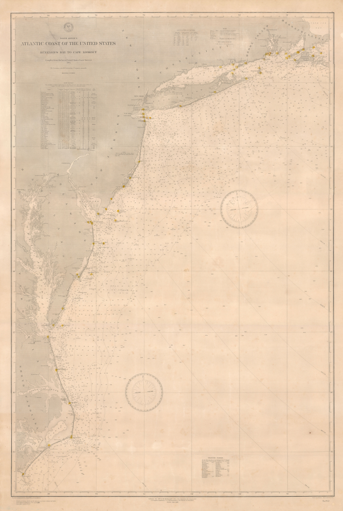
North America Atlantic Coast of the United States Buzzard's Bay to Cape Lookout.
1890 (dated) 46.5 x 31.5 in (118.11 x 80.01 cm) 1 : 800000
1890 (dated) 46.5 x 31.5 in (118.11 x 80.01 cm) 1 : 800000
Description
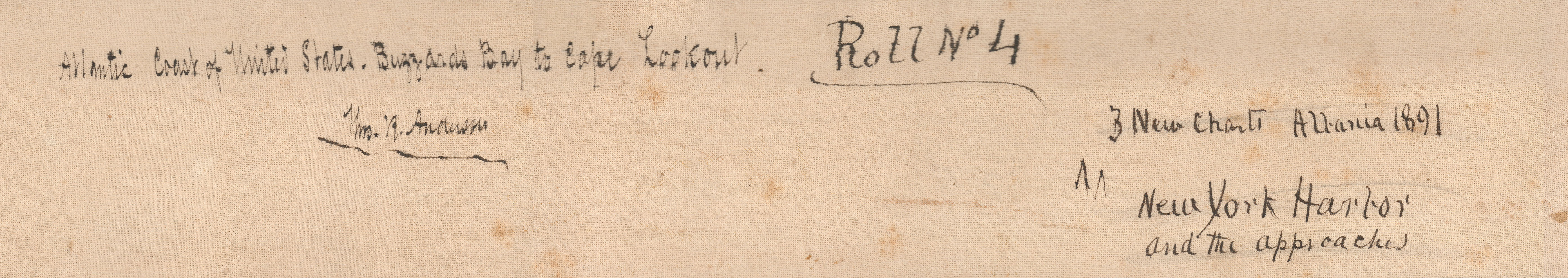
This is a rare large-format 1890 nautical chart of the Atlantic Coast of the United States prepared by the U.S. Hydrographic Office. Among other interesting features, the chart has a very clear provenance, having been purchased by Captain Thomas R. Anderson for use aboard the ship Albania.
Initially under the command of one Yates, Mr. Anderson became captain in 1891, the same year the chart was purchased. As a sail ship rather than a steamer, the Albania had become somewhat outdated by the mid-1890s, though its use into that decade is a reminder that steam power did not immediately displace sail power once it became available. For more information on the Albania and its captain Anderson, see Peter Ennals' 1999 article 'Business for Ships is Miserable Dull: A New Brunswick Mariner Confronts the Waning Days of Sail' in The Northern Mariner, a publication of the Canadian Nautical Research Society and the North American Society for Oceanic History.
A Closer Look
The map covers from Buzzards Bay and Martha's Vineyard at top to the Outer Banks and Cape Lookout in the south. Soundings are provided all along the coast, out to a distance of several hundred miles in some places. The locations of lighthouses are marked with red dots within yellow circles (several of these, such as those at Cape Hatteras and Currituck Beach, had been badly damaged in the U.S. Civil War and were only rebuilt in the 1870s). Additional navigational information on shoals, bottoms, magnetic compass variations, buoys, and hazards is also included. Supplementary tables on symbols for different types of buoys, bottoms, a complete list of coastal lighthouses with their range and other characteristics, and weather signals are provided in marginal areas, as are two large compass roses.Provenance - the Albania
The chart contains faint pencil annotations within and to the northeast of the top compass rose, strongly suggesting use aboard a ship. Indeed, a note on the linen backing of the chart mentions that it was one of three purchased in 1891 by Thomas Reese Anderson, the Canadian captain of the ship Albania (built 1884 and registered in Saint John, New Brunswick), for use in this case for the approaches to New York Harbor. Newspaper records of the era indicate that the Albania was used for trans-Pacific cargo shipments in the mid-late 1880s and early 1890s, primarily between Yokohama or Hyogo (Kobe) and New York, though it also stopped at other ports such as Calcutta and Java (Jakarta).Initially under the command of one Yates, Mr. Anderson became captain in 1891, the same year the chart was purchased. As a sail ship rather than a steamer, the Albania had become somewhat outdated by the mid-1890s, though its use into that decade is a reminder that steam power did not immediately displace sail power once it became available. For more information on the Albania and its captain Anderson, see Peter Ennals' 1999 article 'Business for Ships is Miserable Dull: A New Brunswick Mariner Confronts the Waning Days of Sail' in The Northern Mariner, a publication of the Canadian Nautical Research Society and the North American Society for Oceanic History.
Publication History and Census
This chart was drawn by Jean Baptiste Leon Dessez and engraved by Henry C. Evans for the U.S. Hydrographic Office, compiling information from the U.S. Coast Survey. Initially prepared in 1884 and published in 1885, this example updates navigational information to 1890. This chart is rare; we are only aware of one other example, an 1889 edition, held by the Norman B. Leventhal Map and Education Center at the Boston Public Library.CartographerS
United States Hydrographic Office (1866 - 1962) was a brach of he U.S. Navy that prepared and published maps, charts, and nautical books to aid in navigation. Before the establishment of the Hydrographic Office in 1866, U.S. navigators were almost entirely dependent on British charts. There had been a few private enterprises that had prepared and published charts, but none had been able to do so profitably. The Office was established 'for the improvement of the means of navigating safely the vessels of the Navy and of the mercantile marine, by providing, under the authority of the Secretary of the Navy, accurate and cheap nautical charts, sailing directions, navigators, and manuals of instructions for the use of all vessels of the United States, and for the benefit and use of navigators generally.' This way the Navy Department could furnish navy and merchant ships with charts illustrating the results of surveys and explorations undertaken by naval officers. The charts were priced to cover the cost of paper and printing alone, not preparation. Its main objective was to survey foreign coasts, as the Coast and Geodetic Surveys were responsible for surveying domestic waters. The Hydrographic Office was transferred from the Department of the Navy to the Department of Defense in 1949 and was replaced by the Naval Oceanographic Office in 1962. More by this mapmaker...
Jean Baptiste Leon Dessez (March 30, 1825 - May 17, 1895) was a French-born American civil engineer, surveyor, and hydrographer. Dessez's family were staunch royalists who only through luck managed to escape being guillotined during the French Revolution. Later, the family befriended and supported Napoleon Bonaparte. Jean Baptiste Leon Dessez, better simply known as Leon Dessez, emigrated to the United States in his youth and trained as a civil engineer. He was working in North Carolina when the U.S. Civil War began and he sided with the Confederacy, building fortifications around Richmond. Despite having joined the Confederacy, Dessez moved to Washington, D.C. after the war and spent the remained of his career at the U.S. Hydrographic Office. Learn More...
The Office of the Coast Survey (1807 - present) founded in 1807 by President Thomas Jefferson and Secretary of Commerce Albert Gallatin, is the oldest scientific organization in the U.S. Federal Government. Jefferson created the "Survey of the Coast," as it was then called, in response to a need for accurate navigational charts of the new nation's coasts and harbors. The spirit of the Coast Survey was defined by its first two superintendents. The first superintendent of the Coast Survey was Swiss immigrant and West Point mathematics professor Ferdinand Hassler. Under the direction of Hassler, from 1816 to 1843, the ideological and scientific foundations for the Coast Survey were established. These included using the most advanced techniques and most sophisticated equipment as well as an unstinting attention to detail. Hassler devised a labor intensive triangulation system whereby the entire coast was divided into a series of enormous triangles. These were in turn subdivided into smaller triangulation units that were then individually surveyed. Employing this exacting technique on such a massive scale had never before been attempted. Consequently, Hassler and the Coast Survey under him developed a reputation for uncompromising dedication to the principles of accuracy and excellence. Unfortunately, despite being a masterful surveyor, Hassler was abrasive and politically unpopular, twice losing congressional funding for the Coast Survey. Nonetheless, Hassler led the Coast Survey until his death in 1843, at which time Alexander Dallas Bache, a great-grandson of Benjamin Franklin, took the helm. Bache was fully dedicated to the principles established by Hassler, but proved more politically astute and successfully lobbied Congress to liberally fund the endeavor. Under the leadership of A. D. Bache, the Coast Survey completed its most important work. Moreover, during his long tenure with the Coast Survey, from 1843 to 1865, Bache was a steadfast advocate of American science and navigation and in fact founded the American Academy of Sciences. Bache was succeeded by Benjamin Pierce who ran the Survey from 1867 to 1874. Pierce was in turn succeeded by Carlile Pollock Patterson who was Superintendent from 1874 to 1881. In 1878, under Patterson's superintendence, the U.S. Coast Survey was reorganized as the U.S. Coast and Geodetic Survey (C & GS) to accommodate topographic as well as nautical surveys. Today the Coast Survey is part of the National Oceanic and Atmospheric Administration or NOAA as the National Geodetic Survey. Learn More...
Condition
Very good. Original linen backing. Even toning. Minor surface scuffing near title.
References
OCLC 950525600. Ennals, P., ''Business for Ships is Miserable Dull:' A New Brunswick Mariner Confronts the Waning Days of Sail' The Northern Mariner Vol. 9, No. 2.