This item has been sold, but you can get on the Waitlist to be notified if another example becomes available, or purchase a digital scan.
1814 Thomson Map of Atlantic Islands: Cape Verde, Canary, Madeira, Azores
AtlanticIslands-thomson-1814-2$150.00

Title
Atlantic Islands.
1814 (dated) 20.25 x 24 in (51.435 x 60.96 cm)
1814 (dated) 20.25 x 24 in (51.435 x 60.96 cm)
Description
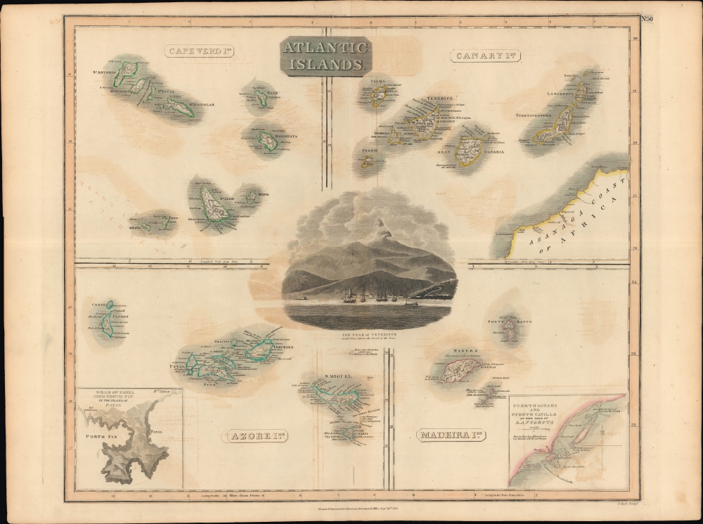
A hand colored 1814 map by John Thomson depicting the Atlantic islands of Cape Verde, the Canary Islands, Madeira, and the Azores, with insets of the ports of Fayal and Lancarota (Lanzarote). Though magnets of tourism today, in the 19th century and earlier, these islands were essential steppingstones on the trans-Atlantic shipping lanes between Europe and America.
These islands were crucial in the 15th and 16th centuries as stepping stones to the exploration of the New World. The Portuguese, in particular, mastered methods of navigation and tested out means of economic exploitation on the islands, including monocrop plantations worked by slave laborers from western Africa. By the 19th century, however, these islands were absorbed by Britain's preponderant naval and economic power, becoming a vacation destination and source of luxury goods such as Madeira wine. In the early 19th century, Tenerife loomed heavy in the minds of the British, whose national hero, Admiral Horatio Nelson, died in a bold 1787 attempt to seize it.
The whole is beautifully engraved in the minimalist Brittish style pioneered in the early part of the 19th century. Thomson maps are known for their stunning color, awe inspiring size, and magnificent detail. Thomson's work, including this map, represents some of the finest cartographic art of the 19th century. Relief is shown by hachure with towns, cities, and major topographical features identified.
A Closer Look
A large central graphic depicts Tenerife, the largest of the Canary Islands. Clockwise from top-right, the Canary Islands, Madeira Islands, Azores, and Cape Verde Islands are similarly displayed, with an emphasis on settlements, mountains, and waterways. An inset at bottom-right displays Puerto de Naos and Puerto Cavallo while one at bottom-left depicts Porto Pim on Fayal.These islands were crucial in the 15th and 16th centuries as stepping stones to the exploration of the New World. The Portuguese, in particular, mastered methods of navigation and tested out means of economic exploitation on the islands, including monocrop plantations worked by slave laborers from western Africa. By the 19th century, however, these islands were absorbed by Britain's preponderant naval and economic power, becoming a vacation destination and source of luxury goods such as Madeira wine. In the early 19th century, Tenerife loomed heavy in the minds of the British, whose national hero, Admiral Horatio Nelson, died in a bold 1787 attempt to seize it.
The whole is beautifully engraved in the minimalist Brittish style pioneered in the early part of the 19th century. Thomson maps are known for their stunning color, awe inspiring size, and magnificent detail. Thomson's work, including this map, represents some of the finest cartographic art of the 19th century. Relief is shown by hachure with towns, cities, and major topographical features identified.
Publication History and Census
This map was prepared by John Thomson and engraved by Thomas Clerk in 1814 for inclusion in Thomson's New General Atlas, which went through multiple printings in both Dublin and Edinburgh. Examples of the map display different pagination (or none at all) depending on the printing, with the plate number here (No. 50) seemingly added separately from the main plate, different from another example previously sold by us as well as that held by the David Rumsey Historical Map Collection.CartographerS
John Thomson (1777 - c. 1841) was a Scottish cartographer, publisher, and bookbinder active in Edinburgh during the early part of the 19th century. Thomson apprenticed under Edinburgh bookbinder Robert Alison. After his apprenticeship, he briefly went into business with Abraham Thomson. Later, the two parted ways, John Thomson segueing into maps and Abraham Thomson taking over the bookbinding portion of the business. Thomson is generally one of the leading publishers in the Edinburgh school of cartography, which flourished from roughly 1800 to 1830. Thomson and his contemporaries (Pinkerton and Cary) redefined European cartography by abandoning typical 18th-century decorative elements such as elaborate title cartouches and fantastic beasts in favor of detail and accuracy. Thomson's principle works include Thomson's New General Atlas, published from 1814 to 1821, the New Classical and Historical Atlas of 1829, and his 1830 Atlas of Scotland. The Atlas of Scotland, a work of groundbreaking detail and dedication, would eventually bankrupt the Thomson firm in 1830, at which time their plates were sequestered by the court. The firm partially recovered in the subsequent year, allowing Thomson to reclaim his printing plates in 1831, but filed again for bankruptcy in 1835, at which time most of his printing plates were sold to A. K. Johnston and Company. There is some suggestion that he continued to work as a bookbinder until 1841. Today, Thomson maps are becoming increasingly rare as they are highly admired for their impressive size, vivid hand coloration, and superb detail. More by this mapmaker...
Thomas Clerk (March 30, 1779 - January 1, 1861) was a Scottish engraver active in Edinburgh in the early part of the 19th century. Clerk engraved extensively for John Thomson and Thomas Brown, among others in a career spanning nearly 50 years. Learn More...
Source
Thomson, J., A New General Atlas, (Edinburgh) 1817.
Thomson's New General Atlas was first published in 1817 and continued to be published until about 1821. This is the first of Thomson's major cartographic works and the atlas for which is most celebrated. The New General Atlas follows in the Edinburgh School, which eschews excessive decoration in favor of a more minimalistic fact-based cartographic vision, as established by John Pinkerton, Laurie and Whittle, John Cary, and others in the previous decades. The maps are notable for their massive scale, heavy stock, elegant color work, and easy-to-read typefaces. Although the atlas stopped being published after 1821, Thomson continued to offer 'supplementary' maps that could be tipped into the atlas as late as 1830, when he declared bankruptcy. The maps in the Thomson Atlas were engraved by Thomas Clerk, William Dassauville, Nathaniel Rogers Hewitt, James Kirkwood, Robert Kirkwood, John Menzies, George Menzies, Edward Mitchell, John Moffatt, Samuel John Neele, Robert Scott, and James Wyld.
Condition
Good. Minor offsetting.
References
Rumsey 1007.055. Phillips (Atlases) 731. Newberry Library: Ayer 135 T4 1817.