This item has been sold, but you can get on the Waitlist to be notified if another example becomes available, or purchase a digital scan.
1778 Mount and Page Nautical Map of the Atlantic Ocean
AtlanticOcean-bowen-1778$900.00

Title
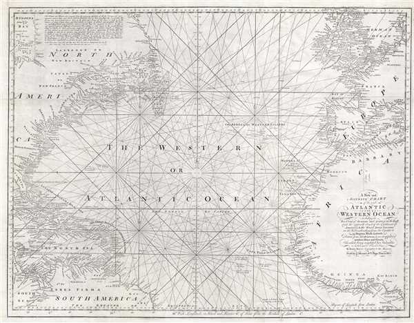
A New and Accurate Chart of the vast Atlantic or Western Ocean, including the Sea Coast of Europe and Africa on the East, and the opposite Coast of the Continent of America, and the West India Islands on the West; extending form the Equator to 59 Degrees North Latitude.
1778 (undated) 24 x 31 in (60.96 x 78.74 cm) 1 : 12000000
1778 (undated) 24 x 31 in (60.96 x 78.74 cm) 1 : 12000000
Description
A rare 1778 nautical chart of the northern Atlantic Ocean by then English cartographer Emmanuel Bowen. The map covers from, roughly, the Arctic Circle to the Equator and from western Florida and Cuba to Sardinia and Denmark. Inland detail is minimal although coastal cities are noted thoroughly. Shallow regions, particular the Grand Banks off Newfoundland, are defined by a combination of stippling and numeric depth soundings. Rhumb lines appear throughout.
This map was introduced in the 1778 Mount and Page edition of The English Pilot, The Fourth Book. While inferior to the charts used by British naval officers, this map and its associated volume, were popular with merchant pilots, slavers, smugglers, and pirates active in the trans-Atlantic. Since this chart appeared just after the outbreak of the American Revolutionary War we can safely assume that Bowen recognized the opportunity afforded by the war for an affordable large format chart of the Atlantic. The extant of the chart, reach well into the coastlands of West Africa to the bight of Benin makes apparent its utility to those engaged in underhanded trades.
Bowen derived this map from his own sources but also heavily references earlier French maps, most specifically the 1738 map of the western ocean issued for the Conte du Maurepas and the 1751 map of North America by J. G. B. D'Anville. It was drawn by Emmanuel Bowen and sold by Mount and Page of Tower Hill, London. There were only five subsequent issues of the Fourth Book following the 1778 edition in which this appeared. Not all subsequent editions contained this map and the book had smaller and smaller print runs as it declined in popularity throughout the latter part of the 18th century. Few examples of this map survive today and it rarely appears on the market.
CartographerS
Emanuel Bowen (1694 - May 8, 1767) had the high distinction to be named Royal Mapmaker to both to King George II of England and Louis XV of France. Bowen was born in Talley, Carmarthen, Wales, to a distinguished but not noble family. He apprenticed to Charles Price, Merchant Taylor, from 1709. He was admitted to the Merchant Taylors Livery Company on October 3, 1716, but had been active in London from about 1714. A early as 1726 he was noted as one of the leading London engravers. Bowen is highly regarded for producing some of the largest, most detailed, most accurate and most attractive maps of his era. He is known to have worked with most British cartographic figures of the period including Herman Moll and John Owen. Among his multiple apprentices, the most notable were Thomas Kitchin, Thomas Jeffreys, and John Lodge. Another apprentice, John Oakman (1748 - 1793) who had an affair with and eventually married, Bowen's daughter. Other Bowen apprentices include Thomas Buss, John Pryer, Samuel Lyne, his son Thomas Bowen, and William Fowler. Despite achieving peer respect, renown, and royal patronage, Bowen, like many cartographers, died in poverty. Upon Emanuel Bowen's death, his cartographic work was taken over by his son, Thomas Bowen (1733 - 1790) who also died in poverty. More by this mapmaker...
Mount and Page (fl. 1701 - 1760) was a London based firm of religious and maritime publishers that flourished in the 18th century. With the publication of the 1732 English Pilot, the Mount and Page name became well-known worldwide as an imprint of nautical charts. The firm was founded at Tower Hill, London, in 1701 by Richard Mount (1654 - 1722) and his apprentice Thomas Page (1780 - March 15, 1733). Mount had previously been in partnership with his father-in-law William Fisher (1631 - 1691) and inherited the business on the latter's death. Page completed his apprenticeship in 1716. Now fully partnered, Mount and Page subsequently acquired the map plates several defunct British nautical chart publishers, including Greenville Collins, Jeremiah Seller, Charles Price, and John and Samuel Thornton - thus nearly monopolizing the British nautical chart business. The firm consequently received several lucrative government contracts and thereby flourished throughout the 18th century, making the fortunes of both families. Successive generations of Mounts and Pages worked in the business, and the families intermarried. Its staple titles were The English Pilot and Navigatio Britannica by John Barrow. By the 1760s, Richard Mount's grandson John Mount (1725 - 1786) was able to retire to Berkshire where he built the stately mansion, Wasing Place. John's son William (1753 - 1815) was the last to work in the map business, and later generations went into politics. Learn More...
Source
Mount, J., and Page, T., The English Pilot. The Fourth Book, (Mount and Page: London) 1778.
The English Pilot, published from 1671 to 1794, was the brain child of John Seller (1630 – 1697). Seller, recognizing a lack of quality English-made nautical charts, began to compile and engrave charts for a new maritime atlas as early as 1669. That same year he announced the publication of the English Pilot. The work was intended to be published in geographically specific volumes such that only the necessary maps need accompany a voyage. The English Pilot, The First Book, covering English waters, was published in 1671. Despite his claims, most of the maps in the first book were not English productions, but rather worn out Dutch map plates purchased as scrap and then retooled with Seller's imprint. Nonetheless, the work proved popular among merchant seamen and earned him the title 'Hydrographer in Ordinary' as well as copyright protection for 30 years. Seller failed to fully realize his grand scheme but it was picked up in earnest by other cartographers, including William Fisher, John Thornton, John Wingfield, Richard Mount and Thomas Page. Subsequent volumes followed including The Second Book, covering the Mediterranean; The Third Book covering African and Arabian coasts; The Fourth Book comprising the first British atlas exclusively dedicated to the Americas; The Fifth Book, a volume of practical Navigation; and The Sixth Book focusing on East Asian waters. The English Pilot was issued in over 40 editions with a print run exceeding 100 years. It was also pirated by George Grierson and published in Dublin under his imprint. It is one of the most important British atlases ever published.
Condition
Very good. Minor verso reinforcement and repair along original fold lines. Else clean. Printed in two sections, joined by publisher.
References
New York Public Library, Map Division, b13868971. OCLC 40122713.