This item has been sold, but you can get on the Waitlist to be notified if another example becomes available.
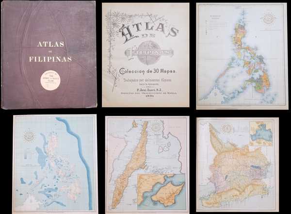
1900 Algué Atlas of the Philippine Islands (Philippines)
AtlasFilipinas-uscgs-1900$475.00

Title
Atlas de Filipinas Colección de 30 Mapas. / Special Publication No. 3 Atlas of the Philippine Islands.
1900 (dated) 14 x 12 in (35.56 x 30.48 cm)
1900 (dated) 14 x 12 in (35.56 x 30.48 cm)
Description
This is a 1900 José María Algué atlas of the Philippines. The atlas consists of twenty-four maps of the Philippines and one map of the Pacific. Each map depicts a different aspect of the archipelago. Some of the maps in the atlas include an ethnographic and an orographic map of the archipelago, a map locating the meteorological and seismographic stations throughout the archipelago, and numerous specific maps of the islands, or parts of the islands. Each map bears the seal of the Manila Observatory overlaid with the map's title. General information is included in the first few pages of the atlas, such as the number of islands, mineral and agricultural resources, and an index of geographic names within the archipelago, organized alphabetically. Perhaps the best description of the genesis of the atlas, and its contents, can be found in the introduction, penned by Henry Smith Pritchett, the director of the U.S. Coast and Geodetic Survey
Shortly after the Philippine commissioners reached Manila it was learned that a series of maps, covering the more important islands of the archipelago, was being prepared at the Jesuit Observatory under the supervision of the director, Rev. José Algue, S.J. An inspection of such of the maps as already had been completed satisfied the commission that they were superior to anything hitherto published. It was learned that the Jesuit Fathers planned to make the series quite complete, but that they had no definite ideas as to when the work would be completed or how the maps would be published eventually. The commission conceived the idea of securing their cooperation in the preparation of a comprehensive atlas of the archipelago, and with this end in view asked them to submit a tentative list of maps. The request was promptly complied with. After some discussion the series here published was decided upon, and an arrangement was entered into whereby it should be completed and become the property of the commission by August 15, 1899. […]While strictly accurate maps can never be prepared until the necessary surveys have been made, it is believed that this atlas fairly represents the present state of geographic knowledge of the Philippine Archipelago, and that it embodies a large amount of new information.This atlas was created under the direction of José María Algué, the director of the Manila Observatory, and published by the United States Coast and Geodetic Survey, under the direction of Henry Smith Pritchett, in 1900.
CartographerS
José María Algué (December 29, 1856 - May 27, 1930) was a Spanish Jesuit priest, scientist, and inventor, who specialized in meteorology. Father Algué was ordained as a priest in 1888. He studied meteorology, seismography, and astronomy at the University of Barcelona beginning in 1890. He eventually ended up in the Philippines, after internships at the Observatory de La Habana and elsewhere around the world. He worked for years as a collaborator and disciple of Federico Faura at the Meteorological Observatory of Manila, which Faura had founded. When Faura dies in 1897, Algué was named his successor, and served as the Director of the Manila Observatory, a post he kept even after the Spanish ceded control of the Philippines to the United States in 1898. Algué was very respected in his field, as evidenced by the fact that the U.S. Coast and Geodetic Survey published his Atlas de Filipinas in 1900, and that Algué was given the honor of representing both Spain and the United States before different institution, congresses and international exhibitions. More by this mapmaker...
The Office of the Coast Survey (1807 - present) founded in 1807 by President Thomas Jefferson and Secretary of Commerce Albert Gallatin, is the oldest scientific organization in the U.S. Federal Government. Jefferson created the "Survey of the Coast," as it was then called, in response to a need for accurate navigational charts of the new nation's coasts and harbors. The spirit of the Coast Survey was defined by its first two superintendents. The first superintendent of the Coast Survey was Swiss immigrant and West Point mathematics professor Ferdinand Hassler. Under the direction of Hassler, from 1816 to 1843, the ideological and scientific foundations for the Coast Survey were established. These included using the most advanced techniques and most sophisticated equipment as well as an unstinting attention to detail. Hassler devised a labor intensive triangulation system whereby the entire coast was divided into a series of enormous triangles. These were in turn subdivided into smaller triangulation units that were then individually surveyed. Employing this exacting technique on such a massive scale had never before been attempted. Consequently, Hassler and the Coast Survey under him developed a reputation for uncompromising dedication to the principles of accuracy and excellence. Unfortunately, despite being a masterful surveyor, Hassler was abrasive and politically unpopular, twice losing congressional funding for the Coast Survey. Nonetheless, Hassler led the Coast Survey until his death in 1843, at which time Alexander Dallas Bache, a great-grandson of Benjamin Franklin, took the helm. Bache was fully dedicated to the principles established by Hassler, but proved more politically astute and successfully lobbied Congress to liberally fund the endeavor. Under the leadership of A. D. Bache, the Coast Survey completed its most important work. Moreover, during his long tenure with the Coast Survey, from 1843 to 1865, Bache was a steadfast advocate of American science and navigation and in fact founded the American Academy of Sciences. Bache was succeeded by Benjamin Pierce who ran the Survey from 1867 to 1874. Pierce was in turn succeeded by Carlile Pollock Patterson who was Superintendent from 1874 to 1881. In 1878, under Patterson's superintendence, the U.S. Coast Survey was reorganized as the U.S. Coast and Geodetic Survey (C & GS) to accommodate topographic as well as nautical surveys. Today the Coast Survey is part of the National Oceanic and Atmospheric Administration or NOAA as the National Geodetic Survey. Learn More...
Henry Smith Pritchett (April 16, 1857 - August 28, 1939) was an American astronomer and educator. Born in Fayette, Missouri, Pritchett attended Pritchett College in Glasgow, Missouri and graduated with a B.A. in 1875. He then spent two years at the U.S. Naval Observatory under the tutelage of Asaph Hall, after which he became an assistant astronomer. He returned to Glasgow in 1880 for a job at the Morrison Observatory, where his father was the director. In 1882, Pritchett served as an astronomer on the Transit of Venus Expedition to New Zealand, and was appointed as a professor of mathematics and astronomy at Washington University in St. Louis upon his return in 1883. While at Washington University, Pritchett also served as the director of the observatory. Pritchett studied in Germany in the early 1890s and earned a PhD from the University of Munich in 1894. From December 1, 1897 until November 30, 1900, Pritchett was the Superintendent of the U.S. Coast and Geodetic Survey, and then was president of the Massachusetts Institute of Technology (MIT) from 1900 until 1906. After leaving MIT, Pritchett served as the president of the Carnegie Foundation for the Advancement of Teaching from 1906 until he retired in 1930. Learn More...
Condition
Good. Incomplete. Missing Map No. 2, No. 9, No. 26, No. 27, No. 29. Loose binding. Several maps are not bound into the atlas. Nearly all pages have some condition issue, usually small tears.
References
OCLC 65555133.