
This item below is out of stock, but another example (left) is available. To view the available item, click "Details."
Details
1842 Greenleaf Map of Australia and New Zealand
1842 (undated) $350.00
1849 Greenleaf Map of Australia and New Zealand
Australia-greenleaf-1849$175.00

Title
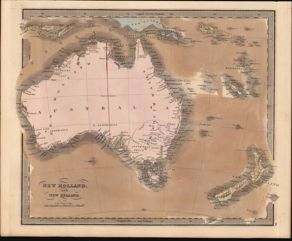
New Holland, And New Zealand.
1849 (undated) 11.5 x 14 in (29.21 x 35.56 cm) 1 : 19800000
1849 (undated) 11.5 x 14 in (29.21 x 35.56 cm) 1 : 19800000
Description
This is Jeremiah Greenleaf's 1849 map of Australia and New Zealand. This map features numerous minor updates over earlier editions reflecting the rapid exploration of the Australian interior between 1835 and 1849.
In 1644, the Dutch navigator Abel Tasman named the western half of the continent New Holland, leaving the eastern half unexplored but within the historic dominion of Spain. The decision was tactful, as it seized nominal control of Western Australia from Portugal, while not offending Spain, which then had suzerainty over Holland. In 1770, Captain James Cook mapped and claimed the unexplored eastern part of Australia for Great Britain.
Eighteen years later, in 1788, the British established the penal colony of New South Wales under Captain Arthur Phillip. Phillip's charter specifically set the colony's western border along the old Tordesillas anti-Meridian, 135°E. This, it has been noted, was to avoid conflict with Holland, which at the time, England was actively recruiting into the 1788 Triple Alliance as a buffer against the French. First Fleet officer Watkin Tench (1758 - 1833) subsequently commented in A Narrative of the Expedition to Botany Bay, 'By this partition, it may be fairly presumed, that every source of future litigation between the Dutch and us, will be forever cut off, as the discoveries of English navigators only are comprised in this territory.'
A Closer Look
The map follows the 1835 David H. Burr map of the same region - but with significant updates. Although coverage is focused on Australia, it extends to include New Zealand, the Solomon Islands, New Caledonia, and southern New Zealand. A red line through the center of Australia at 135° East Longitude separates New Holland from New South Wales (see below). Port Phillip, Melbourne, and Hobart Town are noted, along with a host of settlements spreading outward from Sydney. In Western Australia, we see Freemantle and the Swan River Colony.The Division of Australia
The division of Australia on the 135th East Meridian dates to 1786 when Captain Arthur Phillip received two commissions as governor of New South Wales. The line references the 1494 Treaty of Tordesillas, a Papal Bull that divided the world between Portugal and Spain. The Bull established a Meridian at 360 leagues west of the Cape Verde Islands - a point considered to be roughly the center of the Atlantic. This gave Portugal control over Brazil and routes around Africa, and Spain control over most of the Americas. The Tordesillas Treaty, however, assumed a flat Earth (scholars knew this was not so, but the church…). Magellan's circumnavigation (1519 - 1522) led to the establishment of an anti-Meridian in the Pacific. While there was some dispute between Spain and Portugal where the anti-Meridian ran, it was eventually settled at 135° East Longitude.In 1644, the Dutch navigator Abel Tasman named the western half of the continent New Holland, leaving the eastern half unexplored but within the historic dominion of Spain. The decision was tactful, as it seized nominal control of Western Australia from Portugal, while not offending Spain, which then had suzerainty over Holland. In 1770, Captain James Cook mapped and claimed the unexplored eastern part of Australia for Great Britain.
Eighteen years later, in 1788, the British established the penal colony of New South Wales under Captain Arthur Phillip. Phillip's charter specifically set the colony's western border along the old Tordesillas anti-Meridian, 135°E. This, it has been noted, was to avoid conflict with Holland, which at the time, England was actively recruiting into the 1788 Triple Alliance as a buffer against the French. First Fleet officer Watkin Tench (1758 - 1833) subsequently commented in A Narrative of the Expedition to Botany Bay, 'By this partition, it may be fairly presumed, that every source of future litigation between the Dutch and us, will be forever cut off, as the discoveries of English navigators only are comprised in this territory.'
Publication History and Census
This map is the later Greenleaf issue of the David Hugh Burr / Illman map of 1835. The Burr map plates fell into the hands of Jeremiah Greenleaf, who revised them for publication in his own Universal Atlas. The present example is from the 1849 edition of the atlas, the last and final, which was extensively revised over the 1848. We note an example in the David Rumsey collection, which has been populated digitally throughout OCLC, making a comprehensive survey of existing physical examples nearly impossible. Nonetheless, the 1849 edition of the atlas is rare, which Rumsey correctly notes is not in Karpinski. We do note an example, however, in Phillips.CartographerS
Jeremiah Greenleaf (1791 - 1864) is a little known but highly admired American cartographer of the early 19th century. He published from roughly 1830 to 1850. His most important work is A New Universal Atlas; Comprising of all the Principal Empires, Kingdoms, and States Throughout the World and Forming a distinct Atlas of the United States, published in several editions in the 1840s. Many of his maps are reformatted versions of his contemporary David Burr's much admired cartographic works. Greenleaf's maps are extremely rare and admired for their stunningly vivid pastel color washes. More by this mapmaker...
David Hugh Burr (August 18, 1803 - December 25, 1875) of one of the first and most important truly American cartographers and map publishers. Burr was born in Bridgeport Connecticut in August of 1803. In 1822 Burr moved to Kingsboro, New York to study law. A year and a half later he was admitted to the New York Bar association. Burr must have questioned his choice of careers because shortly after being admitted to the Bar, he joined the New York State Militia. Though largely untrained in the art of surveying, Burr was assigned to work under Surveyor General of New York, Simeon De Witt, to survey several New York Roadways. Seeing a window of opportunity, Burr was able to negotiate with the governor of New York at the time, De Witt Clinton, to obtain copies of other New York survey work in order to compile a map and Atlas of the state of New York. Recognizing the need for quality survey work of its territory, the government of New York heartily endorsed and financed Burr's efforts. The resulting 1829 Atlas of the State of New York was the second atlas of an individual U.S. state and one of the most important state atlases ever produced. Burr went on to issue other maps both of New York and of the United States in general. In cooperation with publishing firm of Illman & Pillbrow, he produced an important New Universal Atlas and, with J.H. Colton, several very important maps of New York City. In recognition of this work, Burr was appointed both "Topographer to the Post office" and "Geographer to the House of Representatives of the United States". Later, in 1855, Burr was assigned to the newly created position of Surveyor General to the State of Utah. Burr retired from the position and from cartographic work in general in 1857 when light of some of his financial misdeeds and frauds came to light. He was accused of submitting false expense reports and underpaying employees, among other indiscretions. Learn More...
Source
Greenleaf, J., New Universal Atlas, (Brattleboro, Vermont: Greenleaf) 1849.
Condition
Very good.
References
Rumsey 15176.030.