1865 Stokes Chart or Map of Eastern Australia: Barriga Point to Jervis Bay
AustraliaBarrigaJervis-stokes-1865$1,000.00

Title
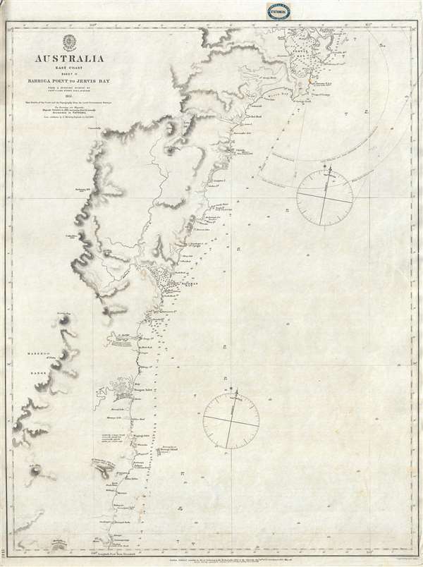
Australia East Coast Sheet II Barriga Point to Jervis Bay.
1865 (dated) 26 x 19.5 in (66.04 x 49.53 cm) 1 : 275000
1865 (dated) 26 x 19.5 in (66.04 x 49.53 cm) 1 : 275000
Description
This is an extremely rare 1865 map of eastern Australia covering from Jervis Bay to Barriga Point, including Ulladulla Harbor (then under construction) and Bateman Bay. It extends south as far as Mount Townsend. There are copious annotations regarding breakers, fords, tides, and other information useful to the mariner. This is one of the earliest large scale Nautical charts provide scientifically surveyed hydrographic detail for a significant portion of the Australian coast. It is the result of marine surveys completed by Commander John Lort Stokes and the HMS Acheron.
This map was printed by John Walker for the British Admiralty Hydrographic Office as chart number 2142. The original seller for this chart appears to have been J. D. Potter, of King Street, Tower Hill, London. It subsequently found its way to Melbourne, Australia, where it was sold by Blundell and Ford, Agents for the sale of Admiralty Charts. The chart was originally published in 1852. Updated states were issued in 1860 and, as here, 1865. All examples of this chart in all editions are extremely rare. We have identified two other examples of this chart, in different states, housed in the National Library of Australia and the State Library of Victoria. An example of the present 1865 state is housed at the Beinecke Library, Yale University. We are aware of no additional examples of the 1865 state.
This map was printed by John Walker for the British Admiralty Hydrographic Office as chart number 2142. The original seller for this chart appears to have been J. D. Potter, of King Street, Tower Hill, London. It subsequently found its way to Melbourne, Australia, where it was sold by Blundell and Ford, Agents for the sale of Admiralty Charts. The chart was originally published in 1852. Updated states were issued in 1860 and, as here, 1865. All examples of this chart in all editions are extremely rare. We have identified two other examples of this chart, in different states, housed in the National Library of Australia and the State Library of Victoria. An example of the present 1865 state is housed at the Beinecke Library, Yale University. We are aware of no additional examples of the 1865 state.
CartographerS
John Lort Stokes (August 1, 1811 – June 11, 1885) was a British Royal Navy officer, explorer, and hydrographer. Stokes grew up in Scotchwell near Haverfordwest, Pembrokeshire. He joined the Royal Navy on September 20, 1824. Stokes is famous as the commander of the HMS Beagle. He was assigned to the Beagle in 1824, acquiring the rank of midshipman in 1825, mate and surveyor in 1831, lieutenant in 1837, and commander in 1841. He remained with the HMS Beaglefor a total of 18 years, including during this historic 1833-1836 voyage of naturalist Charles Darwin, with whom he shared a cabin. Following the Darwin voyages in South America, the HMS Beagle was reassigned to Australia, where it carried out survey of the Australia coast. It was during this period that Stokes succeeded John Wickham as commander of the HMS Beagle. He was later given command of the HMS Acheron, with which he continued his survey of the Australian coastline. Stokes's delighted in exploration and his contribution to Australian cartography was significant, and includes the discovery of the Victory River, Port Darwin, the Flinders Rivers, and the Albert Rivers. He was speared by Aboriginals in 1839, but had full recovered by 1840. Stokes produced a several detailed charts of the Australian coast that, due to their accuracy, were still use nearly 100 years later. He retired from active duty in 1877, settling on his family estate in Scotchwell, Pembrokeshire, Wales. More by this mapmaker...
The British Admiralty Office (1795 - Present) or the United Kingdom Hydrographic Office refers to the Branch of the English government that is responsible for the command of the British Navy. In 1795 King George III created the United Kingdom Hydrographic Office, known in short as the U.K.H.O., to provide top notch nautical charts to the vast Royal Navy. Prior the founding of the Admiralty the surveying and creation of nautical charts was primarily a commercial venture wherein the cartographer himself, more of than not, actually financed the printing of his own material. The great navigator Cook himself is known to have scrambled for funds to publish his own seminal charts - the most important and advanced of the period. The system of privately funded nautical mapping and publishing left vast portions of the world uncharted and many excellent charts unpublished. King George III, responding significant loss in trade revenue related to shipwrecks and delay due to poor charts, recognized the need for an institutionalized government sponsored cartographic agency - the Admiralty. The first head of the Admiralty, a position known as Hydrographer, was the important cartographer Alexander Dalrymple. Dalrymple started by organizing and cataloging obtainable charts before initiating the laborious process of updating them and filling in the blanks. The first official Admiralty Chart appeared in 1800 and detailed Quiberon Bay in Brittany. By 1808 the position of Hydrographer fell to Captain Thomas Hurd. Hurd advocated the sale of Admiralty charts to the general public and, by the time he retired in 1829, had issued and published some 736 charts. Stewardship of the organization then passed to Rear Admiral Sir Francis Beaufort. It was under Beaufort's administration that the Admiralty truly developed as a "chart making" as opposed to a "chart cataloging" institution. Beaufort held his post from 1829 to 1854. In his 25 years at the Admiralty Beaufort created nearly 1500 new charts and sponsored countless surveying and scientific expeditions - including the 1831 to 1836 voyage of the H.M.S. Beagle. By 1855 the Admiralty's chart catalog listed some 1,981 charts. Learn More...
John Walker (1787 - April 19, 1873) was a British map seller, engraver, lithographer, hydrographer, geographer, draughtsman, and publisher active in London during the 19th century. Walker published both nautical charts and geographical maps. His nautical work is particularly distinguished as he was an official hydrographer for the British East India Company, a position, incidentally, also held by his father of the same name. Walker's maps, mostly published after 1827, were primarily produced with his brothers Charles Walker and Alexander Walker under the imprint J. and C. Walker. Among their joint projects are more than 200 maps for the influential Society for the Diffusion of Useful Knowledge Atlas (SDUK). In addition they published numerous charts for James Horsburgh and the British Admiralty Hydrographic Office, including Belcher's important map of Hong Kong and Carless' exploratory map of Karachi. The J. and C. Walker firm continued to publish after both Walkers died in the 1870s. Learn More...
Condition
Very good. Minor repairs upper right margin. Separate issue. Seller's stamp, top margin. Some pen marks related to navigational use.
References
OCLC 662514779. Yale University, Beinecke Library, 15237608.