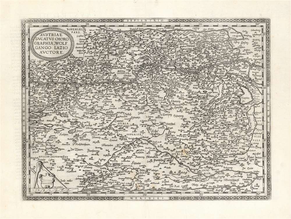
1581 Ortelius Map of the Duchy of Austria
Austria-ortelius-1570$650.00

Title
Austriae Ducatus Chorographia, Wolfgango Lazio Auctore.
1570 (undated) 13.25 x 18.25 in (33.655 x 46.355 cm) 1 : 11000000
1570 (undated) 13.25 x 18.25 in (33.655 x 46.355 cm) 1 : 11000000
Description
This is Abraham Ortelius' 1570 map of Austria. It depicts the lands lying between the Thaya River in the north and the Drava in the south. Between the two flows the Danube, from Waldkirchen am Wesen in the west to Bratislava in the east (here styled Bresburg). Vienna, of course, is prominently noted.
The Source
The map is based on the unacquirable 1561 Wolfgang Lazio's Typi chorographici Provinciae Austriae. Ortelius was noted for his assiduous search for the best, first-hand maps he could source, and he was scrupulous in crediting his sources. Several of his maps - this one, as well as those of Hungary and the Tirol - were drawn from the work of the Lazio.An Evocative Engraving
The woody terrain is depicted pictorially, and the map clearly evokes the complex river patterns spanning this part of the Danube Valley. Ortelius' choice of Germanic lettering stands in contrast to his typical use of Italic or Roman typefaces.Publication History and Census
This map was engraved in 1570 and was included in the first Latin editions of Ortelius' Theatrum. The plate remained in use until its replacement in favor of a broader-coverage map (also drawn from Lazio) in 1592. The present example conforms typographically to the 1581 French text edition, of which van den Broecke estimates there were 400 printed. It also conforms to the third state, with bold hachure in the rivers and lakes not evident in earlier states. Nine examples of that edition of the book are listed in OCLC. In various editions, the separate map is well represented in institutional collections.Cartographer
Abraham Ortelius (April 14, 1527 - June 28, 1598) also known as Ortels, was a cartographer, geographer, and cosmographer of Brabant, active in Antwerp. He was the creator of the first modern atlas, Theatrum Orbis Terrarum and is a seminal figure in the history of cartography. Along with Gerard Mercator and Gemma Frisius, he was a founder of the Netherlandish school of cartography. His connections with Spain - culminating in his 1575 appointment as Royal Cartographer to King Phillip II of Spain - gave him unmatched access to Spanish geographical knowledge during a crucial period of the Age of Discovery. Ortelius was born in 1527 in Antwerp. In 1547 he entered the Antwerp Guild of Saint Luke as an illuminator of maps. He began trading in books, prints, and maps, traveling regularly to the Frankfurt book and print fair, where in 1554 he met Mercator. He accompanied Mercator on journeys throughout France in 1560 and it was at this time, under Mercator's influence, that he appears to have chosen his career as a scientific geographer. His first published geographic work appeared in 1564, an eight-sheet cordiform world map. A handful of other maps preceded the 1570 publication of the first edition of the Theatrum Orbis Terrarum, which would prove to be his life work. Appearing with but 53 maps in its first edition, Ortelius' work expanded with new maps added regularly. By 1592, it had 134 maps. Many of Ortelius' maps remained the standard for nearly a century. He traveled extensively, but his genius was as a compiler, locating the best informed maps on which to base his own. His contacts throughout Europe and extending even (via the Portuguese) to the Far East were formidable. Moreover, many of his maps were based on his own scholarship, particularly his historical works. His theories of geography were particularly ahead of his time with respect to the notion of continental drift, the possibility of which he mused on as early as 1596, and which would be proven correct centuries later.
In a sense his greatest achievement was his successful navigation of the religious and political violence endemic to his city throughout his adult life: The Dutch Revolt, or Eighty Years' War (1568 - 1648), fully embroiled Antwerp. Although outwardly and officially recognized as Catholic (Arias Montanus vouched for Ortelius' Catholic orthodoxy prior to his appointment as Royal Geographer), Ortelius was able to separate himself from the religious furor which characterized the war in the low countries. Ortelius showed a glimpse of himself in a letter to a friend, regarding humanist Justus Lipsius: 'I do not know whether he is an adherent of the Pope or a Calvinist, but if he has ears to hear, he will neither be one nor the other, for sins are committed on both sides'. Ortelius' own explorations of Biblical history in his maps, and the Christogram contained in his own motto, suggest him to be a religious man, but his abjuration of political religious authorities mark him as an individualist. His tombstone at St Michael's Præmonstratensian Abbey in Antwerp bears the inscription, Quietis cultor sine lite, uxore, prole. ('served quietly, without accusation, wife, and offspring.') More by this mapmaker...
Source
Ortelius, A., Theatre de l'univers, contenant les cartes de tout le monde, (Antwerp) 1581.
Abraham Ortelius' magnum opus, Theatrum Orbis Terrarum, was the world's first regularly produced atlas, which 'set the standards for later atlases . . . It was the first undertaking of its kind to reduce the best available maps to an uniform format.' (Koeman) A modestly-sized work of fifty-three maps in its first edition of May 1570, it was an immediate success: there were three further editions that year, and the work remained in print for a total of 32 editions, the last of which was 1641, well after its author's 1598 death. Ortelius added to his atlas constantly, and by 1595 the Theatrum contained 147 maps. Ortelius is renowned generally as an editor, and indeed much of the Theatrum is compiled from a variety of sources: in such cases, Ortelius was scrupulous in naming his sources. But Ortelius was also a mapmaker in his own right: many of his maps are a distillation of various sources into his own work, and there were many maps - particularly in his atlas of Biblical and ancient history Parergon - which were entirely Ortelius' work. In his role as an editor, Ortelius followed in the footsteps of Munster, whose Cosmographia was, until Ortelius, the best window on the world for the curious European reader. In terms of the artistry of his maps, Ortelius oversaw the first great flourishing of copperplate engraving in the service of cartography to occur in Northern Europe. Ortelius' work provided the model for the atlases of Mercator, Hondius, Blaeu and all their progeny in the 17th century - many of whom were to produce faithful editions of Ortelius' maps in their own productions.
Condition
Very good. Three virtually invisible wormholes, two in margin. Else excellent with a bold, sharp strike.
References
Rumsey 10000.063. Koeman Ort 1B. Van der Krogt, P. C. J., Koeman's Atlantes Neerlandici, (3 Vols), #31:001B (with colophon #31:001C). van den Broecke, M., Ortelius Atlas Maps #105.3 (third state).