1853 Planning Map of the Back Bay, Boston
BackBayBoston-tappanbradford-1853$3,500.00


Title
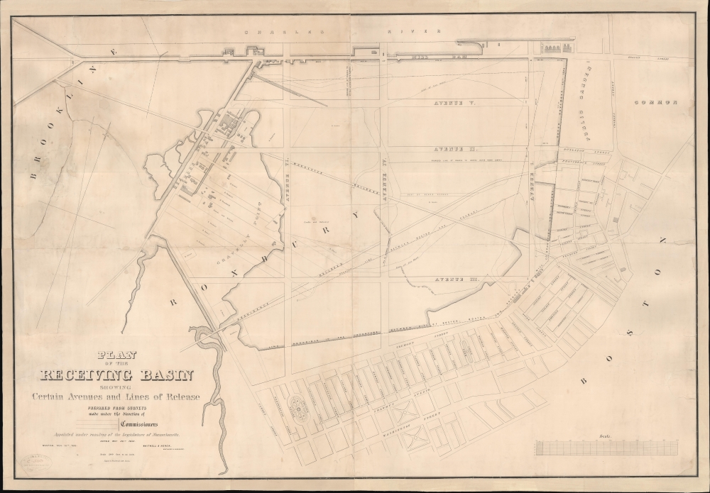
Plan of the Receiving Basin Showing Certain Avenues and lines of Release.
1853 (dated) 36 x 52 in (91.44 x 132.08 cm) 1 : 2400
1853 (dated) 36 x 52 in (91.44 x 132.08 cm) 1 : 2400
Description
One of the earliest published maps of the Back Bay, Boston, surveyed in 1852 in anticipation of the Back Bay Landfill. The map represents one of the earliest representations of the Back Bay, then a tidal swamp, overlaid with streets and avenues, thus part of Boston's grid. It shows the beginnings of the Back Bay Landfill efforts, as well as the beneficiaries of the project who would build enormous fortunes on the development.
The Mill Dam (Beacon Street) skirts the Charles River. Two railroad lines, the Worcester Railroad (I-90) and the Providence Railroad (Huntington Ave), crisscross at the center of the basin. Otherwise, when this survey was issued, much of these lands were under water - the natural tidal bay having been turned into a swampy sewage-filled morass by the 1814 construction of the Mill Dam. The waterline, extending into Brookline, is defined by hachure shading. The streets ghosted in, here named Avenues I-VI, never properly manifested but can be loosely broken down as
A Closer Look
The map covers from modern-day Kenmore Square (Brookline) to Boston Common and from the Charles River to roughly Washington Street. The focus is on what was then called the 'Receiving Basin,' a shallow tidal bay between Boston Common and Brookline. High and low waterlines are noted, as are several possible routes by which the water could be drained. Also noted are the property lots already acquired by wealthy real estate speculators such as David Sears and E. Francis.The Mill Dam (Beacon Street) skirts the Charles River. Two railroad lines, the Worcester Railroad (I-90) and the Providence Railroad (Huntington Ave), crisscross at the center of the basin. Otherwise, when this survey was issued, much of these lands were under water - the natural tidal bay having been turned into a swampy sewage-filled morass by the 1814 construction of the Mill Dam. The waterline, extending into Brookline, is defined by hachure shading. The streets ghosted in, here named Avenues I-VI, never properly manifested but can be loosely broken down as
- AVE. I - Arlington Street
- AVE. II - Boylston Street
- AVE. III - No modern equivalent
- AVE. IV - No modern equivalent
- AVE. V - Commonwealth Avenue
- AVE. VI - No modern
The Back Bay
The Back Bay emerged out of the dual needs of addressing overcrowding in Boston and the sanitary issues created by the construction of the Mill Dam and thus blockage waters flowing to and from the natural tidal bay that became the Mill Pond. The pond was gradually occupied by railroad and transport causeways, but significant planning of a major landfill did not take place until 1852. At that time, wealthy land speculators began buying up lots under the pond and using their political capital to push the project forward. Work began in earnest in 1857, but it took until 1882 for fill to reach modern-day Kenmore Square. The plan of Back Bay was compiled by civil engineer Arthur Gilman of the firm Gridley James Fox Bryant. It was influenced by Haussmann's renovation of Paris and, as such, featured wide, parallel, tree-lined avenues unlike anything seen in other Boston neighborhoods. The area immediately became popular with Boston's elite, with grand hotels, churches, parks, and elegant brownstone mansions constructed throughout.Publication History and Census
This map was surveyed in 1852 by Whitwell and Henck. It was engraved and printed in 1853 in Boston by Tappan and Bradford. The map bears the stamp of William H. Whitney, who was a Boston City Surveyor involved with the Back Bay project and the previous owner of this map. This map is rare. We note examples in the Boston Public Library and the State Library of Massachusetts. No history on the private market.Cartographer
Lodowick Harrington Bradford (November 10, 1820 - December 13, 1885) was a Boston based engraver lithographer active in the second half of the 19th century. Bradford was born in Boston, Massachusetts. He studied as a line engraver before transitioning to the then new art of lithography. He even invented his own photolithographic ambrotype process that created a durable photographic picture on lithographic stone. In 1849 he partnered with Ebenezer Tappen (1815 - 1854) to form the Boston firm of Tappan and Bradford. The partnership remained active until Tappan's untimely death in January, 1854. From 1854 to 1859 Bradford continued to operate the firm, but the imprint changed to 'L. H. Bradford and Company.' It is not clear who the 'and Company' was, possibly Tappan's heirs? From late 1859 until his 1870, he printed under 'L. H. Bradford.' His last known lithographs appeared in 1860, but he did continue copper and steel engraving until his death. Bradford was married to Martha Brown, from an old Gloucester Family. After his wedding in 1849, he divided his time between Gloucester and Boston. In Gloucester he made the acquaintance of the local painter Fitz Henry Lane (1804 - 1865) and worked with him to produce several views in the 1850s. He died on the road between Boston and Gloucester in 1885. More by this mapmaker...
Condition
Good. Restoration including fresh linen backing and stabilization of several large tears. Soiling. Some reinstatement of margin loss.
References
Boston Public Library, Leventhal Center, G3764.B6:2B2 1853 .P63.