This item has been sold, but you can get on the Waitlist to be notified if another example becomes available, or purchase a digital scan.
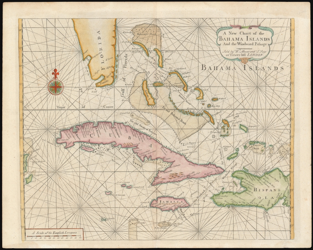
1737 Mount and Page Map of the Bahamas, Cuba, Florida
BahamaIslands-mountapage-1737$1,500.00

Title
A New Chart of the Bahama Islands and the Windward Passage.
1737 (undated) 17.25 x 21 in (43.815 x 53.34 cm) 1 : 2880000
1737 (undated) 17.25 x 21 in (43.815 x 53.34 cm) 1 : 2880000
Description
A rare 1737 map of the Bahamas, Florida, Cuba, and Jamaica issued by Mount and Page for the first edition of The English Pilot: The Fourth Book. The map, based upon a 1698 work by Samuel Thornton, illustrates the Bahamas during the 'Republic of Pirates' era (1698 - 1718), but has here been re-engraved by Mount and Page to capitalize on British interest in this region following increased Anglo-Franco-Spanish tensions surrounding the 1732 the founding of Georgia.
After Avery, other pirates and privateers, mostly English, began to call at Nassau, using their plunder to seize ever greater political power. Ideally suited to raid Spanish treasure flotillas, the Bahamas grew as a nexus of English privateering and piracy, leading combined French and Spanish fleets to sack Nassau in 1703 and again in 1706. Fearing further attacks, most of the law-abiding populace to fled to Jamaica or the mainland, leaving the islands firmly under pirate control. Among the pirates who visited or based themselves in the Bahamas were Benjamin Hornigold, Henry Jennings, Edward 'Blackbeard' Teach, 'Black' Sam Bellamy, Stede Bonnet, Charles Vane, 'Calico' Jack Rackham, Anne Bonny, Mary Read, and Woodes Rogers. By 1711, it was estimated that there were more than 1000 pirates based in Nassau.
Lacking a formal governance, the islands were administered via the pirate 'Codes of Conduct,' a set of strict rules generally more democratic and egalitarian than most contemporaneous governmental systems. For example, the pirate codes often called for fair distribution of spoils, limited voting rights, and, contrary to the reputation of pirates, punishment for rape and theft. The 'Pirate Republic' lasted until 1718 when one of their own, the English buccaneer Woodes Rogers (c. 1769 - 1732), turned official, accepting a Royal Governorship and turning the Bahamas into a Crown Colony.
A Closer Look
Centered on the Grand Bahama bank, the map covers from the Yucatan and island of Cozumel (Mexico), to Hispaniola, and from Florida to Jamaica. Within Florida, Tampa (Tompa) is noted and recognizable. There is a tenuous mapping of the Florida Keys, with Key West (Kegost) and Tortuga (Turtuga) noted.The 'Republic of Pirates' in the Bahamas
While resurrected in 1737 to reflect increased British interest in this area following the contentious 1732 founding of Georgia, we must stress that this map originally was drawn in 1706 - 1707 and reflects the cartography of that time. While the coverage might extend to cover many of the Greater Antilles, the real focus here is the English colony of the Bahamas. At this time, 1706 - 1718, the Bahamas were notorious 'Republic of Pirates.' Based in Nassau (New Providence), the Republic of Pirates can trace its origins to 1696, when the British privateer Henry Every (a.k.a. Avery, 1659 - c. 1715) took refuge there after ravaging Indian Ocean shipping. He unloaded 50 tons of elephant tusks and 100 barrels of gunpowder, among other treasures, bribing the English governor Nicholas Trott (1663 - 1740) to look the other way.After Avery, other pirates and privateers, mostly English, began to call at Nassau, using their plunder to seize ever greater political power. Ideally suited to raid Spanish treasure flotillas, the Bahamas grew as a nexus of English privateering and piracy, leading combined French and Spanish fleets to sack Nassau in 1703 and again in 1706. Fearing further attacks, most of the law-abiding populace to fled to Jamaica or the mainland, leaving the islands firmly under pirate control. Among the pirates who visited or based themselves in the Bahamas were Benjamin Hornigold, Henry Jennings, Edward 'Blackbeard' Teach, 'Black' Sam Bellamy, Stede Bonnet, Charles Vane, 'Calico' Jack Rackham, Anne Bonny, Mary Read, and Woodes Rogers. By 1711, it was estimated that there were more than 1000 pirates based in Nassau.
Lacking a formal governance, the islands were administered via the pirate 'Codes of Conduct,' a set of strict rules generally more democratic and egalitarian than most contemporaneous governmental systems. For example, the pirate codes often called for fair distribution of spoils, limited voting rights, and, contrary to the reputation of pirates, punishment for rape and theft. The 'Pirate Republic' lasted until 1718 when one of their own, the English buccaneer Woodes Rogers (c. 1769 - 1732), turned official, accepting a Royal Governorship and turning the Bahamas into a Crown Colony.
Publication History and Census
This map has an interesting and confused publication history. It was originally engraved by John Thornton sometime around 1698. Around 1707 the plate was revised to reflect Samuel Thornton, John Thornton's heir. The map was subsequently issued sporadically until 1737, when completely new plate by William Mount and Thomas Page, the present example, was engraved for their 1737 The English Pilot, the Fourth Book. The most significant difference between these two plates, aside from the' Thornton' vs 'Mount and Page' imprints, is that the Thornton had rhumb lines passing through the land. The rhumb lines were removed from the land by Mount and Page to make for easier reading. In 1749, the Irish pirate publisher George Grierson resurrected the map, with minor modifications to the imprint. A close comparison suggests that the Grierson map is actually a modified issue from the old Thornton plate, with all of its flaws, which Grierson must have somehow acquired. The 1737, Mount and Page issue, as here, enjoyed only a short publication run, being quickly superseded by other more detailed and general maps in later editions of The English Pilot. Very rare to the market.CartographerS
John Thornton (October 8, 1641 - January 23, 1708) was a British chartmaker, sea captain, publisher and engraver active in London during the late 18th and early 19th centuries. Thornton apprenticed to John Burston where mastered the art of manuscript maritime cartography as practiced by the Thames School. By the 1660s Thornton, working with John Seller and William Fisher, began publishing printed nautical charts and was the only Thames School cartographers to successfully transition to print. Thornton published numerous maps both independently and with some of the most prominent British publishers of his day, including the aforementioned as well as Herman Moll, Robert Morden, James Clark, Robert Greene, and Philip Lea. From around 1665 Thornton took over from Seller the production of the English Pilot. Upon his death in 1708 Thornton willed his charts, copper plates, instruments, and 'all things belonging to my calling' to his son, Samuel Thornton, who continued to republished his father's work, with few updates, until about 1715. More by this mapmaker...
Mount and Page (fl. 1701 - 1760) was a London based firm of religious and maritime publishers that flourished in the 18th century. With the publication of the 1732 English Pilot, the Mount and Page name became well-known worldwide as an imprint of nautical charts. The firm was founded at Tower Hill, London, in 1701 by Richard Mount (1654 - 1722) and his apprentice Thomas Page (1780 - March 15, 1733). Mount had previously been in partnership with his father-in-law William Fisher (1631 - 1691) and inherited the business on the latter's death. Page completed his apprenticeship in 1716. Now fully partnered, Mount and Page subsequently acquired the map plates several defunct British nautical chart publishers, including Greenville Collins, Jeremiah Seller, Charles Price, and John and Samuel Thornton - thus nearly monopolizing the British nautical chart business. The firm consequently received several lucrative government contracts and thereby flourished throughout the 18th century, making the fortunes of both families. Successive generations of Mounts and Pages worked in the business, and the families intermarried. Its staple titles were The English Pilot and Navigatio Britannica by John Barrow. By the 1760s, Richard Mount's grandson John Mount (1725 - 1786) was able to retire to Berkshire where he built the stately mansion, Wasing Place. John's son William (1753 - 1815) was the last to work in the map business, and later generations went into politics. Learn More...
Source
Mount, W. and page, T., The English Pilot: The Fourth Book, (London: Mount and Page) 1737.
Condition
Very good. Wide margin. Even toning.
References
OCLC 832432094. New York Public Library, Map Div. 02-295. Phillips, P.L. (Atlases) 1157-22.