1721 Covens and Mortier Map of the Bay of All Saints, Brazil
BahiaTodosSanctos-covensmortier-1721$1,400.00

Title
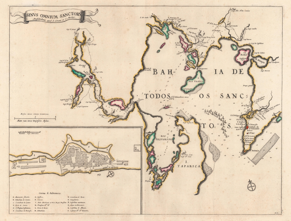
Sinus Omnium Sanctorum.
1721 (undated) 15.5 x 20 in (39.37 x 50.8 cm) 1 : 200000
1721 (undated) 15.5 x 20 in (39.37 x 50.8 cm) 1 : 200000
Description
This is a c. 1721 Covens and Mortier map of All Saints Bay or the Baía de Todo os Santos, and the city of Salvador, the 18th-century economic and political center of Portuguese Brazil.
A Closer Look
The map is derived from the Joan Blaeu map of 1662, with few changes. Coverage embraces the important Baía de Todos os Santos. Salvador, then the capital of Portuguese Brazil appears near the bay's mouth. Forts are identified in the vicinity of Salvador and multiple locations are named around the bay, likely villages with churches. Many of the bay's islands are labeled, including Itaoarica, the Ilha dos Frades, and the Ilha de Maré. An inset map of Salvador occupies the lower left with 18 locations alphabetically identified.Salvador
Originally called São Salvador da Bahia de Todos os Santos, Salvador is today the capital of the modern Brazilian state of Bahia. It was established by the Portuguese in 1549 as the first colonial capital of Brazil. To its strategic location on the northeastern coast, and shelterd deep water port, it became a hub for the export of sugar and import of slaves. As this map was being printed, Salvador was enjoying period of prolonged growth and prosperity and it is during this period that much of his renowned baroque architecture, today a UNESCO World Heritage Site, was constructed.Publication History and Census
This map was published by Covens and Mortier c. 1721. We note two cataloged examples of this edition: Bibliothèque nationale de France and Harvard University.Cartographer
Covens and Mortier (1721 - c. 1862) was an Amsterdam publishing firm, the successor to the extensive publishing empire built by Pierre Mortier (1661 - 1711). Covens and Mortier maps are often criticized as derivative - but this is not fully the case. Pierre Mortier lived in Paris from 1681 to 1685. There he established close relationships the the greatest French cartographers of the era, including De L'Isle and D'Anville. His business model was based upon leveraging Dutch printing technology and sophistication to co-publish state of the art French cartography. Upon Mortier's death in 1711 his firm was taken over by his son, Cornelius Mortier (1699 - 1783). Cornelius married the sister of Johannes Covens (1697 - 1774) in 1721 and, partnering with his brother in law, established the Covens and Mortier firm. Under the Covens and Mortier imprint, Cornelius and Johannes continued in Pierre's model of publishing the most up-to-date French works with permission. They quickly became one of the largest and most prolific Dutch publishing concerns of the 18th century. The firm and its successors published thousands of maps over a 120 year period from 1721 to the mid-1800s. During their long lifespan the Covens and Mortier firm published as Covens and Mortier (1721 - 1778), J. Covens and Son (1778 - 94) and Mortier, Covens and Son (1794 - c. 1862). More by this mapmaker...
Condition
Very good. Old color. Light wear along original centerfold.
References
Bibliothèque nationale de France, département Cartes et plans, GE D-13987. Harvard Map Collection MAP-LC G5562.A4 1721 .C6. Van de Krogt 9855:2.2.