
1976 Bahrain Ministry of Works Geomorphological Wall Map

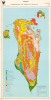
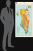
Bahrain Geomorphology and Superficial Materials.
First Comprehensive Geological Survey of Bahrain
$10,000.00
Choose a Collection:
This Item
Enquire
First Comprehensive Geological Survey of Bahrain
This is a colorful c. 1976 geological map of Bahrain, prepared by the country's Ministry of Works, Power, and Water in conjunction with a team of British scientists. It was the product of the seminally important first comprehensive geological Survey of Bahrain, compiled soon after independence.A Closer Look
The map covers the entirety of Bahrain, including the Island of Bahrain and several of the country's smaller islands, including Muharraq Island at top-right, home to Bahrain International Airport, and Sitra at right, which houses the country's main oil refineries and natural gas terminals. Hawar Island and several other outlying islands near Qatar are excluded. In the years since this map's production, land reclamation has expanded these islands (especially around the capital, al-Manāma, Muharraq, and Sitra) and also created entirely new ones. Settlements and roads are noted here, while a brilliant array of colors delineates the county's terrain and geology, from salt pans and coastal plains to areas of rock and bedrock in the country's relatively elevated interior. As with other highly detailed geological survey maps of the era, the grid surrounding the map here is not the traditional latitude-longitude system based on the Greenwich Meridian but a UTM (Universal Transverse Mercator) grid.The Bahrain Surface Materials Resources Survey
Bahrain was among the first territories in the Persian Gulf where oil was discovered, and oil exports were a dominant part of the economy when this map was produced. However, the country's leaders and planners understood the trouble of being so reliant on a single commodity and aimed to diversify the economy; though this effort has been widely hailed as a success, petroleum still accounts for most of Bahrain's exports and a significant share of GDP.The Bahrain Surface Materials Resources Survey was carried out at the request of the government of Bahrain between 1974 and 1976 by a team of British scientists, led by Denys Brunsden, John C. Doornkamp, and David K. C. Jones, of the University of London, University of Nottingham, and London School of Economics, respectively. The impetus for the Survey was concern about Bahrain's economic future, given declining oil reserves from known sites and the lack of detailed geological surveys of the entire kingdom. A detailed survey could also help plan engineering projects seen as critical to the country's future, such as dry docks capable of handling supertankers and desalination plants. The Survey also followed closely on Bahrain's achievement of independence in 1971, making it one of the most important scientific projects in the young country's history. Additionally, the Survey provided information that aided in the understanding of the less inhabited and underdeveloped southern portion of Bahrain Island.
The Survey team had their work cut out for them, as most of the lands of the kingdom had not been surveyed at a scale close to the 1:10,000 desired for the country's north. By cleverly combining existing maps and aerial photography with their own fieldwork, the team was able to complete preparations for the report by March 1976. The largest scale maps (1:10,000) were only printed for the Ministry of Works, Power, and Water, while the present 1:50,000 scale map was published with the group's monumental six-volume report Bahrain Surface Materials Resources Survey, only cataloged at the University of Oxford and University of Exeter (OCLC 1088523996, 166267217). The resulting work was one of the most detailed and celebrated geological studies undertaken in any of the world's arid regions and an essential resource for the government of Bahrain to use in its future economic and infrastructural planning.
Publication History and Census
This map was prepared by the members of the Bahrain Surface Materials Resources Survey between 1974 and 1976 and published in 1976 as part of the Survey's report Bahrain Surface Materials Resources Survey. Both the full report and its individual maps are rare, with the present map being independently cataloged among the holdings of some 15 institutions in the OCLC, eight of which are in the United States.Condition
Good. Closed edge tears professionally repaired on verso. Old cellophane tape in 3 of 4 corners.
References
OCLC 8113387, 903125549. Brunsden, D., Doornkamp, J., and Jones, D., 'The Bahrain Surface Materials Resources Survey and Its Application to Regional Planning,' The Geographical Journal Vol. 145 No. 1 (Mar) 1979, pp. 1-35.