1669 Hendrick Doncker Chart of Majorca, Minorca and Ibiza
Balearides-doncker-1669$2,500.00

Title
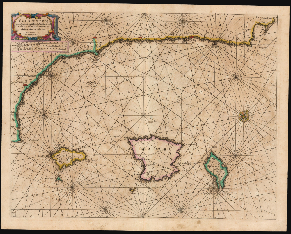
Valentien ende Catalonia tusschen C. de S. Martin ende C. de Creos als mede de eylanden van Majorca, Minorca ende Yvica. 'T Amsterdam: by Hendrick Doncker.
1669 (undated) 15.25 x 20 in (38.735 x 50.8 cm) 1 : 907000
1669 (undated) 15.25 x 20 in (38.735 x 50.8 cm) 1 : 907000
Description
This is Hendrick Doncker's rare c. 1669 chart of the Balearic Islands, portraying the islands of Majorca, Minorca, and Ibiza (Ibiça). The chart includes part of the Mediterranean coast of Spain, from C. St. Martin on the coast of Valencia to the Cap de Creus on the coast of Catalonia.
The chart includes depth soundings and anchorages on several points of each of the islands, and along the Spanish coast. At the upper right, the Gulf of Roses appears, with depth soundings and an anchorage.
A Closer Look
The chart is oriented to the northwest. (An apparent aesthetic choice, allowing the presentation of the coastline and primary islands more or less in line horizontally.) Majorca, Minorca, Ibiza, and Formentera are presented in outline, as are the smaller islands of Cabrera, Dragonera, and Monte Colibre - the Columbretes Islands. The coast of Valencia and Catalonia dominates the top part of the chart. All coastlines are delineated in pictorial coastal profiles; the sea is presented in the manner of a chart, with an attractive compass rose and rhumb lines.The chart includes depth soundings and anchorages on several points of each of the islands, and along the Spanish coast. At the upper right, the Gulf of Roses appears, with depth soundings and an anchorage.
The State of the Art
The Balearic Island maps of Blaeu and Jansson, and the Sanson of the middle part of the 17th century, had all derived largely from the 1612 mapping of Hessel Gerrritsz; the present chart represents a fascinating departure from that model, not less because the source of the new navigational information appearing here is not clear. The presence of the depth soundings and anchorages strongly suggests a firsthand source providing data to the Amsterdam chartmaker.Publication History and Census
This chart was engraved by Hendrick Doncker; the few cataloged examples have been variously dated, the earliest (unsupported) date being 1659. We do not see any examples included in hisZee-Atlas ofte Water-Werelt prior to 1669. We see only two auction records for the chart over the past 40 years, and there are no examples cataloged in OCLC.
Cartographer
Hendrick Doncker (1626 - 1699) (a.k.a. Henri Donker) was a Dutch bookseller and publisher of sea charts and nautical atlases active in Amsterdam during the middle part of the 17th century. He maintained a presence on Nieuwe Brugsteeg, Amsterdam. He married Elizabeth Abrahamsd Rensing in 1647. Doncker was somewhat unique to this period in that he did not copy the work of earlier cartographers, instead producing his own map. Moreover, Doncker's charts were widely admired for their constant revision and overall accuracy. In addition to producing his own charts, he also collaborated with Pieter Goos and Anthonie Jacobsz to producing the pilot guide De Zeespiegel. Following his 1699 death, Doncker's remaining stock and valuable map plates were acquired by Johannes van Keulen. He was survived by a daughter, Anna Doncker. More by this mapmaker...
Source
Doncker, H., Zee-Atlas ofte Water-Werelt, (Amsterdam: Doncker) 1669.
The classic Dutch atlas, whose publication ushered in the Dutch golden age of cartography. Willem Jansz Blaeu had been, since 1604, producing engraved maps for sale; these were separate issues (and all consequently extremely rare) until the publishing of Blaeu's Appendix in 1630 and 1631, which also included a number of maps purchased from the widow of Jodocus Hondius, (for example his famous iteration of John Smith's map of Virginia.) In 1634, he announced his intention to produce a new world atlas in two volumes, entitled Theatrum Orbis Terrarum, sive Atlas Novus (Théâtre du Monde ou Nouvel Atlas) (in an effort to invoke the successful work of the same title produced by Ortelius the previous century, while reinforcing the notion of it being a new work.) This work was published first in German in 1634, followed by Latin, Dutch and French editions in 1635. Blaeu's maps have always been noted for the quality of their paper, engraving and fine coloring, and this was the intent from the very start. The 1634 announcement of the upcoming work described it: 'All editions on very fine paper, completely renewed with newly engraved copperplates and new, comprehensive descriptions.' (van der Krogt, p,43) Many of the most beautiful and desirable maps available to the modern collector were printed and bound in Blaeu's atlases. Willem's son, Joan, would go on to add further volumes to the Atlas Novus, concurrently printing new editions of the first two volumes with additional maps, in effect making these new editions an entirely new book. Under Joan there would be nine Latin editions, twelve French, at least seven Dutch, and two German. This exceedingly successful work would be the mainstay of the Blaeu firm until 1661, at which point the work was supplanted by Joan Blaeu's masterwork Atlas Maior in 1662.
Condition
Very good. Light, even toning. Marginal mend well away from printed image. Else excellent with original outline color.
References
Not in OCLC.