
1791 John Moore Map of Nautical Chart of the Baltic Sea

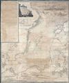
A New and Correct Chart of the Baltic from the Cattegat to Soderhamn and the entrance of the Gulf of Finland on a Mercator's Projection. Including the harbors of Riga, Carlshamn, Aus and Geffle, with Views of the principal Headlands taken from the best Swedish and Russian Surveys; and Improved by John Hamilton Moore Hydrographer and Chartseller to his Royal Highness the Duke of Clarence.
Reasserting Baltic trade after the Russo-Swedish War.
- Digital Map Information
- Suitable for large format printing
- DPI: 600
- File Size: 241.63 MB
- File Type: ZIP / TIFF
- ICC color profile embedded
- Delivered instantly via download link
Reasserting Baltic trade after the Russo-Swedish War.
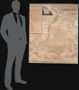
This is a 1791 wall-sized John Hamilton Moore nautical chart or map of the Baltic Sea. This chart was issued in the wake of the Russo-Swedish War (1788-1790), which ended the year prior, during a period where regional tensions still ran high. It nonetheless benefits from the cartographic advances of that war and represents a period where regional trade was being reestablished.A Closer Look
The map covers from the Gulf of Bothnia and the coast of Finland south to Pomerania, Prussia, and the Kattegat. In modern terms, this map covers the Baltic Sea in the vicinity of Sweden, Finland, Estonia, Latvia, Lithuania, Poland, Germany, and Denmark. It is a blueback in style, if not execution - there is no actual blue backing. There are several inset plans detailing the Harbor of Riga, the Harbor of Carlshamn, the city of Riga, Geffle Haven, and Ahus Haven / Lando Hamn. There are countless nautical soundings throughout, and a series of 26 shore profile views decorate the upper right and lower quadrants.The large decorative title cartouche, drawn and engraved by J. Stephenson, appears in the upper left quadrant and depicts a bucolic Scandinavian scene. One can only wonder if this J. Stephenson is the same or a relative of the John Stephenson, a coal trade captain, who is known to have provided Moore nautical information that was eventually compiled into some of his more popular charts of the North Sea and Thames Estuary.
Blueback Charts
Blueback nautical charts began appearing in London in the late 18th century. Bluebacks, as they came to be called, were privately published large-format nautical charts known for their distinctive blue paper backing. The backing, a commonly available blue manila paper traditionally used by publishers to wrap unbound pamphlets, was adopted as a practical way to reinforce the low-quality paper used by private chart publishers to cut costs. That being said, not all blueback charts are literally backed with blue paper, some are unbacked or backed with linen. Moreover, as blueback charts which were typically composed of multiple sheets, they were designed in a modular fashion, so that multiple charts could be joined to create truly massive custom maps suited for specific voyages. The earliest known blueback charts include a 1760 chart issued by Mount and Page, and a 1787 chart issued by Robert Sayer. The tradition took off in the early 19th century, when British publishers like John Hamilton Moore, Robert Blachford, James Imray, William Heather, John William Norie, Charles Wilson, David Steel, R. H. Laurie, and John Hobbs, among others, rose to dominate the chart trade. Bluebacks became so popular that the convention was embraced by chartmakers outside of England, including Americans Edmund March Blunt and George Eldridge, as well as Scandinavian, French, German, Russian, and Spanish chartmakers. Blueback charts remained popular until the late 19th century, when government-subsidized organizations like the British Admiralty Hydrographic Office and the United States Coast Survey began issuing superior charts on high-quality paper that did not require reinforcement.Publication History and Census
This chart was created and published by John Hamilton More in 1791. This chart is scarce. We have identified only two other examples, one in the collection of the Bibliothèque Nationale de France, the other in the Biblioteca Nacional de España.Cartographer
John Hamilton Moore (1738 - 1807) was a Scottish teacher of navigation, chartseller, and hydrographer active in London during the latter part of the 18th century. He is best known as a publisher of Blueback Nautical Charts and the founder of the firm that would one day become Imary and Son. Moore was born in Edinburgh and was educated in Ireland before joining the Royal Navy. After leaving the navy he set up a navigation academy in Brentford, Middlesex. Around 1772 he published the navigation textbook The New Practical Navigator and Daily Assistant. The work became the most popular such text of its day and ran into some 17 editions, firmly establishing Moore's credentials. Around 1781 Moore established himself at 127 Minories, near Tower Hill, London, where he taught navigation to a select audience as well as traded in navigational instrument and nautical charts. Moore began publishing his own charts. These were among the earliest blueback charts, called such for their distinctive blue paper backing. Moore took on draughtsman William Heather and John Noire, both future publishers of blueback nautical charts in their own right, to drawn and engraves his charts. Personally more was known to be boastful and somewhat controversial. He apparent once described himself as 'having a propensity for genius'. He was also accused of 'debauching a servant'. In the 1790s he started calling himself, 'Hydrographer and Chartmaker to his Royal Highness the Duke of Clarence'. It is unclear whether or not his claim was based on fact, but certainly Moore's many enemies in the chart publishing industry called him out on the matter, publishing a broadside declaring Moore a 'Pretender'. Either way, Moore dropped this claim by 1804. Moore was succeeded by a son, also John Hamilton Moore, and several daughters, one of whom married Robert Blachford, who became a prominent chart publisher in Moore's wake. Despite the seeming prosperity of his business, Moore seems to have died in relative poverty in Chingford, Essex. Nonetheless, his obituary in The Gentleman's Magazine, a sign in and of itself of Moore's social significance, offered him high praise, "he caused the best Charts to be published that had ever been done by any individual in this or any other nation." Further Details...
Condition
Good. Professionally restored and backed on clean linen. Some discolorations.
References
OCLC 762887904, 431781112.