1915 Rand Avery Railroad Map of Maine: Bangor and Aroostook Railroad
BangorAroostookRR-randavery-1915$400.00

Title
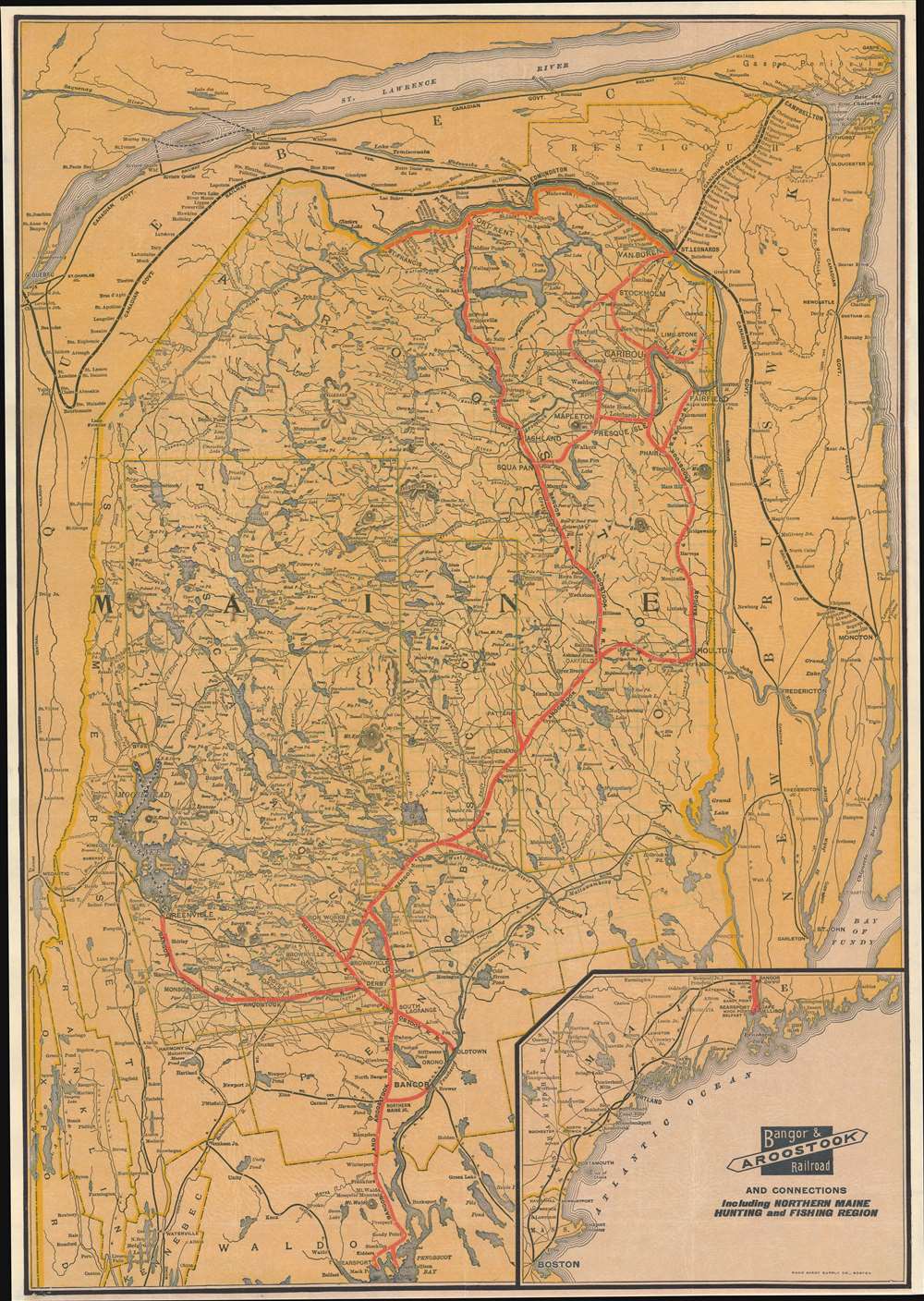
Bangor and Aroostook Railroad and Connections Including Northern Maine Hunting and Fishing Region.
1915 (undated) 25.25 x 17.75 in (64.135 x 45.085 cm) 1 : 610000
1915 (undated) 25.25 x 17.75 in (64.135 x 45.085 cm) 1 : 610000
Description
This is a c. 1915 Rand Avery Supply Company railroad map of Maine highlighting the Bangor and Aroostook Railroad. Covering from Belfast to Canada, a solid red line traces the Bangor and Aroostook Railroad's route. Cities, towns, and villages along the Bangor and Aroostook's route are labeled, including the then closed Katahdin Iron Works. Thin black lines follow the routes of the Maine Central Railroad, the Canadian Pacific Railroad, with a thicker black line emphasizing the Canadian Government Railway skirting Maine's northern and eastern borders. Lakes of varying size appear throughout, including Moosehead Lake near the left border. An inset map in the lower right presents the Maine Central Railroad and the Boston and Maine Railroad lines between Boston and Bangor.
Dating the Map
While undated, we are able to place the publication of this piece as c. 1915 because the bridge across the St. John's River connecting Van Buren, Maine, and St. Leonard, New Brunswick, did not open until 1915.The Bangor and Aroostook Railroad
The Bangor and Aroostook Railroad operated in Maine from 1891 until 2003. Incorporated in 1891, the Bangor and Aroostook Railroad emerged from a merger of the Bangor and Piscataquis Railroad and the Bangor and Katahdin Iron Works Railway. The railroad steadily expanded during the early 20th century, eventually connecting with the Canadian Government Railways at St. Leonard, New Brunswick, in 1915. In 1895, the Bangor and Aroostook began using heated box cars to haul potatoes, which they continued to do through the 1960s. Even in the post-World War II era, potatoes provided fifty percent of the railroad's income. However, it was not the advent of the interstate highway system that ended the railroad's relationship with potato farmers. During the winter of 1969 - 1970, due to systemic interchange issues caused by the Penn Central Transportation Company (another railroad), a large portion of the potato crop froze in the rail cars after the heaters ran out of fuel. This disaster caused several potato farms to go out of business and those that survived never again used rail transport. Other sources of income for the railroad included inbound chemicals and outbound paper from paper mills, transporting ammunition to Searsport during World War II, and taking coal and aircraft fuel to Loring Air Force Base during the Cold War. The railroad operated a morning and afternoon passenger train into the 1950s. The morning train, the Potatoland, made local stops from Bangor to Van Buren and St. Francis. The afternoon train, the Aroostook Flyer, only stopped at the most popular stations between Bangor and Van Buren. The Bangor and Aroostook was sold to Iron Road Railways in 1995, and after that company went bankrupt in 2002, Rail World acquired the line and incorporated them into the newly formed Montreal, Maine, and Atlantic Railway. The railway changed hands a few more times before being sold to the Canadian Pacific in 2019.Publication History and Census
This map was created and published by the Rand Avery Supply Company for the Bangor and Aroostook Railroad c. 1915. We note no other cataloged examples of this map.Cartographer
Rand, Avery, and Company (1851 – 1886) was a Boston based book and map printer active in the late 19th century. The company was founded in 1851 by George Curtis Rand (December 13, 1819 – December 30, 1878) and his brother-in-law Abraham Avery (November 15, 1824 - April 3, 1893). George C. Rand was a brother to William H. Rand of Rand, McNally, and Company of Chicago. George C. Rand was born in Woodstock, Vermont, to Baptist minister John Rand (1781 – 1855) and his wife. Rand began working in the printing industry from at least the 1840s, wherein he mostly produced religious tracts. He married Julia Avery in 1851 and brought his brother-in-law, Abraham Avery, into the business, renaming the firm Rand, Avery, and Company. Avery was born in Wibraham, Massachusetts and studied at Wesleyan University, which his father helped to found. Rand, Avery, and Company was based in Cornhill, Boston, and was, for a time, they were the largest printers in New England. Such works as Uncle Tom's Cabin were included in their catalog. Avery retired when Rand died in 1878, but the firm continued to publish under another generation of managers, including Rand's son, Avery L. Rand, until at least 1886. They also took on a fourth partner, Orrin F. Frye, and published as Rand, Avery, and Frye. After retiring Avery moved to Los Angeles where he died in 1893. It appears that this firm also published under the name the Rand Avery Supply Company. More by this mapmaker...
Condition
Very good.