This item has been sold, but you can get on the Waitlist to be notified if another example becomes available, or purchase a digital scan.
1853 U.S. Coast Survey Map or Chart of Bartaria Bay, Louisiana
BaratariaBay-uscs-1853$75.00

Title
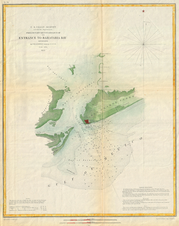
Preliminary Reconnaissance of the Entrance to Barataria Bay, Louisiana.
1853 (dated) 17 x 14 in (43.18 x 35.56 cm)
1853 (dated) 17 x 14 in (43.18 x 35.56 cm)
Description
This is an attractive 1853 U.S. Coast Survey chart or nautical map or Barataria Bay, Louisiana. Covers from Grand Isle and Bayou Rigaud eastward Past Fort Livingston and Forstall's Plantation. Extends northward past Mendicant Island to Independence Island and the Bay aux Chats. Includes notes on tides in the lower left hand quadrant and sailing instructions in the lower right. Barataria Bay, just south of New Orleans, is part of the series of swamps, bays and canals that make up the Mississippi River Delta. In the early 19th century this bay used as the base of the privateers led by Jean Lafitte. Today the bay is known for its rich resources, most notably shrimp and sulfur, muskrat furs, natural gas, and oil. The cartography for this map was accomplished by F. H Gerdes under the supervision of A.D. Bache, director of the U.S. Coast Survey. Engraved by Smith and Bradley for the 1853 edition of the Surveyor General's Report …
CartographerS
The Office of the Coast Survey (1807 - present) founded in 1807 by President Thomas Jefferson and Secretary of Commerce Albert Gallatin, is the oldest scientific organization in the U.S. Federal Government. Jefferson created the "Survey of the Coast," as it was then called, in response to a need for accurate navigational charts of the new nation's coasts and harbors. The spirit of the Coast Survey was defined by its first two superintendents. The first superintendent of the Coast Survey was Swiss immigrant and West Point mathematics professor Ferdinand Hassler. Under the direction of Hassler, from 1816 to 1843, the ideological and scientific foundations for the Coast Survey were established. These included using the most advanced techniques and most sophisticated equipment as well as an unstinting attention to detail. Hassler devised a labor intensive triangulation system whereby the entire coast was divided into a series of enormous triangles. These were in turn subdivided into smaller triangulation units that were then individually surveyed. Employing this exacting technique on such a massive scale had never before been attempted. Consequently, Hassler and the Coast Survey under him developed a reputation for uncompromising dedication to the principles of accuracy and excellence. Unfortunately, despite being a masterful surveyor, Hassler was abrasive and politically unpopular, twice losing congressional funding for the Coast Survey. Nonetheless, Hassler led the Coast Survey until his death in 1843, at which time Alexander Dallas Bache, a great-grandson of Benjamin Franklin, took the helm. Bache was fully dedicated to the principles established by Hassler, but proved more politically astute and successfully lobbied Congress to liberally fund the endeavor. Under the leadership of A. D. Bache, the Coast Survey completed its most important work. Moreover, during his long tenure with the Coast Survey, from 1843 to 1865, Bache was a steadfast advocate of American science and navigation and in fact founded the American Academy of Sciences. Bache was succeeded by Benjamin Pierce who ran the Survey from 1867 to 1874. Pierce was in turn succeeded by Carlile Pollock Patterson who was Superintendent from 1874 to 1881. In 1878, under Patterson's superintendence, the U.S. Coast Survey was reorganized as the U.S. Coast and Geodetic Survey (C & GS) to accommodate topographic as well as nautical surveys. Today the Coast Survey is part of the National Oceanic and Atmospheric Administration or NOAA as the National Geodetic Survey. More by this mapmaker...
Ferdinand H. Gerdes (September 15, 1809 - June 27, 1884) was one of the most active members of the U.S. Coast Survey team. His most important work includes several surveys of New York Harbor as well as detailed surveys of Florida, the Gulf Coast, and up the Mississippi River. Gerdes was born in Hanover, Germany (Prussia) and relocated to the United States sometime before 1836, when he joined he fledgling U.S. Coast Survey as an Sub-assistant under Hassler. From 1841 - 1844 he surveyed the New Jersey, Maryland, Delaware Bay Region. In 1844 he was assigned to the Gulf Coast, where he produced his most important and pioneering work. During the American Civil War, like most of the members of the Coast Survey, Gerdes was strongly pro-Union and worked diligently during the Civil War to provide Union commanders accurate surveying and cartographic materials. Gerdes is known to have commanded the ‘Sachem' and, during the Civil War, was heavily engaged with Union efforts to map and ultimately control, the Mississippi River. Following the war he produced detailed surveys of the Passes of the Mississippi. His health and age catching up on him, Gerdes retired to New York, where he completed additional surveys of long island as late as 1883, a year before his death. Learn More...
Source
Report of the Superintendant of the U.S. Coast Survey, (1853 edition).
Condition
Very good condition Minor toningon original folds. Blank on verso.