This item has been sold, but you can get on the Waitlist to be notified if another example becomes available, or purchase a digital scan.
1794 Edwards and Stockdale Map of Barbados
Barbadoes-stockdale-1794$200.00

Title
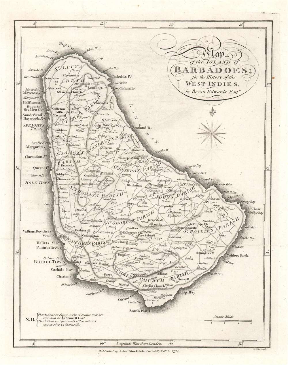
Map of the Island of Barbadoes.
1794 (dated) 10.25 x 8 in (26.035 x 20.32 cm) 1 : 176000
1794 (dated) 10.25 x 8 in (26.035 x 20.32 cm) 1 : 176000
Description
This is a 1794 Bryan Edwards and John Stockdale map of Barbados, which was then the most heavily fortified island in the Caribbean.
Fortifications
By 1728 the British constructed. twenty-three forts along the southwestern and western coasts. By 1780, more than forty forts stood on these coastlines. The northern and eastern coasts did not require fortifications due to rough seas, high cliffs, and a lack of harbors. Many of these forts are illustrated and labeled here, including Halfmoon Fort, Maycocks Fort, and Valliant Royalist Fort.Why So Many Forts?
The map's other notations provide the answer to why the British put forward so much effort to fortify the island. Dozens of plantations and sugar works covered the island by the mid-17th century and were driving a booming economy driven by slavery. By 1700, there were 50,000 enslaved Africans living in deplorable conditions. These conditions led to numerous slave rebellions, including Bussa's Rebellion in 1816, the largest slave rebellion in Barbados.Publication History and Census
This map was created by Bryan Edwards for publication in his book The History Civil and Commercial of the British Colonies of the West Indies and published by John Stockdale in 1794. Five examples are cataloged in OCLC and are part of the institutional collections at The British Library, the National Library of Scotland, the Bayerische Staatsbibliothek in Munich, the State Library of New South Wales, and the State Library of Victoria.CartographerS
Bryan Edwards (May 21, 1743 - July 15 or 16, 1800) was a British politician and colonial administrator active in the later part of the 18th century. Born in Westbury, England, Edwards lost his father at 13 years of age. His education was subsequently taken over by his uncle, Zachary Bayly, a wealthy merchant based in Jamaica. This would turn out to have a profound influence on Edwards. When Bayly died in the 1770s, Edwards inherited his uncle's substantial wealth and quickly rose to a position of prominence in the Colonial Assembly of Jamaica. Raised in the plantation culture of Jamaica, Edwards used his wealth and influence to advocate for the continuation of the slave trade. Despite being politically misguided, Edwards was regarded with respect by both his colleagues and opponents. During his long tenure in the West Indies, Edwards wrote a number of histories and administrative studies, many of which featured important cartographic works and offered an illuminating view of the British colonies in the region. He is also known to have returned to England on several occasions where he repeatedly attempted and failed to acquire a seat in Parliament. Eventually, he was elected to represent the Cornish borough of Grampond, though the election itself may have been corrupt. Edwards was also secretary of the Association of Promoting the Discovery of the Interior Parts of Africa. In this capacity, he wrote of the first known account of the travels of Mungo Park in Africa. More by this mapmaker...
John Stockdale (March 25, 1750 - June 21, 1814) was an English book and map publisher active in London in the late 18th and early 19th centuries. Stockdale, born in Caldbeck, England, was trained by his father in the family trade of blacksmithing. Blacksmithing must not have been his cup of tea, for as soon as he was able, he left this trade in favor of a number of minor service positions, working at various times as a porter and a valet. One such position put him in the service of the bookseller John Almon. Having learnt the book trade by observing Almon, Stockdale opened his own bookshop and began publishing various historic and scientific works. Fellow publishers, perhaps reacting to his social status at birth, wrote of him, "being a man of natural parts, he soon became conspicuous in business in spite of much eccentricity of conduct and great coarseness of manners." Never quite accepted in the trade, Stockdale's fellow London publishers derogatorily referred to him as "The Bookselling Blacksmith". Nonetheless, Stockdale had a number of important works to his name, including several geographies, most notably the 1794American Geography 1794 and, with John Cary, the 1805 New British Atlas. Learn More...
Source
Edwards, Bryan, The History Civil and Commercial of the British Colonies of the West Indies, 1800.
Condition
Very good. Exhibits light offsetting.
References
OCLC 822014665.