1814 Thomson Map of Barbados and St. Vincent, West Indies
BarbadoesStVincent-thomson-1814$350.00

Title
St. Vincent. / Barbadoes. / West India Islands.
1814 (dated) 21 x 25 in (53.34 x 63.5 cm) 1 : 85000
1814 (dated) 21 x 25 in (53.34 x 63.5 cm) 1 : 85000
Description
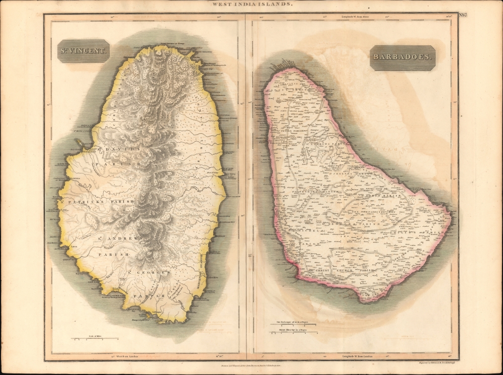
This is John Thomson's 1814 map of Barbados and St. Vincent, both part of the Lesser Antilles volcanic arc, West Indies. It illustrates the final days of slavery on both islands, and coincides with a period marked by internal strife, social upheaval, economic decline, and rebellion.
Barbados
From the 17th century, Barbados was one of the most prosperous British West Indian colonies with a large slave-driven sugar-growing economy. As evident on this map, there are hundreds of plantations and sugar mills - represented tiny windmills - scattered throughout, with landowners named. Nonetheless, when this map was issued, slavery was in decline in British colonies and with it, the plantation economy. In 1816, when this map was being printed, Barbados' enslaved rose up in the first of three rebellions in the British West Indies, and the largest slave uprising in the island's history. The rebellion largely surprised planters, who felt their slaves were content because they were allowed weekly dances, participated in social and economic activity, and were generally fed and looked after - notwithstanding the Barbados Slave Code, which denied slaves human rights and prescribed inhumane torture, mutilation, or death as a means of control. Unlike, neighboring St. Vincent, which is mountainous and densely jungled, Barbados offered wide flat terrain, which strongly favored British rather than guerilla tactics. The rebellion failed militarily, and most combatants were deported. It did, however, set the stage for progressive legislative reform culminating in the abolition of slavery on Barbados by 1834.St. Vincent
The map reveals St. Vincent during a period of economic decline. St. Vincent was first occupied by the French but was ceded to England after the Seven Years' War (1756 - 1763). Like the French before them, the British maintained only a tenuous control over the island, with powerful Carib tribes dominating the mountainous north and western slopes - as shown here. The First Carib War (1769 - 1773) ended in a stalemate. The Second Carib War began in 1795. With the support of French Revolutionary advisors and troops from Martinique, the Caribs pushed towards the British stronghold of Kingstown. They were ultimately repulsed when British reinforcements, led by General Ralph Abercromby, led a major expedition into Carib-held territory. More than 5,000 black Caribs were deported from Saint Vincent first to the island of Baliceaux, off Bequia, where half of them died in concentration camps, and then to the island of Roatán off the coast of present-day Honduras, where they later became known as the Garifuna people. In the following decades, the British attempted to establish a plantation economy, but the abolition of slavery in 1838 left most plantations abandoned and the economy in a long decline.Publication History and Census
This map was prepared and engraved in 1814 in Edinburgh by Kirkwood and Sons for inclusion in the 1817 first edition of John Thomson's New General Atlas.CartographerS
John Thomson (1777 - c. 1841) was a Scottish cartographer, publisher, and bookbinder active in Edinburgh during the early part of the 19th century. Thomson apprenticed under Edinburgh bookbinder Robert Alison. After his apprenticeship, he briefly went into business with Abraham Thomson. Later, the two parted ways, John Thomson segueing into maps and Abraham Thomson taking over the bookbinding portion of the business. Thomson is generally one of the leading publishers in the Edinburgh school of cartography, which flourished from roughly 1800 to 1830. Thomson and his contemporaries (Pinkerton and Cary) redefined European cartography by abandoning typical 18th-century decorative elements such as elaborate title cartouches and fantastic beasts in favor of detail and accuracy. Thomson's principle works include Thomson's New General Atlas, published from 1814 to 1821, the New Classical and Historical Atlas of 1829, and his 1830 Atlas of Scotland. The Atlas of Scotland, a work of groundbreaking detail and dedication, would eventually bankrupt the Thomson firm in 1830, at which time their plates were sequestered by the court. The firm partially recovered in the subsequent year, allowing Thomson to reclaim his printing plates in 1831, but filed again for bankruptcy in 1835, at which time most of his printing plates were sold to A. K. Johnston and Company. There is some suggestion that he continued to work as a bookbinder until 1841. Today, Thomson maps are becoming increasingly rare as they are highly admired for their impressive size, vivid hand coloration, and superb detail. More by this mapmaker...
Robert Kirkwood (December 8, 1774 – November 14, 1818) was a Scottish engraver active in Edinburgh during the late 18th and early 19th century. He is the scion of the important Scottish Kirkwood family, who produced a number of great engravers. His father was James Kirkwood, another well-known Edinburgh engraver, and probably the man who trained him in the engraver's art. Initially he patterned with his father and they published under the imprint of 'Kirkwood and Son,' but after about 1814 to his death, he published under his own name. Around 1803 Kirkwood invented and patented a modification to the standard printing press that increased printing speeds. He died at his home, 3 Arniston Place, in Edinburgh. He was survived by his son, also Robert Kirkwood (1798 – 1843) who continued the family engraving enterprise. Learn More...
Source
Thomson, J., A New General Atlas, (Edinburgh: Baldwin, Cradock, Joy) 1817.
Thomson's New General Atlas was first published in 1817 and continued to be published until about 1821. This is the first of Thomson's major cartographic works and the atlas for which is most celebrated. The New General Atlas follows in the Edinburgh School, which eschews excessive decoration in favor of a more minimalistic fact-based cartographic vision, as established by John Pinkerton, Laurie and Whittle, John Cary, and others in the previous decades. The maps are notable for their massive scale, heavy stock, elegant color work, and easy-to-read typefaces. Although the atlas stopped being published after 1821, Thomson continued to offer 'supplementary' maps that could be tipped into the atlas as late as 1830, when he declared bankruptcy. The maps in the Thomson Atlas were engraved by Thomas Clerk, William Dassauville, Nathaniel Rogers Hewitt, James Kirkwood, Robert Kirkwood, John Menzies, George Menzies, Edward Mitchell, John Moffatt, Samuel John Neele, Robert Scott, and James Wyld.
Condition
Very good. Original centerfold. Some offsetting.
References
Rumsey, 1007.073. Catalogue of maps of Hispanic America, v. 1, p. 245.