This item has been sold, but you can get on the Waitlist to be notified if another example becomes available, or purchase a digital scan.
1736 Herman Moll Map of Barbados
Barbados-moll-1736$112.50

Title
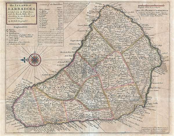
The Island of Barbadoes. Divided into its Parishes, with the Roads, Paths, etc. According to an Actual and Accurate Survey.
1736 (undated) 11.5 x 14.5 in (29.21 x 36.83 cm) 1 : 72864
1736 (undated) 11.5 x 14.5 in (29.21 x 36.83 cm) 1 : 72864
Description
This is a 1736 Herman Moll map of the island of Barbados. The map depicts the entire island with north oriented to the left. The island is divided into eleven parishes. Myriad locations are labeled all over the island, including the island's capital at Bridge Town. These locations are different than those illustrated on other maps because most do not appear to be towns, but individual plantations labeled by using the owner's last name. A handful of towns do exist, such as Bridge Town, Speights Town, and Oistins Town. Numerous locations, bays, and points are labeled all around the coast of the island. A few churches are noted with pictograms of a church, along with roads which snake all over the island, and a couple rivers. Topography is depicted in profile. A legend is located in the upper left corner below the title, along with a table listing the acreage of each parish and the total area of the island. Two comments, one discussing the size of the island, the other relating its history, also are included on the upper left. A beautiful compass rose sits below the title and legend.
This map was produced by Herman Moll and printed posthumously by Thomas Bowles for inclusion in Moll's Atlas Minor as plate no. 59.
This map was produced by Herman Moll and printed posthumously by Thomas Bowles for inclusion in Moll's Atlas Minor as plate no. 59.
CartographerS
Herman Moll (1654 - 1732) was an important 18th century map publisher and engraver based in London and Holland. Moll's origins are disputed with some suggesting he was born in the Netherlands and others Germany - the Moll name was common in both countries during this period. Most likely Moll was a German from Bremen, as his will, friends, and contemporaries suggest. What is known for certain is that he moved to London in 1678, possibly fleeing the Scanian War, where he worked as an engraver for Moses Pitt and other London map publishers. Around the turn of the century, Moll set up his own shop where he produced a large corpus of work known for its high quality and decorative flair. As a new émigré to England, Moll made himself more English than the English, and through his cartography proved a fierce advocate for his adopted nation. Most of Moll's early maps were issued as loose sheets that would be bound to order, however, he did publish several important atlases late in his career. Moll is said to have made the bold claim that without a doubt "California is an Island" and that he "had in [his] office mariners who have sailed round it." While California may not be an island (yet), it is true that moll had talent for attracting interesting friends and acquaintances. He frequented London's first stock exchange, Jonathan's Coffeehouse at Number 20 Exchange Alley, Cornhill. At the time Jonathan's was known as "a place of very considerable concourse for Merchants, sea faring Men and other traders" (Erleigh, The Viscount, The South Sea Bubble, Manchester: Peter Davies, Ltd., 1933, 21). Eventually this activity attracted the interest of stock brokers, who inspired by sailor's tales, sponsored the ill-fated South Sea Company, the world's first stock bubble. Moll's close circle, mostly from the Coffee House, included scientist Robert Hooke, the writers Daniel Defoe (Robinson Crusoe) and Jonathan Swift (Gulliver's Travels), the pirates William Dampier, William Hacke and Woodes Rogers, and the archeologist William Stukeley. Herman Moll's work was highly regarded for its decorative beauty and was pirated, most notably by the Irish publisher George Grierson, both in his lifetime and after his 1732 death at St. Clement Danes, London. More by this mapmaker...
The Bowles Family (fl. c. 1714 - 1832) were publishers and map sellers active in London from c. 1714 to c. 1832. The firm, under Thomas Bowles (fl. 1714 - 1763), John Bowles (1701 - 1779), Carrington Bowles (1724 - 1793), and as Bowles and Carver (fl. 1794 - 1832), produced a massive corpus of work that included numerous atlases, pocket maps, and wall maps. The Bowles publishing tradition was kept alive for four generations, starting with Thomas Bowles, a print engraver active in the late 17th century. His son, Thomas Bowles II, produced the firm's first maps at St. Paul's Churchyard, London. Thomas's brother, John Bowles (a.k.a. 'Old John Bowles' or 'Black Horse Bowles'), was also an active publisher established at no. 13 Cornhill. He is credited as one of the first publishers of William Hogarth's works. There, John's son, Carrington Bowles, was introduced to the trade. Carrington took over the Cornhill bookshop and eventually merged it with his uncle's shop in St. Paul's Churchyard. On Carrington's 1793 death, the business was passed to his son Henry Carrington Bowles (1763 - 1830), who partnered with his father's former apprentice Samuel Carver (1756 - 1841), renaming the firm 'Bowles and Carver'. Under this imprint, the firm continued to publish maps and atlases until 1832. Henry Carrington Bowles died in 1830, but Samuel Carver, himself in advanced years and poor health, kept it going for another 2 years before closing the business. Learn More...
Condition
Very good. Original press mark visible. Blank on verso.
References
OCLC 976970881.