
1863 Stanford Map of the Seven Basque Provinces, Spain and France


This item has been sold.
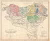
Carte des Sept Provinces Basques, montrant La Délimitation Actuelle de L'Euscara et sa division en dialectes, sous-dialects et variétés.
Definitive mapping of Basque dialects.
- Digital Map Information
- Suitable for large format printing
- File Size: 81.28 MB
- File Type: ZIP / TIFF
- ICC color profile embedded
- Delivered instantly via download link
Definitive mapping of Basque dialects.
This is an impressive large-scale 1863 linguistic map of the Basque country in Spain and France showing the dialects, varieties, and sub-varieties of the Basque language, Euskara. The map illustrates the philological of Louis Lucien Bonaparte, whose classifications of Euskara remains definitive.A Closer Look
Coverage embraces the Pays Basque in southwestern France, including Basse Pyrenées, and in northeastern Spain, including Gipuzkoa, Vizcaya, Pamplona, and Navarra. Color coding defines dialects, illustrating regional overlaps. This is one of two maps Bonaparte produced to illustrate his linguistic classifications.Euskara
Euskara, the Basque language, is an ancient language spoken in the Basque Country, a vast region spanning parts of northern Spain and southwestern France. Euskara is a language isolate, unlike its neighboring Romance languages, meaning it has no known linguistic relatives. It is one of the oldest languages in Europe, with roots that predate the arrival of Indo-European languages on the continent. Despite periods of suppression, particularly during the Franco dictatorship in Spain, Euskara has experienced a revival since the late 20th century, bolstered by regional autonomy and strong cultural movements. Today, efforts to promote and preserve Euskara include its inclusion in education, media, and public life, contributing to its resilience and cultural significance.Publication History and Census
This map was designed by Louis Lucien Bonaparte and engraved in London in Stanford's Geographical Establishment. While the map preparation occurred in 1862, the map was not published until 1863. Rare. We note perhaps 5 examples in OCLC, but numerous digitizations.Cartographer
Edward Stanford (May 27, 1827 - November 3, 1904) was one of the most prolific map publishing firms of the late 19th century. The company began as a partnership in 1848 between the 21 year old Edward Stanford and the established map dealer Trelawney Saunders. By 1853 the partnership had dissolved and Edward Stanford took full control of the business. A subsequent series of expansions and exciting new map issues finally led to the production of Stanford's masterwork, "Stanford's Library Map of London". This map is still available and remains somewhat accurate. At the time of publishing it was hailed by the Royal Geographical Society as "the most perfect map of London that has ever been issued". In 1882 Edward Stanford Sr. passed the firm on to his son, Edward Stanford Jr. who continued in his father's proud tradition. Today the Stanford firm still publishes maps and remains one of the most important and prolific cartographic publishers in the world. Further Details...
Condition
Very good.
References
Bilketa - Médiathèque de Bayonne, B641026201_MC397. OCLC 43422482.