
1973 GUGK Historical Wall Map of the Battle of Leningrad, World War II


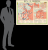
Битва за Ленинград / [Battle of Leningrad].
One the most brutal sieges in modern history.
One the most brutal sieges in modern history.
This is a dramatic 1973 wall map recounting the World War II Battle of Leningrad, issued by the Soviet Main Administration of Geodesy and Cartography (GUGK). Presented as a historical map, it is also persuasive, designed to glorify the Russian sacrifices during World War II (1939 - 1945), a major component of Soviet Brezhnev Era propaganda.A Closer Look
This large sheet consists of four maps. The largest at left is a general overview of the '900 Day Siege.' Red and blue arrows and lines depict the positions, fortifications, artillery batteries, and movements of Soviet and Axis (German primarily, but also Finnish and Spanish) troops. The map illustrates the tremendous complexity of the siege, involving not only the troops and civilians in Leningrad, but also naval and air forces and partisan units behind enemy lines. An inset at top-left covers in greater detail the operations of the Baltic Fleet in relation to the siege, including battles on and around Baltic islands, the wartime base of the Baltic Fleet at Kronstadt (Кронштaдт), and the defense of the Oranienbaum (Ораниенбаум) Bridgehead, an area west of Leningrad never captured by the Germans.The right half of the sheet contains three maps. Among the two smaller ones at top, the one at left covers the lifting of the blockade (Operation Iskra on January 18, 1943), while that on the right provides a general plan of Leningrad during the siege, noting defensive lines, the important contribution of marines of the Baltic Fleet to the city's defenses, and the areas subject to the most intense bombardment. The map at the bottom is an overview of the January 1944 Leningrad-Novgorod offensive, which decisively drove the Germans back.
The Siege of Leningrad
The Siege of Leningrad, lasting from September 8, 1941, to January 27, 1944, stands as one of the longest and most destructive blockades in modern history. As a primary objective of Nazi Germany's Operation Barbarossa, the city was targeted not only for its industrial output but also for its immense symbolic value as the birthplace of the Bolshevik Revolution. Rather than attempting a direct assault that might result in heavy combat losses, Hitler ordered his forces to encircle the city, systematically starve it, and pound it with relentless artillery bombardment (the map records the figure of more than 250,000 artillery shells, high explosive, and incendiary bombs hitting the city during the siege).The conditions within the city quickly became catastrophic as all land-based supply lines were severed. During the 'Hungry Winter' (1941 - 42), temperatures plummeted to -40°C while food rations were slashed to a pittance of 'bread,' often supplemented with sawdust and cellulose. With no electricity, heating, or running water, residents were forced to burn furniture and books for warmth and resort to eating wallpaper paste, leather, and pets. The only relief came from the 'Road of Life,' a treacherous supply route across the frozen Lake Ladoga, which allowed for limited evacuations and the delivery of meager supplies under constant German fire. After an earlier failed attempt, in January 1943 (Operation Iskra), the Soviets managed to pry open a land corridor, which greatly alleviated conditions in the city, though the corridor was also under continuous bombardment. It was only a year later, in January 1944, that the siege was completely lifted.
Ultimately, roughly 1,000,000 Soviet civilians died in the course of the siege. At the time and since, the city's refusal to surrender has been seen as symbolic of Soviet endurance and resilience. Though historic in its focus, this map is a product of the Brezhnev Era (1964 - 1982), when the memory of the war helped to alleviate the Soviet Union's loss of clear ideological direction in the years after Destalinization.
Publication History and Census
This map was prepared and published by the Scientific and Editorial Mapping Department (Научно-редакционной картососотавительской Частью) of the GUGK in Moscow in 1973. The map was issued in several editions into the mid-1980s, with the present map being the earliest edition, which is only cataloged in the OCLC among the holdings of the Georgia Institute of Technology and the Library of Congress.Cartographer
Main Administration of Geodesy and Cartography, U.S.S.R. (Главное управление геодезии и картографии, or GUGK; 1939 – 1991) traced its roots to the early years of the Soviet Union, when the Higher Geodetic Administration (Высшее геодезическое управление, VGU) was created to centralize and direct topographic, geodetic, and cartographic work in the new state. However, as a branch office of the Supreme Council of National Economy with limited authority and a small staff, it was unable to achieve these lofty goals. In 1925, VGU was transferred to the State Planning Commission (Gosplan) and underwent several organizational changes, but coordination problems persisted. In 1935, the office was placed under the People's Commissariat for Internal Affairs (NKVD) and, in 1939, renamed the Main Administration of Geodesy and Cartography (GUGK) under the USSR Council of Ministers, a form it would retain until the collapse of the Soviet Union in 1991. With its structure and authority settled, GUGK went on to produce many thousands of maps of the Soviet Union, other territories, and the world in several languages over the course of its existence. The successor to GUGK was the Federal Agency for Geodesy and Cartography (Roskartografiya), which existed from 1991 until 2009, when it was replaced by the Federal Service for State Registration, Cadastre and Cartography (Rosreestr). Further Details...
Condition
Very good. Wear along original fold lines and at fold intersections. Fold separations professionally repaired on verso. Closed edge tears professionally repaired on verso.
References
OCLC 5490602.