1874 U.S. Coast Survey Nautical Chart / Map of New York City Harbor
BayHarborNewYork-uscs-1874-2$1,200.00

Title
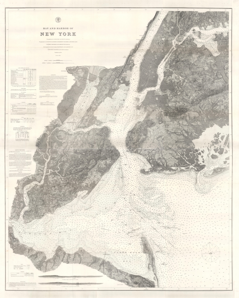
Bay and Harbor of New York.
1874 (dated) 51 x 41 in (129.54 x 104.14 cm) 1 : 40000
1874 (dated) 51 x 41 in (129.54 x 104.14 cm) 1 : 40000
Description
This 1874 double-sized nautical map of New York City represents the ultimate expression of the Coast Survey's work in and around New York harbor. Its refined detail provides not only state-of-the-art navigational information, but also a valuable record of land usage and development.
A Closer Look
Developed blocks in Manhattan, Brooklyn, Jersey City, Hoboken, and Elizabeth are clearly indicated with, in some cases, individual buildings marked. Even so, large undeveloped stretches of rolling hills in Brooklyn and Queens stand in sharp contrast with today's sprawl. The coastal topography is well-detailed and hachured, with terrain indicated. And certainly, the chart is replete with practical navigational information, including depth soundings, harbor descriptions, and navigation guides to important channels. Tables detailing lighthouses and beacons, tides, and magnetic declination, are included as well.Publication History
The triangulation for this chart was prepared by J. Ferguson and E. Blunt. The topography by H. L. Whiting, S. A. Gilbert, A. M Harrison, F. W. Door, C. Rockwell, and J. M. E. Chan. The hydrography was accomplished by R. Wainwright and T. A. Craven. The entire production was supervised by A. D. Bache, Superintendent of the Survey of the Coast of the United States and one of the most influential American cartographers of the 19th century.CartographerS
The Office of the Coast Survey (1807 - present) founded in 1807 by President Thomas Jefferson and Secretary of Commerce Albert Gallatin, is the oldest scientific organization in the U.S. Federal Government. Jefferson created the "Survey of the Coast," as it was then called, in response to a need for accurate navigational charts of the new nation's coasts and harbors. The spirit of the Coast Survey was defined by its first two superintendents. The first superintendent of the Coast Survey was Swiss immigrant and West Point mathematics professor Ferdinand Hassler. Under the direction of Hassler, from 1816 to 1843, the ideological and scientific foundations for the Coast Survey were established. These included using the most advanced techniques and most sophisticated equipment as well as an unstinting attention to detail. Hassler devised a labor intensive triangulation system whereby the entire coast was divided into a series of enormous triangles. These were in turn subdivided into smaller triangulation units that were then individually surveyed. Employing this exacting technique on such a massive scale had never before been attempted. Consequently, Hassler and the Coast Survey under him developed a reputation for uncompromising dedication to the principles of accuracy and excellence. Unfortunately, despite being a masterful surveyor, Hassler was abrasive and politically unpopular, twice losing congressional funding for the Coast Survey. Nonetheless, Hassler led the Coast Survey until his death in 1843, at which time Alexander Dallas Bache, a great-grandson of Benjamin Franklin, took the helm. Bache was fully dedicated to the principles established by Hassler, but proved more politically astute and successfully lobbied Congress to liberally fund the endeavor. Under the leadership of A. D. Bache, the Coast Survey completed its most important work. Moreover, during his long tenure with the Coast Survey, from 1843 to 1865, Bache was a steadfast advocate of American science and navigation and in fact founded the American Academy of Sciences. Bache was succeeded by Benjamin Pierce who ran the Survey from 1867 to 1874. Pierce was in turn succeeded by Carlile Pollock Patterson who was Superintendent from 1874 to 1881. In 1878, under Patterson's superintendence, the U.S. Coast Survey was reorganized as the U.S. Coast and Geodetic Survey (C & GS) to accommodate topographic as well as nautical surveys. Today the Coast Survey is part of the National Oceanic and Atmospheric Administration or NOAA as the National Geodetic Survey. More by this mapmaker...
Edmund March Blunt (June 20, 1770 - 1862) was an American navigator, bookseller, chartmaker, and cartographer based in Newburyport, Massachusetts. Blunt was born in Portsmouth, New Hampshire in 1770. In 1796, along with the nominal assistance of prominent navigator Captain Lawrence Furlong, Blunt published The American Coast Pilot, one of the most important published works on American navigation. Although much of the work was plagiarized from British publications, the Coast Pilot was an immediate popular success. In response to the popularity of his work, Blunt published 21 subsequent editions, each with important updates and revisions. The first edition to contain map plates was printed in 1804. Following a fire that destroyed his offices at The Sign of the Bible in 1811, Blunt moved his business to New York and opened a new shop, The Sign of the Quadrant. His sons Edmund Jr. (1799 - 1866) and George William (1802 - 1878), joined the firm in 1824 and eventually took over the family business, renaming the firm 'E. and G. W. Blunt'. They both produced their own nautical books, charts, and instruments, as well as republished their father’s work. In 1830, Edmund accepted a position under Ferdinand Hassler at the United States Office of the Coast Survey. Much of Blunt's original work eventually found its way into U.S. Coast Survey Publications. George closed the firm in 1872 and sold the plates and chart copyrights to the U.S. Coast Survey and the U.S. Navy Hydrographic Office. Due to the quality and detail of Blunt's work, revised editions of his most important charts were republished well into the 1880s. Learn More...
Ferdinand H. Gerdes (September 15, 1809 - June 27, 1884) was one of the most active members of the U.S. Coast Survey team. His most important work includes several surveys of New York Harbor as well as detailed surveys of Florida, the Gulf Coast, and up the Mississippi River. Gerdes was born in Hanover, Germany (Prussia) and relocated to the United States sometime before 1836, when he joined he fledgling U.S. Coast Survey as an Sub-assistant under Hassler. From 1841 - 1844 he surveyed the New Jersey, Maryland, Delaware Bay Region. In 1844 he was assigned to the Gulf Coast, where he produced his most important and pioneering work. During the American Civil War, like most of the members of the Coast Survey, Gerdes was strongly pro-Union and worked diligently during the Civil War to provide Union commanders accurate surveying and cartographic materials. Gerdes is known to have commanded the ‘Sachem' and, during the Civil War, was heavily engaged with Union efforts to map and ultimately control, the Mississippi River. Following the war he produced detailed surveys of the Passes of the Mississippi. His health and age catching up on him, Gerdes retired to New York, where he completed additional surveys of long island as late as 1883, a year before his death. Learn More...
Henry L. Whiting (1821-1897) worked for the United States Coast and Geodetic Survey for nearly 60 years, having joined in July of 1838. He began joining survey parties in 1842 and began a long and steady climb through the survey's hierarchy. By the 1850s he was acting as instructor in field surveys at the Naval Academy at Annapolis, and became Professor of Topographical Engineering in Massachusetts Institute of Technology. He proposed and executed he first systematic inspection of the survey's field work. He established many of the conventions in lettering and nomenclature which would be adopted by the survey going forward. His surveys included Florida; the Mississippi River; Provincetown Harbor and Boston Harbor; The Pacific coast from San Diego to Puget Sound; Portland, Maine; Providence Harbor in Rhode Island; and New York Harbor. With the outbreak of the Civil War, he was the first of the Survey then abroad to volunteer for service in Washington, and went on to make cooperative surveys with the Army throughout the war, in many cases surveying battlegrounds just after the close of action. Though born inland in Albany, New York, he was a lifelong resident of Martha’s Vineyard, and would regularly resurvey his home. He would in 1856 co-found the Martha’s Vineyard Agricultural Society. Learn More...
Source
Report of the Superintendent of the U.S. Coast Survey, (New York) 1874.
Condition
Good. Joined and mounted on linen. Wear and toning along original fold lines. Else very good.
References
OCLC 857548435.