This item has been sold, but you can get on the Waitlist to be notified if another example becomes available, or purchase a digital scan.
1800 Stockdale Map or Plan of the City of Berlin, Germany
Berlin-stockdale-1800$175.00

Title
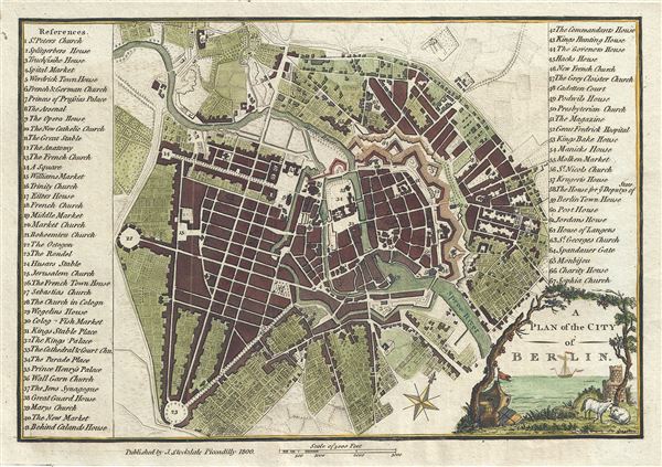
A Plan of the City of Berlin.
1800 (dated) 7.5 x 10 in (19.05 x 25.4 cm) 1 : 20000
1800 (dated) 7.5 x 10 in (19.05 x 25.4 cm) 1 : 20000
Description
This is an appealing 1800 map or city plan of Berlin, Germany, issued by John Stockdale. It beautifully depicts the capital city of the Kingdom of Prussia at the end of the 18th century. The map is exceptionally detailed, noting churches, streets, gates, fortifications, rivers and a host of additional topographical features.
At the time, Prussia and the German states were undergoing a cultural revolution along with the rest of Europe. Celebrities from across the continent would be seen in the city streets, among them famous Germans such as Johann Gottfried von Herder, Johann Wolfgang von Goethe, Friedrich Schiller and Joseph Haydn. Berlin became a center of the 'Age of Enlightenment' for the German intellectual elite who were increasingly leading European intellectual thought, reshaping popular culture. It would also benefit enormously from the Industrial Revolution.
This map was published by John Stockdale in 1800.
Cartographer
John Stockdale (March 25, 1750 - June 21, 1814) was an English book and map publisher active in London in the late 18th and early 19th centuries. Stockdale, born in Caldbeck, England, was trained by his father in the family trade of blacksmithing. Blacksmithing must not have been his cup of tea, for as soon as he was able, he left this trade in favor of a number of minor service positions, working at various times as a porter and a valet. One such position put him in the service of the bookseller John Almon. Having learnt the book trade by observing Almon, Stockdale opened his own bookshop and began publishing various historic and scientific works. Fellow publishers, perhaps reacting to his social status at birth, wrote of him, "being a man of natural parts, he soon became conspicuous in business in spite of much eccentricity of conduct and great coarseness of manners." Never quite accepted in the trade, Stockdale's fellow London publishers derogatorily referred to him as "The Bookselling Blacksmith". Nonetheless, Stockdale had a number of important works to his name, including several geographies, most notably the 1794American Geography 1794 and, with John Cary, the 1805 New British Atlas. More by this mapmaker...
Source
Stockdale, J., A geographical, historical and political description of the empire of Germany, Holland, the Netherlands, Switzerland, Prussia, Italy, Sicily, Corsica, and Sardinia, London, 1800.
Condition
Very good. Original platemark visible. Blank on verso.