
This item below is out of stock, but another example (left) is available. To view the available item, click "Details."
Details
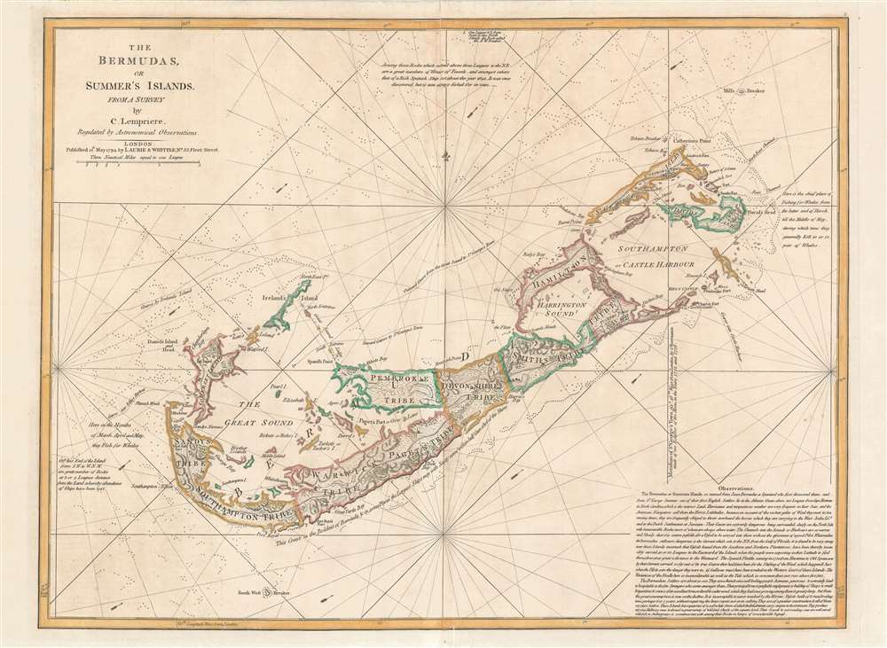
1775 / 1787 Sayer / Lemprière Map of Bermuda
1787 (dated) $4,000.00
1794 Lempriere Map of Bermuda
Bermuda-lempriere-1794$1,200.00

Title
The Bermudas, or Summer's Islands from a Survey by C. Lempriere, regulated by Astronomical Observations.
1794 (dated) 19 x 26 in (48.26 x 66.04 cm) 1 : 60000
1794 (dated) 19 x 26 in (48.26 x 66.04 cm) 1 : 60000
Description
This is the first commercial sea chart an map of Bermuda to incorporate data from Clement Lemprière's important survey of 1738. The map covers all of Bermuda and some of the adjacent seas. Crosses at sea illustrate the locations of shoals and reefs. The map features detailed topography, noting roads, nautical routes around the island, settlements, and more. Administrative districts, or 'Tribes' are identified throughout. In the lower right in a long block text of considerable value to the mariner.
Bermuda, a haven for smugglers
Lemprière was probably contracted by the governor of Bermuda to survey the island in an attempt to curb smuggling. By the 18th century Bermuda had become a mecca for smugglers. The small archipelago was conveniently located on the trade route between the West Indies and Europe. Free traders, pirates, and smugglers from all countries could conceal themselves in any of Bermuda's many hidden coves and bays and conduct trade without pay the East India Company tax. They could also use the hidden coves to trade with foreign nations under British embargo. The colonial governors tried in vain to stop the rampant smuggling, but with only a small military staff and a host of corrupt official, the effort proved hopeless.The Tribes of Bermuda
The Somers Isles company was founded by the shareholders of the Virginia Company formed in 1614. When the Virginia company folded in 1622, Somers Isles Company, with a separate charter, continued to administer Bermuda foe nearly six decades. Most of Bermuda was subdivided into eight equally sized administrative zones initially termed 'tribes,' later changed to 'parishes'. These were named for shareholders in the Company, and were further divided (by tribe roads) into lots equating to shares held. Saint George formed a ninth subdivision, now the eastern-most parish, incorporating Saint George's Island, Saint David's Island, part of the Main Island, and various smaller islands and islets around Castle Harbour (then known as Southampton Harbour) and Saint George's Harbour. This area was held in common by the Company shareholders and served as Bermuda's original capital, Saint George's Town. While Saint George Harbour was easily accessed by maritime merchants, the location of the capital made it difficult to administer the western part of the island, where smugglers and pirates were most active.Publication History and Census
The cartography here, as previously noted, dates to Clement Lemprière's important survey, the first modern survey of the archipelago and is considerable advancement upon the Richard Norwood's 1662 survey. It is unclear of the exact dates when Lemprière conducted his Bermuda survey, but it was most likely in the early 1720s. Lemprière's own map was engraved by Toms and published in 1738, but is today near unobtainable. In 1775 Robert Sayer engraved the first state of this map, the plate for which subsequently was acquired by the firm of Laurie and Whittle. Due to the accuracy of Lemprière's survey, and dearth of new information, this map was published in nautical atlas and issued separately until 1829. Examples are scarce to the market.CartographerS
Clement Lemprière (January 28, 1682 - July 9, 1746) was a Jerseyman sea captain, military engineer, cartographer, hydrographer, artist, and engraver active in the first half of the 18th century. Of note, most records suggest that Lemprière was born in 1683, but there can be no doubt that his birth was in 1682, as we have found his original baptismal records. We can only assume that 1683 was a transcription error that was subsequently copied by others. Lemprière was born on the isle of Jersey in the town of St. Helier. Little is known of his early life or education, but befitting the life of a sea captain, he was well traveled. There are unverified reports that he was a resident cartographer in charge of the Dawning Room at the Tower of London in 1725 and possibly a drawing tutor to Queen Anne. He is noted for drafting Henry Popple's important map of North America. He may have traveled to Bermuda sometime in the 1730s, as his name is attached to a landmark mapping of that archipelago, the first new map of Bermuda since the Nelson survey of 1660. By the 1740s he was in the British Army, where he was attached to the Engineering Corps. In 1741, he was appointed Chief Draughtsman of the Ordnance Office. His most acclaimed work is a set of sixteen sketches for the eleven tapestries of the Spanish Armada that once hung in the British Parliament. When the Parliament house burnt in 1834, the original tapestries were lost, leaving Lemprière's draft sketches as their only surviving record. More by this mapmaker...
Laurie and Whittle (fl. 1794 - 1858) were London, England, based map and atlas publishers active in the late 18th and early 19th century. Generally considered to be the successors to the Robert Sayer firm, Laurie and Whittle was founded by Robert Laurie (c. 1755 - 1836) and James Whittle (1757-1818). Robert Laurie was a skilled mezzotint engraver and is known to have worked with Robert Sayer on numerous projects. James Whittle was a well-known London socialite and print seller whose Fleet Street shop was a popular haunt for intellectual luminaries. The partnership began taking over the general management of Sayer's firm around 1787; however, they did not alter the Sayer imprint until after Sayer's death in 1794. Apparently Laurie did most of the work in managing the firm and hence his name appeared first in the "Laurie and Whittle" imprint. Together Laurie and Whittle published numerous maps and atlases, often bringing in other important cartographers of the day, including Kitchin, Faden, Jefferys and others to update and modify their existing Sayer plates. Robert Laurie retired in 1812, leaving the day to day management of the firm to his son, Richard Holmes Laurie (1777 - 1858). Under R. H. Laurie and James Whittle, the firm renamed itself "Whittle and Laurie". Whittle himself died six years later in 1818, and thereafter the firm continued under the imprint of "R. H. Laurie". After R. H. Laurie's death the publishing house and its printing stock came under control of Alexander George Findlay, who had long been associated with Laurie and Whittle. Since, Laurie and Whittle has passed through numerous permeations, with part of the firm still extant as an English publisher of maritime or nautical charts, 'Imray, Laurie, Norie and Wilson Ltd.' The firm remains the oldest surviving chart publisher in Europe. Learn More...
Condition
Very good. Light toning. Old color. Verso centerfold reinforcement.
References
Rumsey 4723.006.