
1595 Ortelius Map of Bourges, France and Environs

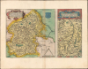
Regionis Biturgium... / Limaniae Topographia...
Between the Loire and Massif Central.
- Digital Map Information
- Suitable for large format printing
- Full resolution TIFF file
- ICC color profile embedded
- Delivered instantly via download link
Between the Loire and Massif Central.
This is a lovely, old-color 1595 Abraham Ortelius map of the historic regions of Berry and Limagne (in Auvergne) in central France. Around the time this map was produced, these regions, like much of Europe, were caught between opposing forces in the Wars of Religion.A Closer Look
The sheet is divided in two, with a larger (12 x 12.25 in.) map at left covering Berry, the capital of which is Bourges, situated south of the Loire River and north of the Massif Central, near the geographic center of France. Cities and towns, forests, rivers, castles, and other features are labeled throughout. At top-right is the region's coat of arms with fleurs de lis and the slogan 'Turribus a binis, inde vocor Bituris.' This map is derived from Ioannes Calamaeus (Jean Chaumeau), who wrote a history of Berry in 1566, and is based on Jean Jolivet's large 1545 map of the region.The smaller (12 x 6 in.) map at right covers the nearby region of Limagne in Auvergne, with a capital at Clermont, one of the oldest cities in France. The map is centered on the Allier River and records cities, towns, waterways, and mountains, which are illustrated. Ortelius based this map on one by Gabriel Symeoneus (Gabriel Symeoni, 1509-1570), who published a scientific text in 1561 that included a map of Limagne.
The verso includes historical and geographical descriptions of both regions.
Historical Context
The area of Central France seen in these two maps was caught up in the fighting of the French Wars of Religion of the late 16th century. Bourges was captured in 1562 by Huguenot forces led by Gabriel de Lorges, Count of Montgomery (1530 - 1574), but it was quickly recaptured by Catholic armies. A 1569 siege by Protestant forces failed and the town remained solidly Catholic thereafter, as did the wider region, with periodic bouts of anti-Protestant violence (as in the days following the St. Bartholomew's Day Massacre in Paris in 1572). Although turbulent and violent, the Wars of Religion arguably benefited Bourges and other nearby cities like Clermont as it drew them closer to the crown and brought patronage from the Church, leading to new educational institutions, palaces, and gardens.Publication History and Census
The present sheet appeared in the 1595 Latin edition of Ortelius' Theatrum Orbis Terrarum, of which 500 Copies were printed. The map was included in the first (1570) edition of the Theatrum and continued to appear until 1609. In its various printings, this piece is well-represented in institutional collections and occasionally appears on the market.Cartographer
Abraham Ortelius (April 14, 1527 - June 28, 1598) also known as Ortels, was a cartographer, geographer, and cosmographer of Brabant, active in Antwerp. He was the creator of the first modern atlas, Theatrum Orbis Terrarum and is a seminal figure in the history of cartography. Along with Gerard Mercator and Gemma Frisius, he was a founder of the Netherlandish school of cartography. His connections with Spain - culminating in his 1575 appointment as Royal Cartographer to King Phillip II of Spain - gave him unmatched access to Spanish geographical knowledge during a crucial period of the Age of Discovery. Ortelius was born in 1527 in Antwerp. In 1547 he entered the Antwerp Guild of Saint Luke as an illuminator of maps. He began trading in books, prints, and maps, traveling regularly to the Frankfurt book and print fair, where in 1554 he met Mercator. He accompanied Mercator on journeys throughout France in 1560 and it was at this time, under Mercator's influence, that he appears to have chosen his career as a scientific geographer. His first published geographic work appeared in 1564, an eight-sheet cordiform world map. A handful of other maps preceded the 1570 publication of the first edition of the Theatrum Orbis Terrarum, which would prove to be his life work. Appearing with but 53 maps in its first edition, Ortelius' work expanded with new maps added regularly. By 1592, it had 134 maps. Many of Ortelius' maps remained the standard for nearly a century. He traveled extensively, but his genius was as a compiler, locating the best informed maps on which to base his own. His contacts throughout Europe and extending even (via the Portuguese) to the Far East were formidable. Moreover, many of his maps were based on his own scholarship, particularly his historical works. His theories of geography were particularly ahead of his time with respect to the notion of continental drift, the possibility of which he mused on as early as 1596, and which would be proven correct centuries later. In a sense his greatest achievement was his successful navigation of the religious and political violence endemic to his city throughout his adult life: The Dutch Revolt, or Eighty Years' War (1568 - 1648), fully embroiled Antwerp. Although outwardly and officially recognized as Catholic (Arias Montanus vouched for Ortelius' Catholic orthodoxy prior to his appointment as Royal Geographer), Ortelius was able to separate himself from the religious furor which characterized the war in the low countries. Ortelius showed a glimpse of himself in a letter to a friend, regarding humanist Justus Lipsius: 'I do not know whether he is an adherent of the Pope or a Calvinist, but if he has ears to hear, he will neither be one nor the other, for sins are committed on both sides'. Ortelius' own explorations of Biblical history in his maps, and the Christogram contained in his own motto, suggest him to be a religious man, but his abjuration of political religious authorities mark him as an individualist. His tombstone at St Michael's Præmonstratensian Abbey in Antwerp bears the inscription, Quietis cultor sine lite, uxore, prole. ('served quietly, without accusation, wife, and offspring.') Further Details...
Source
Ortelius, A., Theatrum Orbis Terrarum, (Antwerp: Plantin) 1595.
Abraham Ortelius' magnum opus, Theatrum Orbis Terrarum, was the world's first regularly produced atlas, which 'set the standards for later atlases ... It was the first undertaking of its kind to reduce the best available maps to an uniform format.' (Koeman) A modestly-sized work of fifty-three maps in its first edition of May 1570, it was an immediate success: there were three further editions that year, and the work remained in print for a total of 32 editions, the last of which was 1641, well after its author's 1598 death. Ortelius added to his atlas constantly, and by 1595 the Theatrum contained 147 maps. Ortelius is renowned generally as an editor, and indeed much of the Theatrum is compiled from a variety of sources: in such cases, Ortelius was scrupulous in naming his sources. But Ortelius was also a mapmaker in his own right: many of his maps are a distillation of various sources into his own work, and there were many maps - particularly in his atlas of Biblical and ancient history Parergon - which were entirely Ortelius' work. In his role as an editor, Ortelius followed in the footsteps of Munster, whose Cosmographia was, until Ortelius, the best window on the world for the curious European reader. In terms of the artistry of his maps, Ortelius oversaw the first great flourishing of copperplate engraving in the service of cartography to occur in Northern Europe. Ortelius' work provided the model for the atlases of Mercator, Hondius, Blaeu and all their progeny in the 17th century - many of whom were to produce faithful editions of Ortelius' maps in their own productions.
Condition
Very good. Light toning along centerfold.
References
Rumsey 10000.029 (1570 ed.).