This item has been sold, but you can get on the Waitlist to be notified if another example becomes available, or purchase a digital scan.
1874 Ludlow and Custer Geological Map of the Black Hills, South Dakota (Little Big Horn)
BlackHillsG-ludlow-1874$250.00

Title
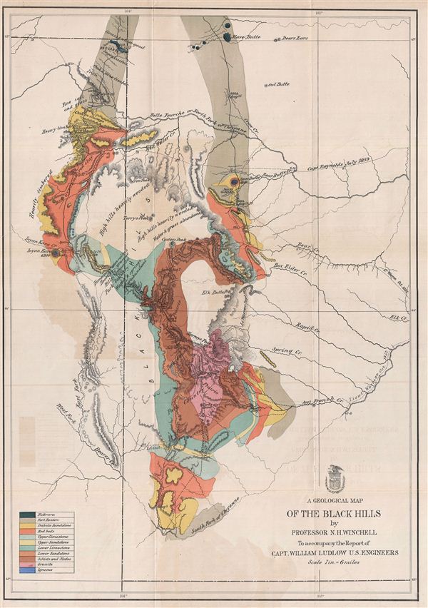
A Geological Map of the Black Hills.
1874 (undated) 26 x 19 in (66.04 x 48.26 cm)
1874 (undated) 26 x 19 in (66.04 x 48.26 cm)
Description
This is a rare example of the 1875 geological map of the Black Hills, South Dakota prepared for the official report on the Custer expedition of 1874. Centered on Harney's Peak, the highest point in the Black Hills, the map covers from Slave Butte to the South Fork of Cheyenne River. Various mountain peaks, wooded areas, creeks, prairies, and other topographical details are also noted. encompassing the Black Hill National Forest, the Black Hills are famous for being home to the Mount Rushmore National Memorial, Custer State Park, Crazy Horse Memorial and other attractions. The routes of Lt. Warren, 1857, Capt. Reynolds, 1859, and the route taken for reconnaissance by Capt. Ludlow, 1857, are marked.
Captain William Ludlow, accompanied by Prof. N. H. Winchell (State Geologist of Minnesota) and Mr. George Bird Grinnell, penetrated the region in 1874, attached to the Seventh Cavalry under command of Lieutenant Colonel George Armstrong Custer as part of the United States Army expedition to explore the uncharted Black Hills and South Dakota in order to identify a suitable site for a fort, explore the possibility of gold mining in the region, and find a route to the southwest. Together they produced the rare Report of Reconnaissance of the Black Hills of Dakota, made in the summer of 1874, which essentially opened up the Dakota Territory. The land was originally promised to the Sioux Indians, who considered it sacred, but after the discovery of gold during this expedition, thousands of miners flooded into the region setting the stage for the Great Sioux War of 1876. Two years after this map was made, the Sioux Indians would kill Colonel Custer in the ill-fated battle of the Little Big Horn.
This map was issued to accompany the Report of Reconnaissance of the Black Hills of Dakota, made in the summer of 1874, of which only 2500 copies were printed.
CartographerS
William Ludlow (November 27, 1843, - August 30, 1901) was an officer in the Corps of Engineers and a major general in the United States Army who served in the American Civil War, the Plains Indian Campaigns, the Spanish-American War, and led a scientific expedition examining the natural wonders of Yellowstone National Park. Ludlow was born in Islip, Long Island, and attended both the City University of New York and the United States Military Academy at West Point. Ludlow excelled at engineering and science and, upon graduation, was immediately assigned to the Army Corps of Engineers. During the American Civil War he served on the staff of General Sherman and participated in both Sherman's March and the Carolina Campaign. Following the Civil War, Ludlow was ordered to the staff of Lt. Col. George Armstrong Custer, who had been dispatched to the Black Hills of Dakota to search for gold. Unlike Custer, Ludlow survived the Black Hills and went on to a distinguished military career, serving in Cuba and in the Philippines before taking an honorable retirement. Ludlow retired to Convent, New Jersey, where he died at 56. He is buried in Arlington National Cemetery. More by this mapmaker...
Army Corps of Topographical Engineers (fl.1838 - 1863) refers to the an elite branch of the U.S. Army created on July 4, 1838 to perform civil mapping and survey work throughout the United States. The origins of the Corps of Topographical Engineers can be traced back to the American Revolutionary War, where General George Washington recognized the need for accurate surveys pursuant to military action. Shortly following the war, in 1779, a civilian engineering corps was created by act of Congress. Identified in 1802 by Thomas Jefferson, the "Corps of Engineers," which was based at West Point, the group participated in the War of 1812 and in later in the fortification of New Orleans. It was not until 1838, however, that a separate group of "Topographical Engineers" was formally recognized. This elite group, consisting only of officers, most of whom were trained in surveying and engineering by the esteemed Andrew Ellicott at West Point, never numbered more than 36 individuals - the best and brightest. This small but determined group played a central role in the mapping and exploration of the American West. Few branches of the military can boast such a distinguished alumni. Their names resonate throughout the map of the west and include John Charles Fremont, Zebulon Pike, George Meade, Kemble Warren, William Amiel Weeks, A. B. Gray, Randolph B. Marcy, James H. Simpson, Howard Stansbury, John W. Gunnison, William Ludlow, and Robert S. Williamson. The onset of the American Civil War brought an abrupt end to the surveying activity of the Topographical Engineers. Many of the most prominent engineers went on to distinguished military careers on both sides of the War Between the States. The Army Corps of Topographical Engineers itself was folded into the Corps of Engineers on March 31, 1863. Though the Army Corps of Engineers continues to do military and civil survey work to this day, the elite club of adventures that formed the Topographical Engineers were no more. Learn More...
Source
Ludlow, W., Report of Reconnaissance of the Black Hills of Dakota, made in the Summer of 1874, First Edition (Washington, 1875).
Condition
Very good. Original fold lines visible. Minor wear along folds. Verso reinforcement near left margin. Offsetting. Blank on verso. Professionally flattened and backed with archival tissue.
References
Wheat, Carl Irving, Mapping of the Transmississippi West, 1540-1861, 1251.