This item has been sold, but you can get on the Waitlist to be notified if another example becomes available, or purchase a digital scan.
1545 / 1550 Munster Map of Bohemia (Czech): Earliest Acquirable Bohemia Map
Bohemia-munster-1545-2$325.00


Title
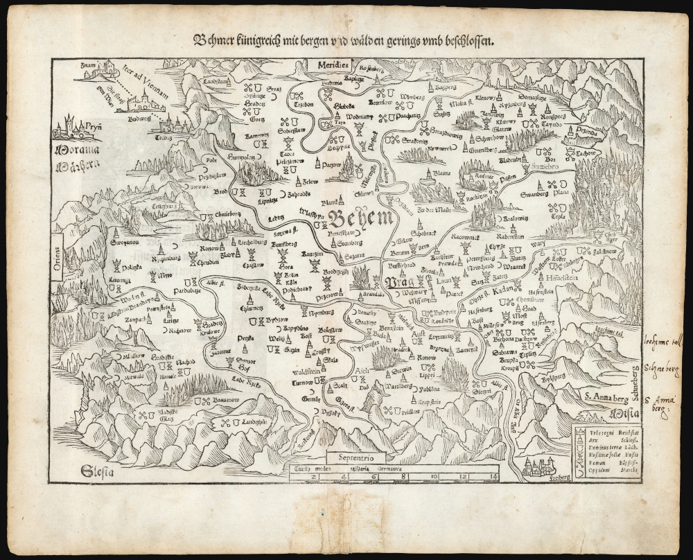
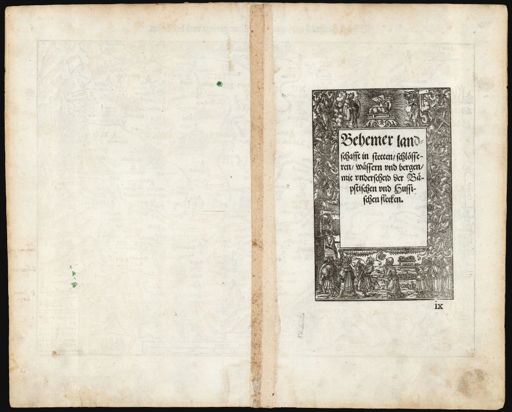
Behmer kunigreich mit bergen und waelden gerings umb beschlossen.
1545 (undated) 10.5 x 14 in (26.67 x 35.56 cm) 1 : 640000
1545 (undated) 10.5 x 14 in (26.67 x 35.56 cm) 1 : 640000
Description
This is Munster's 1545 map of Bohemia, the earliest acquirable printed map of what is now the Czech Republic. This map appeared in the 1572 Latin edition Munster’s Cosmographia Universalis, a work notable for presenting to a broad lay audience many of the first printed maps based on contemporaneous surveys and toponymy, rather than data from classical sources. Munster’s source for this map was Nicolaus Claudianus’ 1518 map of Bohemia, which now exists in only one known surviving example. Munster's map is the only version of Claudianus' map available to the collector.
First Map to Use a Key
This map is the first known to use a key with symbols to reflect the political, religious and economic terrain. Nordenskiold called this 'the first map on which the different religious and political conditions of a country are denoted'. With the key, Royal cities, seats of landed nobility, castles, and market towns are easily distinguished. Also, each town's religious affiliation is marked with either keys (signifying Roman Catholic) or a stylized chalice (representing The Unity of Czech Brethren, a Hussite protestant sect to which Claudianus belonged). Bohemia's long and contentious Reformation history would have made this feature on the Claudianus map one of singular importance. None of these remarkable details were lost on Munster, who retained all on his version of the map.North at the Bottom
The map’s southern orientation, while unusual to modern eyes, would not have been confusing to the 16th century reader. Maps produced in and around Germany in the first part of the sixteenth century, travelers’ maps in particular, were designed to be read with the assistance of solar compasses. These devices orient their users (in the northern hemisphere) toward the south. Consequently, this and many of Munster’s other maps based on modern survey share a southern orientation. Indeed, the original 1518 Claudianus is itself oriented to the south.Publication History and Census
This map was introduced in the 1545, Latin edition of Geographia Universalis; it remained in that work and was included in the subsequent Cosmographia Universalis, until 1578 when the double-page maps of the long-lived work were replaced and updated. This state of the map corresponds to the 1572 Latin edition of the Cosmographia, which is well represented in institutional collections. The individual map from this edition is only cataloged once in OCLC, at the Bayerische Staatsbibliothek.CartographerS
Sebastian Münster (January 20, 1488 - May 26, 1552), was a German cartographer, cosmographer, Hebrew scholar and humanist. He was born at Ingelheim near Mainz, the son of Andreas Munster. He completed his studies at the Eberhard-Karls-Universität Tübingen in 1518, after which he was appointed to the University of Basel in 1527. As Professor of Hebrew, he edited the Hebrew Bible, accompanied by a Latin translation. In 1540 he published a Latin edition of Ptolemy's Geographia, which presented the ancient cartographer's 2nd century geographical data supplemented systematically with maps of the modern world. This was followed by what can be considered his principal work, the Cosmographia. First issued in 1544, this was the earliest German description of the modern world. It would become the go-to book for any literate layperson who wished to know about anywhere that was further than a day's journey from home. In preparation for his work on Cosmographia, Münster reached out to humanists around Europe and especially within the Holy Roman Empire, enlisting colleagues to provide him with up-to-date maps and views of their countries and cities, with the result that the book contains a disproportionate number of maps providing the first modern depictions of the areas they depict. Münster, as a religious man, was not producing a travel guide. Just as his work in ancient languages was intended to provide his students with as direct a connection as possible to scriptural revelation, his object in producing Cosmographia was to provide the reader with a description of all of creation: a further means of gaining revelation. The book, unsurprisingly, proved popular and was reissued in numerous editions and languages including Latin, French, Italian, and Czech. The last German edition was published in 1628, long after Münster's death of the plague in 1552. Cosmographia was one of the most successful and popular books of the 16th century, passing through 24 editions between 1544 and 1628. This success was due in part to its fascinating woodcuts (some by Hans Holbein the Younger, Urs Graf, Hans Rudolph Manuel Deutsch, and David Kandel). Münster's work was highly influential in reviving classical geography in 16th century Europe, and providing the intellectual foundations for the production of later compilations of cartographic work, such as Ortelius' Theatrum Orbis Terrarum Münster's output includes a small format 1536 map of Europe; the 1532 Grynaeus map of the world is also attributed to him. His non-geographical output includes Dictionarium trilingue in Latin, Greek, and Hebrew, and his 1537 Hebrew Gospel of Matthew. Most of Munster's work was published by his stepson, Heinrich Petri (Henricus Petrus), and his son Sebastian Henric Petri. More by this mapmaker...
Mikuláš Klaudyán (Lat. Nicolas Claudianus, died 1522) was a Bohemian physician and scholar, sometime publisher, and member of the Czech or Bohemian Brethren, a Protestant group formed in 1457 rooted in the teachings of Jan Hus. He printed the oldest map of Bohemia in 1518, hailed by Nordenskjold as 'the first map on which the different religious and political conditions of a country are denoted.' Learn More...
Source
Munster, S., Cosmographei oder beschreibung aller länder..., (Basel: Petri) 1550.
The Cosmographia Universalis, one of the greatest geographical and historical works of the 16th century, 'taught nearly three generations of laymen most of what they knew about the world beyond their native places' (Strauss). Filled with maps, views, and rich descriptions of places throughout Europe and beyond, it was the best general source of geographical information until the advent of Ortelius' Theatrum. It was first issued by Sebastian Munster (1488 - 1552) in its 1544 German edition, and stayed in print long after its author's death in thirty five editions, and in five languages. (Of these, the 1550 and 1552 editions are widely regarded as the most complete and truest to the author's intentions: thereafter, later editors continued to add to the work's text; editions from 1588 onwards employed an entirely different set of maps produced on Ortelius' model.) Munster's goal, initially, was to rally his homeland's humanists and scholars to produce a new map of Germany in order to 'see what kind of a land our ancestors conquered for their home... bring honor to our country and place its beauties in the clear light of day.' Munster's project quickly expanded to cover the known world in its scope to produce a 'sufficiently large volume, in which I touch upon the foundation of all nations and kingdoms, their peculiarities, rivers, mountains, customs of men, royal successions, origins of the more important cities, succinct histories, religions, characteristics and fertility of lands... in Germany, however, I tarry a little longer'.
Munster's methodology in Cosmographia is notable in particular for his dedication to providing his readers with direct access to firsthand reports of his subjects wherever possible. Many of the maps were the result of his own surveys; others, the fruit of an indefatigable letter writing campaign to scholars, churchmen and princes throughout Europe, amicably badgering them for maps, views, and detailed descriptions of their lands. For lands further afield than his letters could reach, Munster relied on the best that the authorities of northern European scholarship could offer: he was well familiar with the work of Waldseemuller and other geographers of the early 16th century, and was well connected with the best geographers of his own generation. A disproportionate number of the maps of Cosmographia show contemporary geographical knowledge of the their respective areas for the very first time: The first map to show the continents of the Western Hemisphere; the first map to focus on the continent of Asia; the first modern map to name the Pacific Ocean; the first map to use a key; the first modern map of the British Isles and so on. Even in cases where earlier maps exist, Munster's works very often remain the earliest such acquirable by the collector.
Munster's methodology in Cosmographia is notable in particular for his dedication to providing his readers with direct access to firsthand reports of his subjects wherever possible. Many of the maps were the result of his own surveys; others, the fruit of an indefatigable letter writing campaign to scholars, churchmen and princes throughout Europe, amicably badgering them for maps, views, and detailed descriptions of their lands. For lands further afield than his letters could reach, Munster relied on the best that the authorities of northern European scholarship could offer: he was well familiar with the work of Waldseemuller and other geographers of the early 16th century, and was well connected with the best geographers of his own generation. A disproportionate number of the maps of Cosmographia show contemporary geographical knowledge of the their respective areas for the very first time: The first map to show the continents of the Western Hemisphere; the first map to focus on the continent of Asia; the first modern map to name the Pacific Ocean; the first map to use a key; the first modern map of the British Isles and so on. Even in cases where earlier maps exist, Munster's works very often remain the earliest such acquirable by the collector.
Condition
Very good. Few marginal mends and filled wormholes impacting title only.
References
OCLC 21787094. Nordenskiold, Facsimile Atlas, p.25. McLean, Matthew The Cosmographia of Sebastian Munster: Describing the World in the Reformation (Ashgate), 2007. Ruland, Harold L. 'A Survey of the Double-page Maps in Thirty-Five Editions of the Comographia (sic) Universalis 1544-1628 of Sebastian Munster and in his Editions of Ptolemy's Geographia 1540-1552' in Imago Mundi XVI 1962.