This item has been sold, but you can get on the Waitlist to be notified if another example becomes available, or purchase a digital scan.
1879 British Admiralty Chart or Map of Bombay Harbor, India ( Mumbai )
BombayHarbor-admiralty-1879$350.00

Title
Bombay Harbour
1879 (dated) 39 x 25 in (99.06 x 63.5 cm)
1879 (dated) 39 x 25 in (99.06 x 63.5 cm)
Description
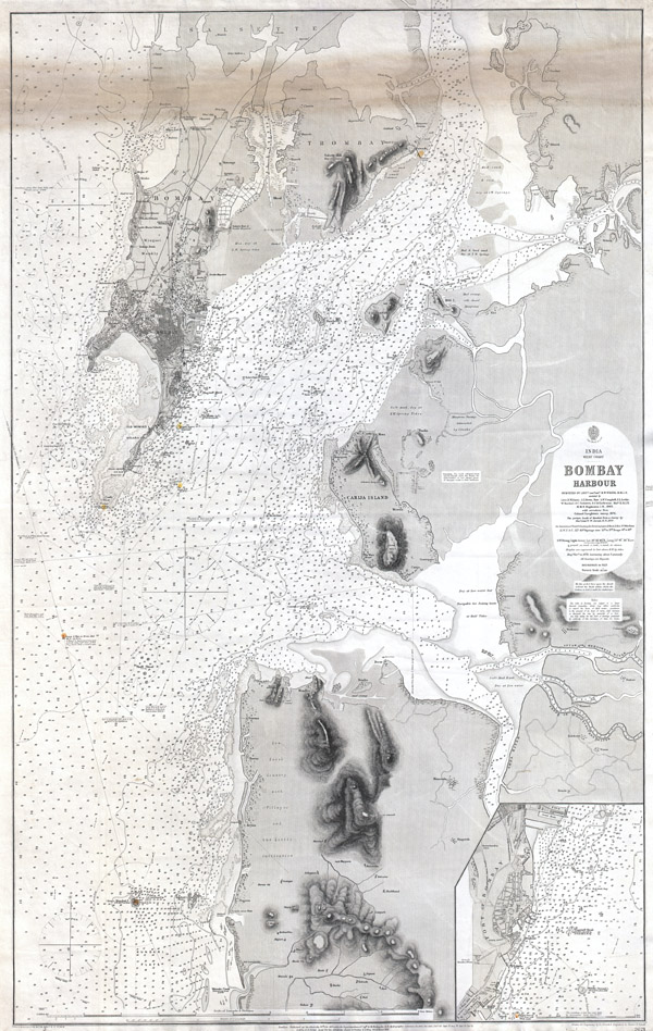
A rare and extraordinary 1879 nautical chart or map of Bombay (Mumbai) Harbor, India prepared by the British Admiralty. Offers extraordinary detail of Bombay harbor from Salsette in the north to Warsole Creek and Veshvee in the south. The city and peninsula of Bombay are beautifully rendered to the level of individual buildings. Notes piers, dock, lighthouses, the observatory, life boat locations, the Lunatic Asylum, the mint, and various workshops and palaces. Miniature palm trees and fields dot the coastline. Also notes topographical features, under sea shoals, swamps, ancient ruins, and forts. The harbor and rivers are dotted with near countless depth soundings in feet. An inset in the lower left hand quadrant details the Fort of Bombay from Old Woman's Island to Carnac Basin. Shows Cornwallis' Statues, the Arsenal, the Coal Depot, the Sepoy Lines, the Marine Battalion Lines, and the Castle. This chart was originally published by the Admiralty in 1864 under the direction of Captain G. H. Richards, Hydrographer. It was updated periodically until 1879 to reflect the work of R. W. Wish, R. Williams, A. L. Brown, A.W. Campbell, Colonel Laughton, and F. W. Jarad. Represents Admiralty Chart no. 2621.
Cartographer
The British Admiralty Office (1795 - Present) or the United Kingdom Hydrographic Office refers to the Branch of the English government that is responsible for the command of the British Navy. In 1795 King George III created the United Kingdom Hydrographic Office, known in short as the U.K.H.O., to provide top notch nautical charts to the vast Royal Navy. Prior the founding of the Admiralty the surveying and creation of nautical charts was primarily a commercial venture wherein the cartographer himself, more of than not, actually financed the printing of his own material. The great navigator Cook himself is known to have scrambled for funds to publish his own seminal charts - the most important and advanced of the period. The system of privately funded nautical mapping and publishing left vast portions of the world uncharted and many excellent charts unpublished. King George III, responding significant loss in trade revenue related to shipwrecks and delay due to poor charts, recognized the need for an institutionalized government sponsored cartographic agency - the Admiralty. The first head of the Admiralty, a position known as Hydrographer, was the important cartographer Alexander Dalrymple. Dalrymple started by organizing and cataloging obtainable charts before initiating the laborious process of updating them and filling in the blanks. The first official Admiralty Chart appeared in 1800 and detailed Quiberon Bay in Brittany. By 1808 the position of Hydrographer fell to Captain Thomas Hurd. Hurd advocated the sale of Admiralty charts to the general public and, by the time he retired in 1829, had issued and published some 736 charts. Stewardship of the organization then passed to Rear Admiral Sir Francis Beaufort. It was under Beaufort's administration that the Admiralty truly developed as a "chart making" as opposed to a "chart cataloging" institution. Beaufort held his post from 1829 to 1854. In his 25 years at the Admiralty Beaufort created nearly 1500 new charts and sponsored countless surveying and scientific expeditions - including the 1831 to 1836 voyage of the H.M.S. Beagle. By 1855 the Admiralty's chart catalog listed some 1,981 charts. More by this mapmaker...
Condition
Good condition. This map is all in all, in extraordinary condition. However, there is a discoloration along the top of the map, see photo, that we have not been able to remove. Normally as 1200 USD chart, discounted to 700 to reflect area of discoloration.