1872 Petermann Map of Borno, Nigeria, Cameroon, Chad
Borno-petermann-1872$300.00

Title
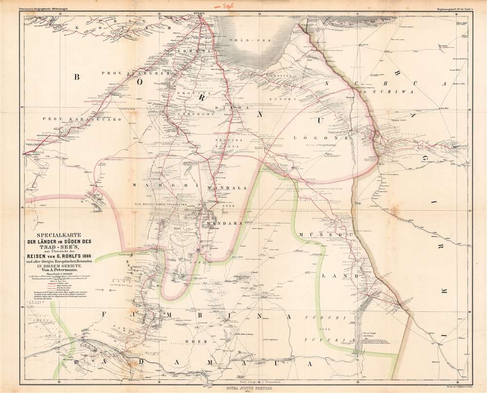
Specialkarte der Länder im Süden des Tsad-See's...
1872 (undated) 20.25 x 24.5 in (51.435 x 62.23 cm) 1 : 800000
1872 (undated) 20.25 x 24.5 in (51.435 x 62.23 cm) 1 : 800000
Description
This is August Petermann's 1872 map of what is today the Borno (or Bornu) region of Nigeria and neighboring territories, sitting at the meeting point of Nigeria, Cameroon, and Chad along the southern banks of Lake Chad. In the years and decades following this map's publication, this region would play an important role in the Scramble for Africa.
The French commander, Amédée-Francois Lamy, was also killed in the battle and a French fort established nearby, where the Lognoe River meets the Chari River, was named in his honor. The site, noted here as 'Siña-Fatscha, Schéggua, od. Kindja-Burga,' became the major military and administrative center of the region. After Chad gained independence, it was made the country's capital and renamed N'Djamena in 1973. Lamy's death in fact came at the end of a long expedition led by himself and Fernand Foureau, an explorer very familiar with the Sahara. Their goal, which Lamy achieved, albeit at the cost of his life, was to unify French territory in west, central, and north Africa via the Chad Basin.
It is worth noting that most of what is today Cameroon and parts of neighboring countries became the German colony of Kamerun in the 1880s, while the British pressed into the region from Nigeria in the west. Those colonies notwithstanding, the Battle of Kousseri cemented France's dominance over most of West and Equatorial Africa. Along with the Fashoda Incident a couple years earlier, it can be seen as the end of the Scramble for Africa, as nearly the entire continent was by then claimed by one or another European power. At that point, African colonization moved into a phase of 'pacification,' as European powers cemented their control.
A Closer Look
This map traces the routes of several European explorers from the 1820s - 1860s, namely Gerhard Rohlfs, Major Dixon Denham, Dr. Heinrich Barth, Dr. Adolf Overweg, and Eduard Vogel. Vogel's route, partially unknown and otherwise overlapping with Barth and Rohlfs, was not originally illustrated, but a previous owner added it in, explaining the annotation in the top margin. In addition to the explorers' routes (red lines), areas of elevation, rivers, lakes, terrain (such as wetlands), settlements, and paths or roads are indicated. Explanatory notes drawn from the accounts of the explorers on the peoples and geography of various locations are included.Historical Context
At the time this map was produced, most of this area was ruled by the Kanem-Bornu Empire, which existed in some form since the 8th century. The empire had declined in the 18th century and its capital of Ngazargamu was overrun in 1809 by Fulani warriors. It was soon after reconstituted by Muhammad al-Amin al-Kanemi, who founded a new capital at Kukawa, here as 'Kukaua' at top-left (the city is now far from the lake's shore, showing its recession over the years). However, this revival was short-lived; Kukawa was captured by the Sudanese warlord Rabih az-Zubayr in 1893 and then by the British in 1902.Scramble for Africa
The Scramble for Africa was mainly characterized by heightened occupation and direct ownership of colonial lands. Rivalries and treaties led to a number of new African states, many of which remain, but few of which paid heed to traditional boundaries or cultural distinctions. Though there were early actions in years prior, the Scramble began in earnest at the Berlin Conference of 1884, wherein European colonization of Africa was regulated, and the doctrine of Effective Occupation introduced. In the following months and years, European military officers, administrators, and businessmen raced to sign treaties with indigenous leaders establishing protectorates and gaining mining rights on their lands. The more ambitious of these colonial entrepreneurs imagined transcontinental strings of colonies, such as Cecil Rhodes' famous notion of 'the Cape to Cairo,' the Portuguese 'Pink Map' plot linking Angola and Mozambique, and French efforts to tie together their growing number of African colonies.French Equatorial and West Africa
French presence in the region was cemented by a battle at Kousseri (Kússuri) towards top-right, now Cameroon, in 1900. There, the French defeated the powerful warlord Rabih az-Zubayr, killing him.The French commander, Amédée-Francois Lamy, was also killed in the battle and a French fort established nearby, where the Lognoe River meets the Chari River, was named in his honor. The site, noted here as 'Siña-Fatscha, Schéggua, od. Kindja-Burga,' became the major military and administrative center of the region. After Chad gained independence, it was made the country's capital and renamed N'Djamena in 1973. Lamy's death in fact came at the end of a long expedition led by himself and Fernand Foureau, an explorer very familiar with the Sahara. Their goal, which Lamy achieved, albeit at the cost of his life, was to unify French territory in west, central, and north Africa via the Chad Basin.
It is worth noting that most of what is today Cameroon and parts of neighboring countries became the German colony of Kamerun in the 1880s, while the British pressed into the region from Nigeria in the west. Those colonies notwithstanding, the Battle of Kousseri cemented France's dominance over most of West and Equatorial Africa. Along with the Fashoda Incident a couple years earlier, it can be seen as the end of the Scramble for Africa, as nearly the entire continent was by then claimed by one or another European power. At that point, African colonization moved into a phase of 'pacification,' as European powers cemented their control.
Publication History and Census
This map was prepared by August Petermann and printed by Carl Hellfarth of Justus Perthes. It appeared in 1872 as Plate I in Supplemental Booklet (Ergänzungsheft) No. 34 to Petermann's geographische Mittheilungen. It is independently cataloged among the holdings of five institutions in the OCLC, while Petermann's geographische Mittheilungen is somewhat more widely dispersed, especially in Germany.CartographerS
August Heinrich Petermann (1822 - 1878) was a German cartographer. Petermann attended the 'Geographische Kuntschule' (Geographica School of Art), which was started by Heinrich Berghaus with the support of Alexander von Humboldt, in Potsdam beginning in 1839. Students at the school were obliged to work on many of the school's contracts, including maps for several different atlases. Following his time in Potsdam, Petermann relocated to Edinburgh and London from 1845 to 1854, where he gained insight into the commercial aspects of the cartography business. In 1854, Petermann returned to Gotha, Germany and began working with the Perthes brothers publishers. While working with the Perthes brothers, Petermann founded the journal Petermanns Geographische Mitteilungen, published from 1855 until 2014, long one of the most prominent German-language geography journals. More by this mapmaker...
Johan Georg Justus Perthes (September 11, 1749 - May 2, 1816) was one of the most important German cartographic engravers of the 19th century. He was born in the Thuringian town of Rudolstadt, the son of a court physician. In 1778, he began working as a bookseller in Gotha. Perthes began his publishing empire shortly thereafter with the 1784 issue of the famed survey of European nobility known as the Almanac de Gotha. In the next year, 1785, he founded the cartographic firm of Justus Perthes Geographische Anstalt Gotha. His son Wilhelm Perthes (1793 - 1853) joined the firm in 1814. Wilhelm had prior publishing experience at the firm of Justus Perthes' nephew, Friedrich Christoph Perthes, who ran a publishing house in Hamburg. After Justus Perthes died in 1816, Wilhelm took charge and laid the groundwork for the firm to become a cartographic publishing titan. From 1817 to 1890. the Perthes firm issued thousands of maps and more than 20 different atlases. Along with the visionary editors Hermann Berghaus (1797 - 1884), Adolph Stieler (1775 - 1836), and Karl Spruner (1803 - 1892), the Perthes firm pioneered the Hand Atlas. When Wilhelm retired, management of the firm passed to his son, Bernhardt Wilhelm Perthes (1821 – 1857). Bernhardt brought on the cartographic geniuses August Heinrich Peterman (1822 - 1878) and Bruno Hassenstein (1839 - 1902). The firm was subsequently passed to a fourth generation in the form of Berhanrd Perthes (1858 – 1919), Bernhard Wilhelm's son. The firm continued in the family until 1953 when, being in East Germany, it was nationalized and run as a state-owned enterprise as VEB Hermann Haack Geographisch-Kartographische Anstalt Gotha. The Justus family, led by Joachim Justus Perthes and his son Wolf-Jürgen Perthes, relocated to Darmstadt where they founded the Justus Perthes Geographische Verlagsanstalt Darmstadt. Learn More...
Carl Hellfarth (November 30, 1846 - July 12, 1918) was a German printer. Hellfarth was born in Gotha, Germany. He married Amalie Friederike Marie Möller (1850 - 1916) on June 16, 1873, and they had eight children. Learn More...
Condition
Good. Foxing along fold lines and in upper margin. Wear at fold intersections.
References
OCLC 124077437, 556867767, 494969141.