
1738 Homann Heirs Map of the Balkans: Bosnia and Croatia

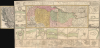
Theatrum belli inter imperat. Carol VI et sult. Achmet IV in partibus regnorum Serviae et Bosniae ex authenticis subsidys delineatum a Ioh. Fr. Ottingero. / Regnum Bosniae, una cum finitimis Croatiae, Damatiae, Slavoniae, Hung et Servia partibus… / Regni Servia una cum finitimis Valachiae et Bulgariae partibus…
Forgotten Austro-Turkish War of 1737-39.
- Digital Map Information
- Suitable for large format printing
- DPI: 600
- File Size: 83.1 MB
- File Type: ZIP / TIFF
- ICC color profile embedded
- Delivered instantly via download link
Forgotten Austro-Turkish War of 1737-39.
This is an uncommon large-format c. 1739 Homann Heirs map of the Balkans drawn by the royal military engineer Johann Friedrich (Franz) Ottinger (fl. c. 1736 - 1765). It is superbly detailed and includes two dozen insets of cities and fortifications, illustrating the events of the Austro-Turkish War of 1737 - 1739.A Closer Look
Coverage extends from the Dalmatian coast to Walachia and from Rijeka (Fiume) on the Kvarnar Gulf to the city of Nissa, including Bosnia, Serbia, Croatia, and parts of Slovenia and Bulgaria. The central map is titled 'Theatrum belli inter imperat. Carol VI et sult. Achmet IV in partibus regnorum Serviae et Bosniae.' It notes cities and towns, fortifications, waterways (including the Danube River at the top), the Tsarigrad Road (also known as the 'Road to Istanbul'), mountains, and forests. Major territories are color-shaded for easy distinction. Both the title of the central map at the top-right and the scale at the bottom-left include decorative cartouches, with both mythological figures and representations of Turkish soldiers. A legend explaining the meaning of the different letters appears at the top right.Twenty-five views and plans surround the map, illustrating cities and fortresses along rivers, including Banialucka (Banja Luka), Belgrade (Beogad), Brodt (Slavonski Brod), Carlstadt (Karlovac), Chatchek (Cacak), Esseck (Osijek), Krakoievaz (Kragujevac), Nicopolis (Nikopol), Nissa (Niš), Orsava (Orsova), Peterwardin (Petrovaradin), Ratscha (Rača), Sabatz (Sabac), Seraglio (Sarajevo), Temeswar (Timisoara), Ussitza (Uzice), Valiova (Valjevo), Vipalancka (Palanka), Widdin (Vidin), Wihaz (Bihac), and Zwornek (Zvornik). There is an unusual extra piece on the left side that expands coverage to include Dalmatia. Few examples of the map retain the foldout.
Austro-Turkish War (1737 - 1739)
In the long list of conflicts between the Habsburg (Austrian) Empire and the Ottoman Empire, this war is often barely a footnote. The war was an extension of the Russo-Turkish War (1735 - 1739). Under Habsburg Charles VI (1685-1740), Austria entered the war as an ally of Russia, which led to Austro-Turkish conflicts in the Balkans. Austrian forces proved ineffective against the Turks, despite the Ottomans fighting a two-front war. In the Balkans, Austria lost the Battle of Banja Luka in August 1737 and the Battle of Grocka in July 1739, and was driven out of Belgrade after an Ottoman siege from July to September 1739. Austria finally signed the Belgrade Peace on September 18, 1739.Publication History and Census
Most scholarship dates this map to 1736; however, our research of the events depicted suggests a later date of 1739. Many surviving examples do not have the foldout. This map appears to have been issued separately but is often found bound into various Homann atlases. Surviving examples are well represented in institutional collections, although it is difficult to determine exact publication dates for cataloged examples or whether they include the foldout.Cartographer
Homann Heirs (1730 - 1848) were a map publishing house based in Nuremberg, Germany, in the middle to late 18th century. After the great mapmaker Johann Baptist Homann's (1664 - 1724) death, management of the firm passed to his son Johann Christoph Homann (1703 - 1730). J. C. Homann, perhaps realizing that he would not long survive his father, stipulated in his will that the company would be inherited by his two head managers, Johann Georg Ebersberger (1695 - 1760) and Johann Michael Franz (1700 - 1761), and that it would publish only under the name 'Homann Heirs'. This designation, in various forms (Homannsche Heirs, Heritiers de Homann, Lat Homannianos Herod, Homannschen Erben, etc..) appears on maps from about 1731 onwards. The firm continued to publish maps in ever diminishing quantities until the death of its last owner, Christoph Franz Fembo (1781 - 1848). Further Details...
Condition
Very good. Even warm toning. Some minor edge reinforcements along original fold lines.
References
OCLC 781232275.