
This item below is out of stock, but another example (left) is available. To view the available item, click "Details."
Details
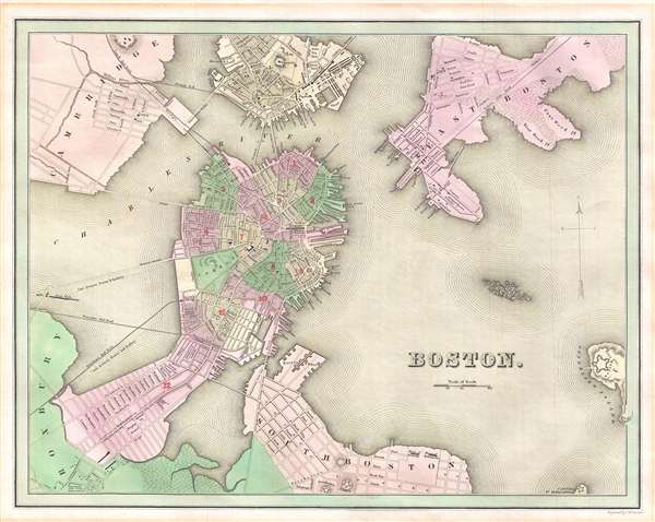
1838 Bradford Map of Boston, Massachusetts
1838 (undated) $500.00
1838 Bradford Map of Boston, Massachusetts
Boston-bradford-1838$225.00

Title
Boston.
1838 (undated) 12 x 14.75 in (30.48 x 37.465 cm) 1 : 19500
1838 (undated) 12 x 14.75 in (30.48 x 37.465 cm) 1 : 19500
Description
This is an 1838 Thomas G. Bradford map of Boston on the cusp of its transformation, via landfills and railroads, from a colonial port to a major metropolitan center. The map centers on the Shawmut Peninsula or Boston proper. It is surrounded by Cambridge, Charleston, East Boston, and South Boston, all of which follow, with some consistency, their original shorelines and are connected to Boston Proper via a network of bridges and ferries. Shading indicates areas of development and all of the 12 city wards in Boston proper are indicated. Important buildings ranging from schools to the state house are often identified, as are most piers and docks. In South Boston, the legendary poorhouses, the 'House of Industry' and the 'House of Reformation' are noted. Numerous bridges and rail lines are included, some remarkably extending straight through open water, particularly in the Back Bay area. Likewise, the boundary between Boston and Roxbury literally extends into open water, giving a clear message of the plans already in place by the city governance.
This map was engraved by G. W. Boynton and published in the 1838 edition of Bradford's An Illustrated Atlas, Geographical, Statistical, and Historical of the United States.
This map was engraved by G. W. Boynton and published in the 1838 edition of Bradford's An Illustrated Atlas, Geographical, Statistical, and Historical of the United States.
CartographerS
Thomas Gamaliel Bradford (1802 - 1887) was born in Boston, Massachusetts, where he worked as an assistant editor for the Encyclopedia Americana. Bradford's first major cartographic work was his revision and subsequent republishing of an important French geography by Adrian Balbi, Abrege de Geographie published in America as Atlas Designed to Illustrate the Abridgment of Universal Geography, Modern and Ancient. Afterwards Bradford revised and expanded this work into his own important contributions to American cartography, the 1838 An Illustrated Atlas Geographical, Statistical and Historical of the United States and Adjacent Countries. Bradford's cartographic work is significant as among the first to record Texas as an independent nation. In his long career as a map publisher Bradford worked with William Davis Ticknor of Boston, Freeman Hunt of New York, Charles De Silver of Philadelphia, John Hinton, George Washington Boynton, and others. We have been able to discover little of Bradford's personal life. More by this mapmaker...
George Washington Boynton (fl. c. 1830 - 1850) was a Boston based cartographer and map engraver active in the first half of the 19th century. Boynton engraved and compiled maps for numerous publishers including Thomas Bradford, Nathaniel Dearborn, Daniel Adams, and S. G. Goodrich. His most significant work is most likely his engraving of various maps for Bradford's Illustrated Atlas, Geographical, Statistical, and Historical, of the United States and the Adjacent Countries and Universal Illustrated Atlas. He also engraved for the Boston Almanac. In 1835, Boynton is listed as an employee of the Boston Bewick Company, an engraving, stereotype, and printing concern based at no. 47 Court Street, Boston. Little else is known of his life. Learn More...
Source
Bradford, T. G., An Illustrated Atlas, Geographical, Statistical, and Historical of the United States and the Adjacent Countries, (Boston and New York) 1838.
Condition
Very good. Some mat burn around outer margin. Blank on verso.
References
Rumsey 0089.011.