1838 Bradford Map of Boston, Massachusetts
Boston-bradford-1838-2$500.00

Title
Boston.
1838 (undated) 12 x 15 in (30.48 x 38.1 cm) 1 : 19500
1838 (undated) 12 x 15 in (30.48 x 38.1 cm) 1 : 19500
Description
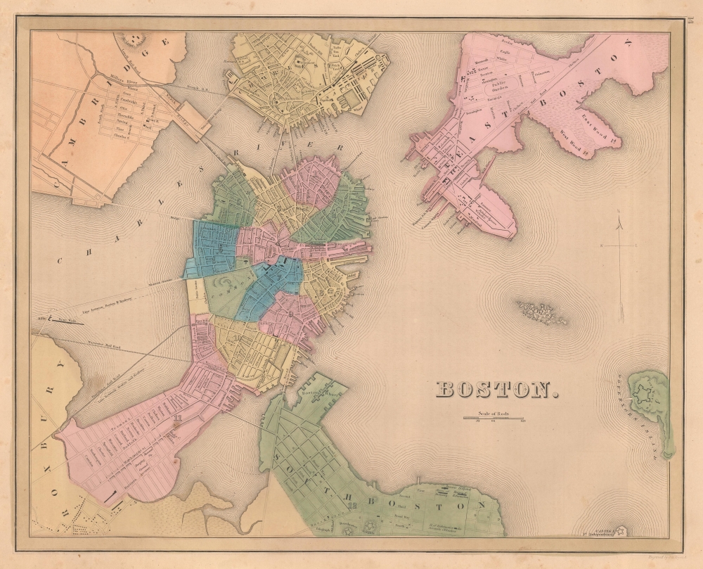
This is an 1838 Thomas G. Bradford map of Boston on the cusp of its transformation, via landfills and railroads, from a colonial port to a major metropolitan center.
A Closer Look
The map centers on the Shawmut Peninsula or Boston proper. It is surrounded by Cambridge, Charleston, East Boston, and South Boston, all of which follow, with some consistency, their original shorelines and are connected to Boston proper via a network of bridges and ferries. Shading indicates areas of development and with 12 city wards indicated. Important buildings ranging from schools to the state house are identified, as are most piers and docks. In South Boston, the legendary poorhouses, the 'House of Industry' and the 'House of Reformation' are noted. Numerous bridges and rail lines are included, some remarkably extending straight through apparently open water, particularly in what would become the Back Bay. Likewise, the boundary between Boston and Roxbury literally extends into open water, giving a clear message of the plans already in place by the city governance.Publication History and Census
This map was engraved by George Boynton and published in the 1841 edition of Bradford and Goodrich's A Universal Illustrated Atlas. The map received regular updates through the late 1840s.CartographerS
Thomas Gamaliel Bradford (1802 - 1887) was born in Boston, Massachusetts, where he worked as an assistant editor for the Encyclopedia Americana. Bradford's first major cartographic work was his revision and subsequent republishing of an important French geography by Adrian Balbi, Abrege de Geographie published in America as Atlas Designed to Illustrate the Abridgment of Universal Geography, Modern and Ancient. Afterwards Bradford revised and expanded this work into his own important contributions to American cartography, the 1838 An Illustrated Atlas Geographical, Statistical and Historical of the United States and Adjacent Countries. Bradford's cartographic work is significant as among the first to record Texas as an independent nation. In his long career as a map publisher Bradford worked with William Davis Ticknor of Boston, Freeman Hunt of New York, Charles De Silver of Philadelphia, John Hinton, George Washington Boynton, and others. We have been able to discover little of Bradford's personal life. More by this mapmaker...
George Washington Boynton (fl. c. 1830 - 1850) was a Boston based cartographer and map engraver active in the first half of the 19th century. Boynton engraved and compiled maps for numerous publishers including Thomas Bradford, Nathaniel Dearborn, Daniel Adams, and S. G. Goodrich. His most significant work is most likely his engraving of various maps for Bradford's Illustrated Atlas, Geographical, Statistical, and Historical, of the United States and the Adjacent Countries and Universal Illustrated Atlas. He also engraved for the Boston Almanac. In 1835, Boynton is listed as an employee of the Boston Bewick Company, an engraving, stereotype, and printing concern based at no. 47 Court Street, Boston. Little else is known of his life. Learn More...
Source
Bradford, T. G. and Goodrich, S. G., A Universal Illustrated Atlas, exhibiting a Geographical, Statistical, and Historical view of the World, (Boston: Charles D. Strong) 1841.
The Universal Illustrated Atlas is one of the great American atlases of the first half of the 19th century. The atlas was first published in 1838 under the imprint of Charles D. Strong. It replaced and superseded Bradford's earlier smaller format Illustrated Atlas, Geographical, Statistical, and Historical, of the United States and the Adjacent Countries. Numerous reissues of the Universal Illustrated Atlas followed until about 1848. Although there are minor variations between the editions, most contain about 50 maps, the majority of which focus on the United States. Bradford's atlases are significant for recording North America during the Republic of Texas Era. In later editions, particularly the 1846 edition, Bradford illustrates the boom in railroad construction, possibly with the idea that his maps would aid travelers in planning journeys by rail. It was compiled by Thomas Gamaliel Bradford and Samuel Griswold Goodrich with most of the plates engraved by George Washington Boynton (fl. c. 1830 - 1850). Other contributors include Thomas Gordon (1778 - 1848), Fielding Lucas Jr. (1781 - 1854), Samuel Edward Stiles (1844 - 1901), Sherman and Smith (fl. c. 1829 - 1855), and Horace Thayer (1811 - c. 1874).
Condition
Very good. Even overall toning. Light foxing.
References
Rumsey 0089.011.