This item has been sold, but you can get on the Waitlist to be notified if another example becomes available, or purchase a digital scan.
1856 Colton Map or Plan of Boston, Massachusetts
Boston-colton-1856$90.00

Title
Map of Boston and Adjacent Cities.
1856 (dated 1855) 17 x 14 in (43.18 x 35.56 cm)
1856 (dated 1855) 17 x 14 in (43.18 x 35.56 cm)
Description
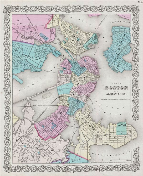
An excellent 1855 first edition example of Colton's map of Boston, Massachusetts. The map covers the entire city of Boston including the surrounding communities of Cambridge, Summerville, Charleston, east Boston, South Boston and Roxbury. Color coding identifies various city wards and districts.
This is an exceptionally interesting and important map of Boston issued just prior to the Back Bay land reclamation projection. The street and avenue grid is ghosted-in in anticipation of this enormous urban development project. Modern residents of the Back Bay may still recognize the Mill Dam (Beacon Street) and the various railroad crossings. The rest of this projection, with its large oval pond, may be more confusing. This layout is based on the real estate ambitions of David Sears, who acquired much of this property in anticipation of the impending landfill. He believed the lake, which never materialized, would make adjacent properties more desirable.
Map is hand colored in pink, green, yellow and blue pastels to define boundaries and is extremely detailed showing individual streets, buildings and parks. Surrounded by Colton's typical spiral motif border. Dated and copyrighted to J. H. Colton, 1855. Published from Colton's 172 William Street Office in New York City. Issued as page no. 13 in volume 1 of Colton's 1856 Atlas of the World.
Cartographer
Joseph Hutchins Colton (July 5, 1800 - July 29, 1893), often publishing as J. H. Colton, was an important American map and atlas publisher active from 1833 to 1897. Colton's firm arose from humble beginnings when he moved to New York in 1831 and befriended the established engraver, Samuel Stiles. He worked under Stiles as the 'Co.' in Stiles and Co. from 1833 to 1836. Colton quickly recognized an emerging market in railroad maps and immigrant guides. Not a cartographer or engraver himself, Colton's initial business practice mostly involved purchasing the copyrights of other cartographers, most notably David H. Burr, and reissuing them with updated engraving and border work. His first maps, produced in 1833, were based on earlier Burr maps and depicted New York State and New York City. Between 1833 and 1855, Colton proceeded to publish a large corpus of guidebooks and railroad maps, which proved popular. In the early 1850s, Colton brought his two sons, George Woolworth Colton (1827 - 1901) and Charles B. Colton (1832 - 1916), into the map business. G. W. Colton, trained as a cartographer and engraver, was particularly inspired by the idea of creating a large and detailed world atlas to compete with established European firms for the U.S. market. In 1855, G.W. Colton issued volume one of the impressive two-volume Colton's Atlas of the World. Volume two followed a year later. Possibly because of the expense of purchasing a two-volume atlas set, the sales of the Atlas of the World did not meet Colton's expectations, and so, in 1856, the firm also issued the atlas as a single volume. The maps contained in this superb work were all original engravings, and most bear an 1855 copyright. All of the maps were surrounded by an attractive spiral motif border that would become a hallmark of Colton's atlas maps well into the 1880s. In 1857, the slightly smaller Colton's General Atlas replaced the Atlas of the World. Most early editions of the General Atlas published from 1857 to 1859 do not have the trademark Colton spiral border, which was removed to allow the maps to fit into a smaller format volume. Their customers must have missed the border because it was reinstated in 1860 and remained in all subsequent publications of the atlas. There were also darker times ahead; in 1858, Colton was commissioned at a sum of 25,000 USD by the government of Bolivia to produce and deliver 10,000 copies of a large format map of that country. Although Colton completed the contract in good faith, delivering the maps at his own expense, he was never paid by Bolivia, which was at the time in the midst of a series of national revolutions. Colton would spend the remainder of his days fighting with the Bolivian and Peruvian governments over this payment, and in the end, after a congressional intervention, he received as much as 100,000 USD in compensation. Nonetheless, at the time, it was a disastrous blow. J. H. Colton and Company is listed as one of New York's failed companies in the postal record of 1859. This led Colton into the arms of Alvin Jewett Johnson and Ross C. Browning. The 1859 edition of Colton's General Atlas lists Johnson and Browning as the 'Successor's to J. H. Colton' suggesting an outright buyout, but given that both companies continued to publish separately, the reality is likely more complex. Whatever the case may have been, this arrangement gave Johnson and Browning access to many of Colton's map plates and gave birth to Johnson's New Illustrated (Steel Plate) Family Atlas. The Johnson's Atlas was published parallel to Colton's atlases well into the 1880s. The Colton firm itself subsequently published several other atlases including an Atlas of America, the Illustrated Cabinet Atlas, the Octavo Atlas of the Union, and Colton's Quarto Atlas of the World. They also published a large corpus of wall maps, pocket maps, and guides. The last known publications of the Colton firm date to 1897 and include a map and a view, both issued in association with the Merchant's Association of New York. Alice M. Colton married August R. Ohman (May 3, 1859 - April 22, 1934) on January 5, 1897. In 1898, Ohman joined the Colton firm, which continued to publish as Colton, Ohman & Co. until 1901. More by this mapmaker...
Source
Colton, G. W., Colton's Atlas of the World Illustrating Physical and Political Geography, (New York: J. H. Colton) 1855-56.
Colton's Atlas of the World was the brainchild of J. H. Colton's elder son George Woolworth Colton (1827 - 1901), who introduced it in 1855. The first volume, covering the United States, appeared in 1855, followed in 1856 by volume 2, which extended coverage globally. Most individual maps were extracted from Colton's earlier pocket and wall maps, reformatted, and sized to conform to the atlas standard. Disappointed by slow sales, the firm also introduced, in 1856, a consolidated one-volume version, Colton's General Atlas - although the maps are the same in both 2- and 1-volume editions. Cutting costs further, from 1857 - 1859 the General Atlas was issued without decorative map borders - these were promptly reintroduced in subsequent editions. After a disastrous map publishing arrangement with the government of Bolivia, J. H. Colton filed for bankruptcy in 1859. In this year, A. J. Johnson (1827 - 1884) and Ross C. Browning (1822 - 1899) acquired a stake in the Colton Atlas. The 1859 edition of Colton's General Atlas lists Johnson and Browning as the 'Successor's to J. H. Colton'. The nature of this relationship is unclear, as both the Colton atlases and the Johnson atlas continued to be published simultaneously for decades more, often with very similar maps. The last edition of the Colton atlas was likely 1886.
Condition
Very good. Blank on verso. Even overall toning.
References
Rumsey 0149.021 (1856 edition). Phillips (Atlases) 816.