This item has been sold, but you can get on the Waitlist to be notified if another example becomes available, or purchase a digital scan.
1859 Walling Case Map of Boston, Massachusetts
Boston-walling-1859$1,500.00

Title
Map of Boston and its vicinity, from Actual Surveys
1859 (dated) 59 x 65.5 in (149.86 x 166.37 cm) 1 : 12700
1859 (dated) 59 x 65.5 in (149.86 x 166.37 cm) 1 : 12700
Description
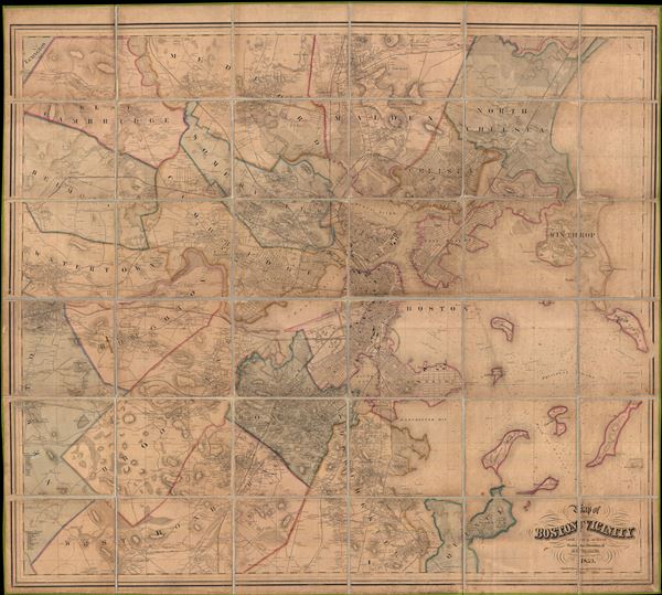
An expansive 1859 dissected case map of Boston, Massachusetts and its immediate vicinity compiled by Henry F. Walling. This enormous production is one of the large and most detailed maps of Boston to appear in the 19th century. Centered on Boston proper, Walling's map covers from Lexington to Quincy and from Newton to North Chelsea. The map identifies streets, offers footprints of important buildings, the names of significant householders, and notes public buildings, rail lines, various businesses and utilities, shipping routes, parks, and topography, as well as nautical details in Boston Harbor. Many of the buildings of Harvard College are specifically identified. The Back Bay Reclamation project, which had been planned form about 1855 on, was still in progress when Walling issued this map. In fact, work had begun only two years earlier in 1857. The project itself was not completed until 1882, however Walling here overlays the existing marshland with ghosted streets and parks.
Acting in his official capacity as Head of the State Survey, Walling's production of this map is the result, as the map itself states, of 'actual surveys' commissioned and supervised by Walling himself. Facing fierce competition from other publishers that merely copied and amended earlier maps, Walling was committed to producing a first rate modern map of both commercial and governmental viability. Walling's Boston and its Vicinity was first issued in 1857 in a slightly smaller format, with a subsequent minimally updated in a more common edition in appearing 1858. The present edition, 1859, is the third state, a physically larger map, and the only to include significant updates, among them greater westward coverage to account for urban expansion into the suburbs. There are only three known editions, this thus being the third. All examples are extremely scarce and rarely seen on the market.
Acting in his official capacity as Head of the State Survey, Walling's production of this map is the result, as the map itself states, of 'actual surveys' commissioned and supervised by Walling himself. Facing fierce competition from other publishers that merely copied and amended earlier maps, Walling was committed to producing a first rate modern map of both commercial and governmental viability. Walling's Boston and its Vicinity was first issued in 1857 in a slightly smaller format, with a subsequent minimally updated in a more common edition in appearing 1858. The present edition, 1859, is the third state, a physically larger map, and the only to include significant updates, among them greater westward coverage to account for urban expansion into the suburbs. There are only three known editions, this thus being the third. All examples are extremely scarce and rarely seen on the market.
Cartographer
Henry Francis Walling (June 11, 1825 - April 8, 1889) was an American civil engineer, cartographer, surveyor, and map publisher active from the middle to late 19th century. Walling was born in Providence, Rhode Island. He studied/worked at the Providence Athenaeum before discovering a talent for mathematics and surveying. Walling took a position with Samuel Barrett Cushing (1846 - 1888), a Providence-based civil engineer with whom he issued in 1846 a revision of James Steven's Topographical Map of the State of Rhode-Island. Walling established himself independently around 1850 and immediately began preparing a series of town plans focusing on Bristol County, near Providence. Buoyed by widespread interest in his plans, Walling expanded his operations to Massachusetts, where, by 1857, he had produced no less than 50 town plans. Apparently, Walling's business model involved a contract with town officials to produce a certain number of maps, after which he acquired the right to print and sell additional copies on his own account. This work eventually led to Walling's appointment as Massachusetts "Superintendent of the State Map", a designation that began appearing on his maps around 1855. While Walling's work focused heavily on city and county maps, he successfully published three scarce state maps: Maine, Vermont, and Rhode Island. In 1856, Walling relocated his headquarters to New York City, where he had better access to quality lithographers. The Civil War (1861 - 1865) proved difficult for Walling, and diminished sales may have forced him into a partnership with Ormando W. Gray, with whom he published numerous state, county, and national atlases in the 1860s and 1870s. Around 1880, Walling took a post with the U.S. Coast Survey, with whom he worked on various charts until requesting a transfer in 1883 to the newly formed U.S. Geological Survey. Walling remained with the Geological Survey until his untimely death of a heart attack in April 1889. More by this mapmaker...
Condition
Good. Some toning and restoration. Folds into custom made binder.
References
Boston Public Library, Leventhal Collection, G3764.B6 1858 .W35, G3764.B6 1859 .W3. List of Maps of Boston Published between 1600 and 1903, (Boston Engineering Department), no. 35-2.