This item has been sold, but you can get on the Waitlist to be notified if another example becomes available, or purchase a digital scan.
1867 Walling and Gray Wall Map of Boston, Massachusetts, and Environs
Boston-wallinggray-1867$1,250.00


Title
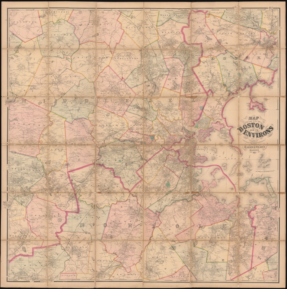
Map of the City of Boston and its Environs.
1867 (dated) 64.5 x 64.25 in (163.83 x 163.195 cm)
1867 (dated) 64.5 x 64.25 in (163.83 x 163.195 cm)
Description
This is an 1867 Henry Francis Walling and Ormando W. Gray map of Boston, Massachusetts, and environs. Boston appears to the right of center, with East Boston and South Boston both labeled. Boston Common and the Public Garden are labeled in Boston, along with streets, wharves, railroad lines, and a handful of buildings. Outside Boston, the map depicts from Wilmington, Danvers, and North Beverly south to West Medway and Walpole Centre and from Ashland Center east to Marblehead, Salem, and Beverly. Hundreds (if not thousands) of private residences are identified by the owner's name throughout, along with banks, schools, railroad stations, churches, and cemeteries. Roads, railroads, hills, lakes, rivers, and other physical features are noted.
Publication History and Census
This map was drawn and surveyed by Dunning Jackson Lake, manufactured by Henry Francis Walling and Ormando W. Gray, engraved by George Worley and William Bracher, and published by Baker and Tilden in Boston in 1867. We note eight examples cataloged in OCLC: New York Public Library, Boston College, Harvard University, the Boston Athenaeum, the State Library of Massachusetts, Salem State University, the Peabody Essex Museum, and the Wisconsin Historical Society. We also have located an additional cataloged example at the Leventhal Map Center at the Boston Public Library. Scarce on the private market.CartographerS
Henry Francis Walling (June 11, 1825 - April 8, 1889) was an American civil engineer, cartographer, surveyor, and map publisher active from the middle to late 19th century. Walling was born in Providence, Rhode Island. He studied/worked at the Providence Athenaeum before discovering a talent for mathematics and surveying. Walling took a position with Samuel Barrett Cushing (1846 - 1888), a Providence-based civil engineer with whom he issued in 1846 a revision of James Steven's Topographical Map of the State of Rhode-Island. Walling established himself independently around 1850 and immediately began preparing a series of town plans focusing on Bristol County, near Providence. Buoyed by widespread interest in his plans, Walling expanded his operations to Massachusetts, where, by 1857, he had produced no less than 50 town plans. Apparently, Walling's business model involved a contract with town officials to produce a certain number of maps, after which he acquired the right to print and sell additional copies on his own account. This work eventually led to Walling's appointment as Massachusetts "Superintendent of the State Map", a designation that began appearing on his maps around 1855. While Walling's work focused heavily on city and county maps, he successfully published three scarce state maps: Maine, Vermont, and Rhode Island. In 1856, Walling relocated his headquarters to New York City, where he had better access to quality lithographers. The Civil War (1861 - 1865) proved difficult for Walling, and diminished sales may have forced him into a partnership with Ormando W. Gray, with whom he published numerous state, county, and national atlases in the 1860s and 1870s. Around 1880, Walling took a post with the U.S. Coast Survey, with whom he worked on various charts until requesting a transfer in 1883 to the newly formed U.S. Geological Survey. Walling remained with the Geological Survey until his untimely death of a heart attack in April 1889. More by this mapmaker...
Ormando Wyllis Gray (March 3, 1829 – July 6, 1912) was a mid to late 19th century map publisher with offices in New York City, Philadelphia, PA, and Danielsonville, Connecticut. Born in Townshend, Vermont, he attended Norwich College where he studied civil engineering and became a civil engineer and surveyor. Gray's first commercial atlas was an 1869 survey of Windhamd and Toland counties, Connecticut. His most important work seems to have been done in conjunction with other, more prominent map publishers, including Henry Walling and G.W. and C.B. Colton. Gray is best known for his state and county atlases, though did, with his sons, also independently issue at least two national atlases in the late 1870s. He retired from the map publishing business in 1890. He died at home in Bernardston, Massachusetts. He married Roxcena L. Arnold in 1851, with whom he had three daughters and one son. Learn More...
George Worley (c. 1819 - November 21, 1879) was an English lithographer active in Philadelphia. Born in England, Worley lived in Philadelphia by 1843 where he worked as an artist. He worked as a lithographer for Robert Pearsall Smith in his map publishing establishment from c. 1856 - 1859. In 1858 or 1859, Worley became a partner in the firm Worley, Bracher, and Matthias with William Bracher (1827 - 1912) and Benjamin Matthias. Worley, Bratcher, and Matthias lasted until 1860 when Matthais left. After Matthias's departure, Worley and Bracher renamed the firm Worley and Bracher and remained in operation until 1879, during which time they produced over 200 maps and atlases. Worley married Ann Thakeray on March 14, 1841 and died of liver disease. Learn More...
William Bracher (June 29, 1829 - May 14, 1912) was a Philadelphia based engraver and lithographer active in the late 19th century. Bracher was born in Göppingen, Badan-Württemberg, Germany. He was a 48er, who emigrated to the United States in 1848 with his wife Amelia A. M. Bracher (born Naigele), fleeing the failed Springtime of the Peoples Revolutions (1848 - 1849). He settled in Philadelphia, where he established himself as line and stipple engraver as early as 1861. He was naturalized as a U.S. citizen on March 27, 1854. Around 1858, Bracher partnered with George Worley and Benjamin Matthais to from the printing firm of 'Worley, Bracher and Matthias'. They were active at 600-602 Chestnut Street, Philadelphia, until 1860, when Matthias left the firm. At this time, the firm was renamed 'Worley and Bracher'. In 1866, they relocated to 104 Hudson Street (rear 320 Chestnut Street) and remained until 1873. From 1873 to 1875, the firm rented at 31 South Sixth Street and then at 27 South Sixth Street until 1891. The firm appears to have shared space and often worked with a variety of private Philadelphia engravers, including Frederick Bourquin (1808 - 1897), William Hart, James McGuigan, F. C. Paxson, Henry J. Toudy (fl. c. 1857 - c. 1877), and Thomas S. Wagner. Learn More...
Dunning Jackson Lake (1836 - December 27, 1915) was a prominent civil engineer and map publisher based in Philadelphia in the second half of the 19th century. He was most born in Fairfield County, Connecticut, where he would have been a close associate of the prominent Beers mapmaking family - with whom he would later collaborate extensively. He began his mapmaking career by publishing special issue maps of Pennsylvania, Ohio, and Indiana between 1860 and 1870. In 1873 he turned his attention to atlas publishing, issuing more than 40 county atlases covering parts of Michigan, Indiana, Pennsylvania, Maryland (10 atlases), and Ohio. In 1875 he partnered with Bruce N. Griffing and 'Stevenson' to form the firm of 'Lake, Griffing, and Stevenson'. This firm published extensively until 1879, when it was dissolved. From 1879 Lake published as D. J. Lake and Co., issuing works on Kentucky, Indiana, and Illinois. He later relocated to California where he died in 1915. Learn More...
Condition
Average to Good. Dissected and mounted on linen in thirty-six (36) panels. Wear and soiling along linen fold lines. Linen reinforcements to fold separations and to linen loss at some fold intersections and along fold lines.
References
Boston Public Library, Leventhal Map Center G3764.B6 1867 .L3. OCLC 56517306.