This item has been sold, but you can get on the Waitlist to be notified if another example becomes available, or purchase a digital scan.
1861 Dutton Map of Boston Harbor and Vicinity, Early Appearance of Back Bay
BostonHarbor-dutton-1861$500.00

Title
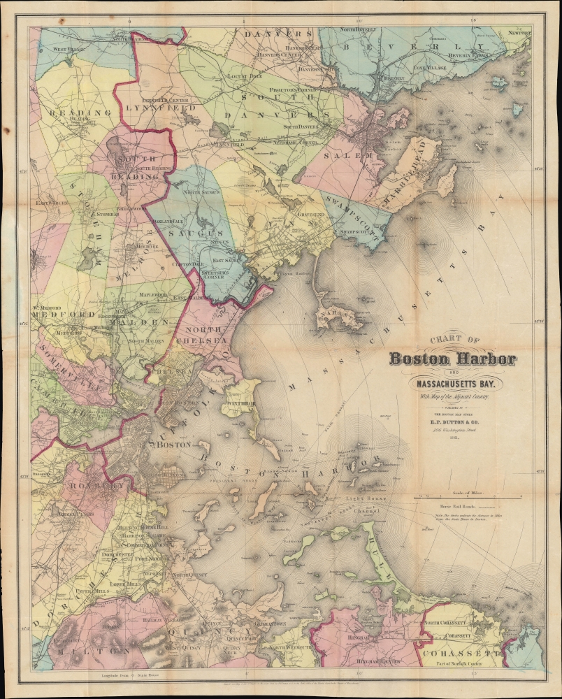
Chart of Boston Harbor and of Massachusetts Bay with Map of the Adjacent Country.
1861 (dated) 24.5 x 19.5 in (62.23 x 49.53 cm) 1 : 25000
1861 (dated) 24.5 x 19.5 in (62.23 x 49.53 cm) 1 : 25000
Description
A scarce, separately-issued 1861 pocket map of Boston and surrounding communities along the central coast of Massachusetts, published by E. P. Dutton. It is notable for demonstrating the development of Boston, in particular the initial filling in of the Back Bay.
A Closer Look
Coverage ranges from Danvers and Beverly in the north to Quincy, Milton, Hingham, and Cohasset in the south, focusing on Boston, nearby communities, and Massachusetts Bay. Important buildings, rail lines, churches, cemeteries, ferry and shipping routes, lighthouses, and topography are indicated. Boston-area landmarks such as Massachusetts General Hospital (here simply as 'hospital'), 'Tufts College' (just established), and Harvard College are readily identifiable. Outside of the most densely developed areas, individual buildings are illustrated. Towns are color-shaded for easy distinction, while thick red lines denote the divisions between counties.The Beginnings of Back Bay
This map is perhaps most significant for displaying a key stage in the development of modern-day Boston. By this time, although the South Bay between the South End, South Boston, and Dorchester remains, South Boston is almost fully elaborated, and the Back Bay makes an early appearance. Reclamation work on the Back Bay had begun only in 1857, with the first significant building in the neighborhood, the Arlington Street Church, adjacent to the Public Garden, only completed the same year that this map was published. The entire project was not completed until 1882, but here Dutton overlays the existing marshland with ghosted streets. Similarly, land reclamation in East Boston is indicated with ghosted in future development. Future land reclamation would be undertaken in Cambridge and Charlestown, and the continued growth of Boston led to its annexation of Roxbury, Jamaica, Dorchester, and Charlestown in the 1870s.The Cambridge Horse Railroad
Another interesting feature of this map is the Horse Railroad, which connected downtown Boston with Cambridge, Old Cambridge (now Allston), and extended westwards to Watertown. Service had only recently begun in 1856 and remained popular throughout the rest of the century. The portion between Harvard Square and downtown Boston was electrified in 1889, with other portions following suit soon afterwards. The opening of a subway line mostly along the same route in 1912 doomed the slower streetcars, but they remained in service until 1949.Publication History and Census
This map was published and sold by E. P. Dutton in 1861. It may be based on, and was at least likely influenced by, Henry Walling's very large 1859 case map of Boston and vicinity (previously sold by us). The only known examples of this map in institutional collections are held by Harvard University and the New York Public Library, while a second edition published in 1865 is held by seven institutions. In 1867, the map was republished in the short booklet Plan and Suggestions for improving Boston Harbor and, incidentally, the vicinity, published by Dutton, which is also quite scarce.Cartographer
Edward Payson 'E.P.' Dutton (January 4, 1831 - September 6, 1923) was an American book publisher. Born in Keene, New Hampshire, Dutton was the son of George Damon Dutton and Mary Dutton. In 1852, Dutton founded the E.P. Dutton bookselling company in Boston, Massachusetts. Dutton initially sold fiction and nonfiction books, but soon included children's literature in his inventory. In 1864, Dutton opened a store in New York City and permanently moved his operation there in 1869. In that same year Dutton began publishing books. In 1888, Dutton began working with Ernest Nistor, and in 1906 Dutton struck a lucrative deal with the English publishing firm J.M. Dent to be the American distributor of the Everyman's Library. Even after his death, Dutton's company continued to grow prosper and is now an imprint of the Penguin Group. Dutton married Julia Maria Sleeper. More by this mapmaker...
Condition
Good. Several rust spots outside border. Toning and wear on original folds. Small holes at juncture of folds.
References
OCLC 1323580961. Harvard Map Collection MAP-LC G3762.B65 1861 .E2.